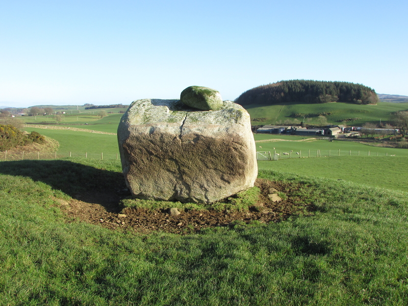
Large Field clearance stones on NW Quadrant of Ballach-a-Heathry cairn. (08.03.20)

Large Field clearance stones on NW Quadrant of Ballach-a-Heathry cairn. (08.03.20)

Visited 08.03.20
Ballach-a-Heathry cairn is a robbed out grassy cairn of uncertain age. It lies 2 miles NE of Glenluce on the Three Lochs road. It is approximately 20 yards across its N-S axis and 12 yards across the E-W axis. The cairn is grassed over with a deposit of large field clearance stones on the N of the cairn. There is no evidence of a cist.
Given its position in flat pastureland the cairn is quite prominent despite the recent addition of wind turbines. A gate provides easy access to the cairn.
Last visited in 1976, Canmore ID 62413 gives further details of the cairn (go to Links).


Visited 08.12.19
Cairn Kenny lies around 500m NE of High Murdonochee summit in extensive moorland S of Arecleoch Forest. Access is possible from the railway crossing at Miltonise Farm however I chose to approach from the Lagafater Lodge road N of Penwhirn Reservoir.
In hindsight this was a mistake since the road was private before Barnvannoch Farm requiring an extra 2km walk to reach the Lagafater Dam, before walking 4 km over rough wet moorland via High Murdonochee. I would suggest that walking from Miltonese would be shorter, around 3km each way. A GPS or good map reading is essential to find Cairn Kenny.
Cairn Kenny is a chambered cairn around 17m across by 2m high with a robbed out central chamber. Many scattered stones are left in situ on a green turfed cairn which is visible from a distance. Further details are available in Canmore ID 61771 (go to Links).


Visited 08.03.20
Miltonise North cairn lies 30m E of the Stranraer to Girvan railway line 650m NNE of Miltonise farm (as noted in Canmore ID 61803 (go to Links)).
It is a robbed out cairn, approximately 10m across with an off-centre kist exposed. The kist is a 0.5m square, approximately 0.5m deep with two stone slabs remaining in situ. A third potential stone slab lies within 1m of the kist.
A small scattering of buried stones remain on the grass covered cairn, which stands out as a green spot surrounded by brown moorland.
In this rough moorland the cairn is almost invisible until one is standing over it.
Canmore ID 61803 also notes that a second cairn 5m in diameter, covered in peat lies 10m S of this cairn however I was unable to locate this feature.
Canmore ID 61853 (go to Links) describes Miltonise South cairn, which is positioned approximately 400m S. Again, it is a turfed over cairn, around 6m in diameter. I was unable to investigate this due to the proximity of beef cattle in the area.
Re-Visited 27.02.20
I summited Knockdolian many years ago but lost the photos so I had a good excuse for a second visit.
The short steep walk more than compensates the effort required with fantastic 360 degree views including Ailsa Craig to the NW.
Approaching Ballantrae from S, I crossed the Stinchar Bridge and turned right beside the old castle. After 3 miles on the B7044 there is a sign for the Knockdolian Hill path. It is possible to park beside a wood a quarter of a mile beyond this point. Retrace your steps and start the steep obvious ascent up a grass field leading onto a ridge towards the summit.
I was expecting a stonier cairn however the grass cairn at the summit looks like a natural knoll. There are no kerb stones, as noted in Canmore ID 62028 (go to Links), just a few rock outcrops.


Torhousekie Farm Cairn centre, covered in scattered stones. (30.07.11) This is from the N bank of the cairn just after a squall so the light is subdued.
Visited 23.02.20
Torhouskie Farm Cairn lies 200 yards E of the farm. It is in a ruinous state, only the outline of a 25 metre cairn and an earth bank remaining.
Canmore ID 62842 (go to Links) suggests it is a robbed out bell-cairn.
It may be accessed by parking at Torhouse Stone Circle and walking back towards the farm around a quarter of a mile. There is a gate into the adjacent field which provides closer access.
The raised earth bank and intermittent perimeter of stones give a clue as to how impressive this cairn would have been in its youth.
There is a scattering of smaller stones at the centre giving the impression of concentric circles. However, these stones may be a later addition due to field clearance.

Dry Stane Dyke and clearance stones in close proximity to lost cairns could explain their disappearance.


Visited 20.02.20
On a changeable day with sleet showers I explored the potential cairns to the N of Torhousekie Stone Circle.
There are two candidates listed on Canmore under Torhousekie:
Canmore ID 62839 (go to Links). This was a large cairn 140 yards N of the circle however no trace was found on 18th August 1970. The building of dry stane dykes was blamed for its removal.
Canmore ID 62875 (go to Links). This was a large conical cairn, 166 yards N of the circle. It was last observed on 18th August 1970 as “remains of a dilapidated cairn, 28.0m in diameter and 1.0m maximum height. It’s top is thickly covered with field clearance stones”.
Fifty years have passed since then so we should not be surprised that both cairns are now invisible.
There are many field clearance stones in the corner of the field which bounds the cairn sites and extensive dry stane dykes which would account for their eradication.
Approximately 30 yards E of Canmore ID 62839 there is a small plie of field clearance stones on a natural knoll. At the stated position of Canmore ID 62839 there is a natural knoll with some earth-set rocks but no visible scattered stones.
30 yards N there is an arable grass field next to a farm track. The ploughing of the field has removed any trace of Canmore ID 62875. I have included a picture of the site in case more experienced eyes can spot anything.
Visited 03.07.11
After a grid search of the hillside around NB 177 345 I found a viable candidate for Callanish XV at NB 17753 34588. The recumbent stone was c. 7 feet NE-SW and 4 feet SE-NW. This site is actually Callanish XV. See Canmore ID 72849 for further details (go to Links).

Beoch Hill cairn is 300 yards S of White Cairn, Beoch Hill. It’s a smaller cairn, around 10 yards across with a hollowed out centre.
See White Cairn, Beoch Hill for directions. From the White Cairn walk S towards a gate around 200 yards away. Beoch Hill cairn is a grassy bank 100 yards S from the gate in rough moorland.
It is listed as Canmore ID 60701 (go to Links).
White Cairn, Beoch Hill is a robbed cairn on rough moorland near the summit of Beoch Hill.
I parked at the Observation Post at NX 1093 6679 on the road to Penwhirn Reservoir. I headed W across rough ground over a shallow valley onto Beoch Hill. The moorland became drier at the summit of the hill. White Cairn, Beoch Hill required a GPS to find the low lying cairn, hidden in a patch of long grass. A scattering of white stones and a central clearing is all that remains.
Canmore ID 60690 (go to Links) states that it “had been almost obliterated by 1911.”
Visited 24.08.19
Thanks to persistence and drewbhoy’s pictures, I managed to find this shy and retiring recumbent stone after 15 minutes of tramping in moorland. The stone lies in a hollow guarded by reeds. As ever, I thought it should be easier than that so I have formulated an improved method to find Glac A’ Charraigh.
Park in the large passing place 150 yards before the sharp corner at NR 29643 43061. Walk 200 yards NE from the gate at the corner of the field. If the stone is not visible look for a small clump of reeds concealing it. You need to be almost standing over it. The choke stone is easier to spot than the recumbent stone.
My grid reference for this site was NR 29754 43158.
Canmore ID 37289 (go to Links) describes it as a standing stone on their last visit in 1977.

Visited 22.08.19
I parked at the Kintra campsite. I had to turn back at the ford to get my wellies and stick for the burn crossing. They came in handy later. Frachdale ruin was easily reached and a rough road ran up the hill to Frachdale Chambered Cairn and Coille A’chnoic Mhoir standing stone, easily spotted a quarter of a mile up on the right. As drewbhoy observed Frachdale Chambered Cairn was less accessible. I went through the gate at the top of the hill and followed my GPS South down a steep ferny slope crossing a boggy valley to the summit of the mound. The cairn itself is vegetation free, unlike its surroundings. I retraced my steps to return, avoiding further adventures.
Canmore ID 37607 (go to Links) give further details of Frachdale Chambered Cairn.

Following in the stumbling footsteps of drewbhoy, I spent 20 minutes searching for Princess Yula’s Stone only to bump into it as I was leaving, unsuccessful in my quest. It was at this happy point that I realised there were less than 20 yards between the two stones! To prevent future Antiquarian’s frustration I have devised a GPS free solution:
Take the A846 out of Port Ellen, reaching Ardbeg after Laphroaig and Lagavulin. The road narrows to a single track for a further 2 miles until you reach the scenic Loch a Chnuic bay. There is an uphill hairpin at the end of the bay. 20 yards before the apex of the hill there is space to park snugly beside a black wrought iron gate on the right.
Walk down the hill 10 yards, look right to the smaller stone nestled in the edge of the wood. The low fence is easily negotiated. To find the second stone stress free, stand on the left of the smaller stone facing the trees, walk 10 yards forward at which point you should notice a faint path to your left. Follow this path for 10 yards and you will find the Fairy Dell that hides Princess Yula’s final resting place.
Canmore ID 38030 (go to Links) casts doubt on the relationship between the two stones , stating that the road side stone “is a smaller, insignificant set stone of doubtful association.”


Cairn MacNeilie, Cruise lies in a field N of Cruise farm on the minor road between Glenluce and New Luce, around 1 mile from New Luce.
Canmore ID 61666 (go to Links) describes it as a circular cairn of 17 metres across which has been expanded by field clearance stones. The top of the cairn is covered in whins which discouraged my investigation of a possible cist.
Cairn Macneilie, Inchparks is 7.4 km WSW of this site.

Maryholm Stone, 50 yards NW of large tree near the river Nith


Wallace’s stone is situated at Blairston Mains, the 1st non-private left turn on the B7024 to Maybole after leaving Alloway.
The stone is surrounded by a solid stane wall in a strip of trees.
The carving is suggested as a representation of Wallace’s sword but looks more like a cross to me, however some interpretation is required.
Canmore ID 41595 (go to Links) has more information on this site, suggesting the carving is “a cross in false relief” dating from the “10th to 12th century”.
Bain’s Hill or the Stinnie Stane is located at the northern boundary of Trump Turnberry. Park in the Malin Court Hotel restaurant car park. Head up to the flagpole and you will see the stone at the top of the hill.
Bain’s Hill is listed under Canmore ID 40856 (go to Links).


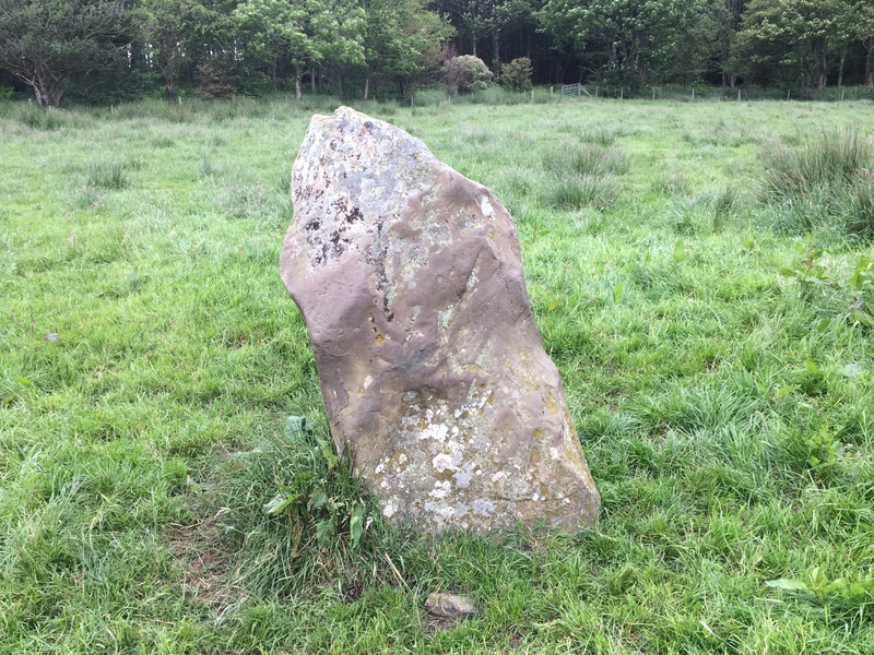
Logan House Garden is open from 1st February to 31st August. Follow the sign after going through Ardwell on the A716.
The standing stone is on the left of the one way avenue after around half a mile. The trees on the left make way for a large field in which the Logan House standing stone can be seen.
Canmore ID 61138 (go to Links) states “it is possibly a prehistoric standing stone.” The stone is c. 1.5m tall.


Kells farm is on the A710 along with its neighbour, Home Farm, which has two stones to visit. Kells Standing Stone is a 5 foot granite slab in a field SW of Kells.
It is listed as Canmore ID 65404 (go to Links).