

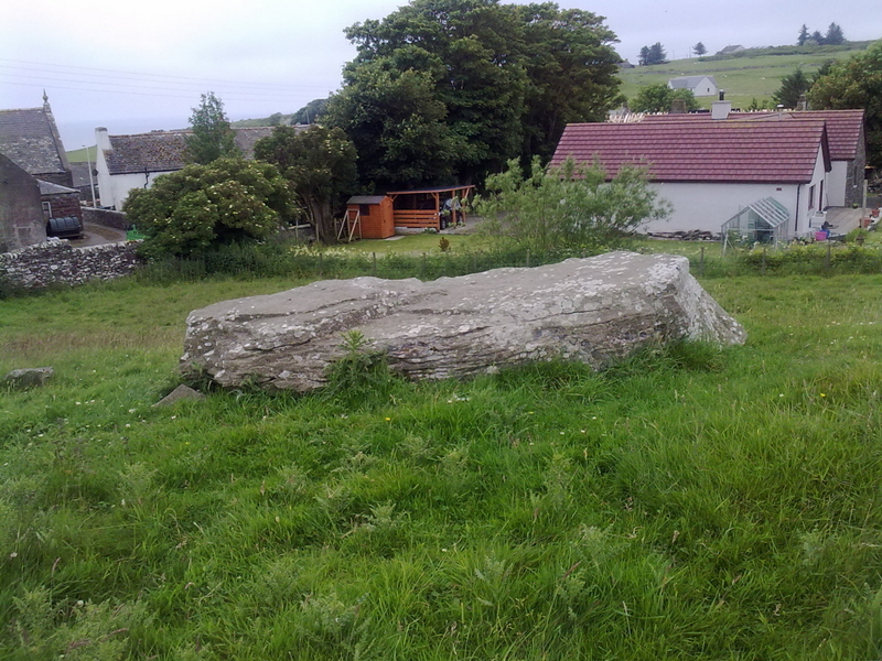
I found this stone by sight as I was travelling S out of Twynholm. On passing Ingleston farm I noticed a large stone on the right side at the top of a hill.
I couldn’t find any online references to this stone but found it marked on my OS landranger map.
The Ingle Stone is a massive erratic measuring around 10x10x8 feet. There is a small moss-covered stone resting on top of the Ingle Stone. It is no wonder that the Ingle Stone has not been moved and has given the farm it’s name due to its prominence in the landscape.


Peatshiel Sike from SE, framed by Saddle Yoke and Carrifran Gans summits. Was a lunar standstill in this groove the reason for erecting this stone?

Peatshiel Sike, looking NE towards Bodesbeck Law. Does the profile of Peatshiel Sike mimic the summit profile of Bodesbeck Law?


The Devil’s Jump is located in Cornwall, between St Breward and Camelford, c. 500 yards N of Carweather Medieval Village. There are two granite crags c. 300 yards apart on either side of a wooded valley. It is marked on OS Mapping. The N crag is located at SX 10200 80240 and the S crag at SX 10198 79977. The S crag is more prominent and easier to access via the Carweather Medieval Village public path. There is a public path on the eastern side however access to the N crag is limited.
I thought that a pillar of granite on the S crag viewed from SW bore a resemblance to a bearded devil, maybe giving the site its name.

Buldoo 1, high and handsome. The recumbent stone is visible to the left of Buldoo 1 close to the house.

Visited 06.07.11
The 12 foot tall standing stone is easy to spot but the second stone is more reclusive. Canmore ID 8132 (go to Links) gives its location as ND 1992 3374. The split stone is around 6 feet high beside whins at the edge of the field. I’m not sure of the relationship between these stones. They’re like Arnold Schwartzenegger and Danny De Devito in Twins.
There is a large recumbent stone c. 70 yards SW of the taller menhir at the edge of Latheron. It seems like a better partner for the 12 foot stone. Canmore ID 8660 makes no mention of it.

Visited 24.01.12
Dun Flodigarry broch is located within the grounds of the Flodigarry Hotel. It is in a ruinous state, being reclaimed by natural forces.
Canmore ID 11388 (go to Links) gives details of an excavation on Dun Flodigarry carried out from 1978 to 1981.
It should be easy to visit Kirroughtree House Cairns, High & Low Lessons and Creebridge Cairn in the same day if you have not already visited them.


Take the A712 turn off the A75. Take the second left for Kirroughtree /Conifers Lodges, a single track road with passing places. After 500 yards there is a passing place at NX42646579 where you can stop safely.
Kirroughtree House N lies 250 yards N in a field. It look just like a natural grass mound until you are close enough to the slight hollow in the summit. It is a naked cairn that blends into the landscape.
Canmore ID 63431 (go to Links) verifies its status as a cairn.
Take the A712 turn off the A75. Take the second left for Kirroughtree /Conifers Lodges, a single track road with passing places. After 500 yards there is a passing place at NX42646579 where you can stop safely.
Kirroughtree House W cairn is visible 200 yards SSW.
It is around 20 yards across with a large tree growing out of the mound and an outline of a circular stone enclosure. The summit is stony and grass-covered with no visible cist.
The cairn itself and its lower location make it less impressive than its neighbour, Kirroughtree House E.
See Canmore ID 63442 (go to Links) for more details.
Take the A712 turn off the A75. Take the second left for Kirroughtree /Conifers Lodges, a single track road with passing places. After 500 yards there is a passing place at NX42646579 where you can stop safely.
Kirroughtree House E Cairn is a large cairn around 20 yards across, planted with a ring of mature trees and surrounded by a tumbledown dry stane dyke. Kirroughtree House W cairn is visible 200 yards NNW. Head for this and take a gate left into an adjacent field. Kirroughtree House E is 200 yards E.
The cairn has a commanding view towards Creebridge and the A75. The trees and the wall lend the cairn a greater presence in the landscape.
There are some exposed stones on the cairn but no cist visible.
Canmore ID 63441 (go to Links) gives a fuller account of the cairn.

Ailsa Craig Castle from above. It looks like it’s perched on the sea but it is sited inland.


Visited 17.07.13
It was third time lucky on the MV Glorious out of Girvan. We were turned back by the waves on two previous trips but persistence rewarded me with around two hours on the rock.
The rock has a lighthouse, two foghorns, a ruined tower house and industrial remains on the shore. It is famous for Ailsite granite curling stones which are prized for their durability. Some unshaped stones can be found on the beach.
There is more vegetation than is apparent from a distance and the grassy summit is 338 metres above sea level.
There is a parking lay-by at NX42746533 on the B7079 just before the A712 junction. Walk towards Creebridge observing Low Lessons in the field to the right. Around 200 yards there is a gate into the field with Low Lessons lying 200 yards WNW. High Lessons lies a further 200 yards WSW beside the stone wall, partially fenced off. Only an outline remains with a stony base. There is a gate just beyond High Lessons onto the footpath.
Canmore ID 63434 (go to Links) give futher information on Low Lessons and Canmore ID 63433 (go to Links) on High Lessons.


