markj99

markj99

All posts expand_more 1,201-1,250 of 4,112 posts

Airyolland W

Visited on 29.07.23

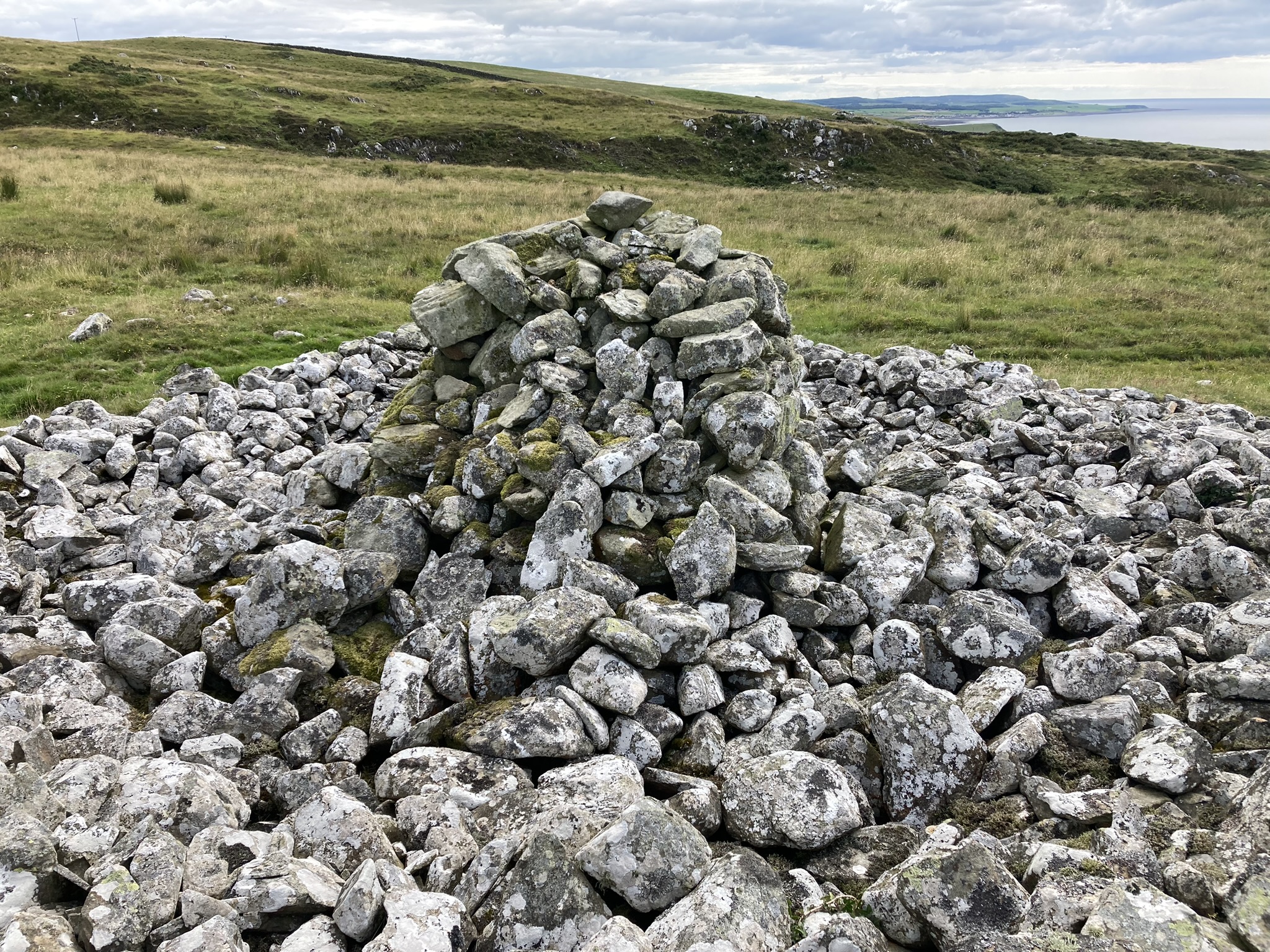
Airyolland W Cairn is located c. 0.6 miles NNW of Elrig, a small village in Dumfries and Galloway. Airyolland Farm is c. 0.6 miles SSW of the irregular stony mound constructed in pastureland. Airyolland W Cairn measures c. 80 feet in diameter and c. 8 feet high. The mound retains a covering of stones except for the W half of the cairn which has a grassy surface with scattered stones. Low traces of ruined enclosures can be seen c. 20 yards E of Airyolland W Cairn. Canmore ID 62703 has details of Airyolland W Cairn.

Airyolland E Cairn is c. 50 yards NE of Airyolland W Cairn.

Airyolland E

Visited on 29.07.23

Airyolland E Cairn is located c. 0.6 miles NNW of Elrig, a small village in Dumfries and Galloway. Airyolland Farm is c. 0.6 miles SSW of the round mound lying in pastureland. The grassy platform has been reduced to c. 3 feet high with a c. 60 feet diameter. Medium-sized field clearance stones have been scattered on the surface of the cairn, especially on the NW half. A standing stone, c. 4 feet tall, has been erected in the centre of the platform. It is probably a modern addition to the monument. Canmore ID 62703 has details of Airyolland E Cairn.

Airyolland W Cairn is c. 50 yards SW of Airyolland E Cairn.

Miscellaneous

Corwall S
Cairn(s)

Directions to Corwall S Cairn.

An old farm track winds up from the coastal road, A747 to Port William, at Chapel Finian. There is a large grassy car park at NX 2794 4876, on the right of the A747. Walk NE along the road for c. 175 yards to reach a wooden gate on your right, c. 40 yards SE of Chapel Finian, at NX 2786 4887. A vague farm track starts here. The track is overgrown at first but clears into a wide grassy track as it nears Corwall Farm. Two cairns can be accessed from this track. After c. 1 mile there is a gateway into open moor at NX 2855 4915. Corwall S Cairn is c. 270 yards ESE of this location. Retrace your steps WNW to return to the track. Continue N through semi-derelict Corwall Farm to reach a gateway at NX 2897 4946, just before a ruined cottage on your right. Corwall E Cairn is c. 275 yards ENE from here in a grassy field. There is a marker cairn on the cairn to guide you to it. My route can be viewed on Corwall Cairns.

Miscellaneous

Corwall E
Cairn(s)

Directions to Corwall S Cairn.

An old farm track winds up from the coastal road, A747 to Port William, at Chapel Finian. There is a large grassy car park at NX 2794 4876, on the right of the A747. Walk NE along the road for c. 175 yards to reach a wooden gate on your right, c. 40 yards SE of Chapel Finian, at NX 2786 4887. A vague farm track starts here. The track is overgrown at first but clears into a wide grassy track as it nears Corwall Farm. Two cairns can be accessed from this track. After c. 1 mile there is a gateway into open moor at NX 2855 4915. Corwall S Cairn is c. 270 yards ESE of this location. Retrace your steps WNW to return to the track. Continue N through semi-derelict Corwall Farm to reach a gateway at NX 2897 4946, just before a ruined cottage on your right. Corwall E Cairn is c. 275 yards ENE from here in a grassy field. There is a marker cairn on the cairn to guide you to it. My route can be viewed on Corwall Cairns.

Corwall E

Visited 24.07.23

Corwall E Cairn is a grassy round cairn located c. 0.9 miles from the coast, c. 5 miles NW of Port William in Dumfries and Galloway. The low platform is situated in pasture c. 450 yards ENE of Corwall Farm. Corwall E Cairn, which measures c. 40 feet in diameter and 1.5 feet high, has an irregular perimeter with a line of kerb stones on the N Arc. A modern marker cairn, 3 feet high, has been erected on the N Arc. The cairn has been extensively stone-robbed, leaving a grassy surface with scattered stones. Canmore ID 62127 has further details of Corwall E Cairn.

Corwall S Cairn is c. 700 yards SW of Corwall E Cairn.

Corwall S

Visited 24.07.23

Corwall S Cairn is a stony round cairn located c. 0.5 miles from the coast, c. 5 miles NW of Port William in Dumfries and Galloway. It is constructed in rough pasture c. 450 yards south of Corwall Farm. The stony central hollow of the mound is surrounded by a grassy perimeter. Corwall S Cairn measures c. 50 feet in diameter and 3 feet high except for the central modern marker cairn which reaches up to 6 feet high. Canmore ID 62125 has further details of Corwall S Cairn.

Corwall E Cairn is c. 700 yards NE of Corwall S Cairn.

The May

Visited 16.07.23

The May Cairn is a low mound located c. 100 yards SSW of The May Farm, c. 5 miles NNW of Port William in Dumfries and Galloway. The circular platform has a flat grassy surface. The perimeter of the cairn is studded with small exposed stones. It measures c. 54 feet in diameter and 2 feet high. Canmore ID 62915 has further details of The May Cairn

The May Cairn is one of a small cluster of cairns at The May consisting of Court Cairn, The May and Lang Rigs.

Lang Riggs (The May)

Visited 16.07.23

Lang Riggs (The May) Cairn is located c. 400 yards SSW of The May Farm in Dumfries and Galloway. The round cairn, situated in the centre of a field, was reduced to c. 60 feet in diameter and 4 feet high according to a 1911 account in Canmore ID 62205. The grassy platform has been used as a dumping ground for medium to large field clearance stones, mostly round the perimeter, increasing its height to c. 6 feet. Canmore ID 62205 speculated that the cairn was excavated by the Marquis of Bute in 1942. A stony trench in the eastern half may be the result of this excavation.

Court Cairn is one of a small cluster of cairns at The May consisting of Court Cairn, The May and Lang Rigs.

White Loch of Myrton

Visited 16.07.23

White Loch of Myrton Crannog is located in the SE corner of the loch c. 1.5 miles N of Monreith, a coastal village in Dumfries and Galloway. According to Canmore ID 62814 the crannog was constructed as a stone mound bounded by c. 100 vertical piles driven into the loch bed. The surface of the crannog is densely tree-covered obscuring any signs of occupation. There is no visible evidence of a causeway from the east bank due to a high water level.
White Loch of Myrton Crannog is accessible from a public path round the loch in Monreith House Estate. Parking is possible at the estate entrance. The best views of the crannog are from the west bank. It is possible to approach the crannog from the east via a woodland path veering off the loch circuit. The views of the crannog from the east bank are restricted by trees bordering the loch. My route is viewable on White Loch of Myrton.