
The disc barrow adjacent to the enclosure looking West
Image credit: A R Cane
The disc barrow adjacent to the enclosure looking West

Inner banks of the enclosure looking West along the South Downs

Possibly the only sarsen in the village.... I meant West Sussex.


Eyes shut and in a deep, deep sleep, lulled by the passing traffic on the Shoreham Road. At least from this angle anyway.

Looking South towards DFS and Burger King!!

Sited conveniently next to the carpark for picnics. What foresight!
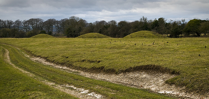
The 3 linear barrows flanking the carpark.

360’ panorama from the middle rampart at the main entrance.


Looking back up to the Rings from the carpark. The 4th and smallest barrow in the cemetery group is just visible on the right hand side.

The faint trace of the Ackling Dyke, Roman Road running NE/SW to the north of the Rings.


Panorama from the top bank looking south towards Worthing and the sea.

The stones in all their cold, sombre, wintery glory. My first visit although I must have passed it dozens of times without noticing it’s secluded delights!

The ring looking from the entrance.

Looking back towards the road and the back of the mighty truncated tree.

Panorama of Ranscombe camp and the South Downs from Mount Caburn.


Another of the many barrows around the top of Firle Beacon, this one slightly truncated by a farm track.

If the large barrow at the top of Firle Beacon is a long barrow, what is this? Conjoined round barrows? This is the view looking South West.


The lower and reasonably well defined disc barrow next to the South Downs Way footpath.

The higher, and much less distinct, disc barrow adjacent to the South Downs Way footpath.

Panorama from the top of the bowl barrow looking west over the South Downs. The long barrow, barely visible, lays at the edge of the hill and to the right.

Panorama of Windover Hill and the long barrow viewed from the ascending SouthDowns Way path from the west.


Interior of the camp at the furthest point from the track.

Panorama of the camp from the track running alongside looking North West.

One of the 2(?) disc barrows near the car parking area.

Facing more or less due South.

Two days later during the day, though a little overcast and gloomy, but still mightily impressive.

Facing North East in the gathering gloom. It’s quite an eerie place at night even though there’s an isolated house just 100m from the stones.

Facing North West. Can’t help thinking it looks just a little bit phallic from this angle?

Panorama looking back East across the island from the ‘Harboro’.

Facing West with the Tennyson Down cliffs just visible.

A small ring of stones set into the top of one of the largest barrows, the ‘Harboro’. Nice touch, but not ancient! These were placed here in WW2, I believe, when this spot was an Observation Post. There’s also a lump of concrete sticking out of the south eastern edge which may have been part of a larger structure.

Looking back towards Five Barrows on the left and behind that the Solent and the mainland.


Facing West with Compton Bay, The Needles and the Solent in the background.

Panorama facing South East with the best defined barrow in the foreground.

Panorama from the top of a barrow in the South West corner.

A cross dyke on the Tennyson Trail above Freshwater Bay.

Another view of the ‘Neolithic Mortuary Enclosure looking North East.

According to the notice board at The Needles this is a neolithic mortuary enclosure (simply an ‘earthwork’ on the OS Explorer map for the I of W). It’s situated right next to the Tennyson Trail on Tennyson Down just up from Freshwater Bay.

A pair of rather lowly barrows near the Tennyson Monument and the footpath leading to The Needles behind.

One of the Bronze age barrows on West High Down with the valley that leads down to the rather tacky Alum Bay in the background.