
Painting by Francis Nicholson (1753-1854) hanging in the house at Stourhead, Wiltshire – once the home of Richard Colt Hoare.
Image credit: tjj
Painting by Francis Nicholson (1753-1854) hanging in the house at Stourhead, Wiltshire – once the home of Richard Colt Hoare.
wiltshiremuseum.org.uk/news/index.php?Action=8&id=174&page=0
I visited this exhibition in Devizes Museum yesterday – it wasn’t an exhibition in the regular sense as, although the items were numbered, they were interspersed among the museum’s excellent permanent collection. There were some surprises – a bowl from West Kennet Long Barrow, the Roundway Down Archer (neither of which I had seen before).
It seems to be a county wide project so worth checking the other museums too.
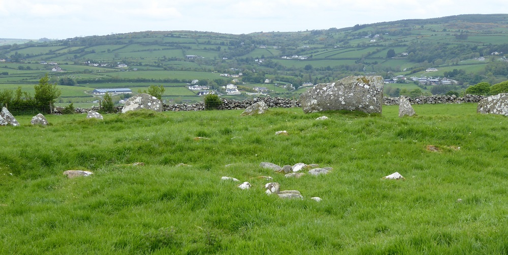
My final stony entry from my memorable holiday in Donegal. This is thanks to my map reading, tomb hunting companion for the week. After visiting the Muckros peninsula, we found a rather breath taking megalithic tomb at Kilbeg on top of hill overlooking Teelin Bay and the Slieve League mountains. We had to climb over a fence and up a hill to see it – I must admit to being a little reticent but friend went up the hill first before urging me to follow. I did and it was so worth the climb to the top of the hill – siting a tomb in such a place of wild beauty makes so much sense when you are actually there. The tomb is basically what we would describe as ruined but still very recognisable as a court tomb.
Nearest town Kilcar, Map ref: OSI (Ireland) Discovery Series, No. 10, grid ref: 598755. This series of maps has all the megalithic tombs and other ancient monuments shown on it so an ‘essential’.


Visit to what we thought Shalwy Court Tomb 23rd May 2016. Having read Gladman’s field notes and studied the existing photos I think we may have found Croaghbeg so am transferring my original field notes from Shalwy to Croaghbeg. Both close to each other and both very difficult to access.
Tuesday dawned warm and sunny and in the morning we set off to find Shalwy /Croaghbeg Court Tomb (east of Kilcar: our ref – OSI 648753).
Using OSI map (my friend is pretty good at this) we parked car in layby on the main road out of Kilcar and walked down a steep single track road, turning right at the bottom. We then walked about a mile along a straight(ish) narrow road to the next right turn back uphill – the walk overlooked the sea which was sparkling that morning, early foxgloves had started to appear, a peat stream fell down the hillside and appeared from under the road on the other side to tumble down the rocks to the sea. Quite a few houses along this road, all well spaced out and beautifully maintained, some unoccupied, probably holiday homes. In fact we asked a woman who was painting her garden bench for directions and it was she who directed us back uphill to the spot where we could a large, newly built grey house on the side of the hill.
Walking back uphill again, we passed a well at the side of the overgrown track – this beautiful wild hillside now has individual houses appearing (something we noticed around Kilcar too) and we finally spotted the rather splendid court tomb – with a four stone chamber standing separately in the court area – at the bottom of the hill behind the houses we had walked past earlier and immediately below the new grey house, which didn’t appear to have anyone living in it (another holiday home perhaps). The court tomb was surrounded by nettles and brambles, the climb down very steep. My intrepid friend was up for it but I wasn’t – mindful of the fact there is often no mobile phone signal in Donegal (and there wasn’t here) I felt it wasn’t worth the risk of turning an ankle or otherwise injuring self so settled for taking a photo with my zoom. Yes, I admit to being a wimp but this wimp went on to have lunch in Killybegs before spending the afternoon exploring a narrow unspoilt peninsular known as St. John’s Head – which has a lighthouse at the end and a coral beach.


The only partially supported tomb of the six – probably because bordering someone’s garden.


We visited these on our second visit to Glencolmcille, after going back to Cloghanmore (and last full day of the wonderful week in Donegal) . Our first attempt had been unsuccessful as we weren’t able to find them. This time we asked in the visitors centre/gift shop and were given a little hand drawn map. Leaving Glencolmcille on the road to Malinbeg just over a bridge we turned right up a narrow road to some farms (a house on this turning had a rather impressive garden ornament in the shape of a small portal tomb). The six great portal tombs were not in such good condition – they span two narrow fields both of which had farm animals in them. The three in the first field had three nursing cows with their off-spring standing close by. The cows became agitated by our presence at the gate so we decided to not go in the field. All three of these enormous tombs were unrestored and partially fallen. The other three tombs were in a similar state although the largest one was partially restored with some supporting stonework – also partly in the garden of a nearby house. The second field had a ram and ewe standing guard – again we erred on the side of caution and didn’t enter the field.
This short passage is taken from “Gleancholmcille – A guide to 5000 years of history in stone” by Michael Herity:
“ … towards 2000BC, Gleancholmcille was lived in by a later group of stone age farms with a rather different style of tomb building. Their monuments are portal tombs. This type is well represented near Gleancholmcille – on the north side of the valley behind the school and again across the valley to the of Cloghanmore. At the west end of Malin More valley, six portal tombs arranged in a line are part of one huge, unusual monument, probably 90m long originally”
Edit: Have belatedly posted a photo of a beautiful white quartz stone which incorporated into the field wall by the Malin More tombs. Given the tombs are in a ruinous state I do wonder if this stone was taken from one of them?
I had seen the sign for Drumskinny Stone Circle on the journey towards Donegal and made a mental note to try and visit on the way back as just over the border with Northern Ireland in County Fermanagh off the main road between Donegal Town and the village of Kesh. The monument consists of a stone circle, cairn and stone alignment and comes as something as a surprise as it seems to be in miniature. The peat bog has also been removed around the monument replaced by gravel. There is an information board by the gate into the site which verifies it authenticity – I’ve recorded it below as some will find the measurements a little odd. Could this be a place of ‘the little people’ I wonder :)
“Management History: Drumskinny Stone Circle first came under public management in 1934 when it was taken under the charge of the Ministry of Finance (MOF). Lying in shallow upland bog, poor drainage had caused recurring water-logging of the site. This was detrimental to the presentation of the monuments and inhibited inspection by visitors. In 1962 measures to improve the site’s amenities were implemented by the Ancient Monuments Branch of the MOF and involved the removal of peat down to the natural boulder clay and the laying of stone chippings in the area of the monument. As no previous examination of the monument had taken place, these works allowed for an archaeological excavation under the supervision of D.M. Waterman.
The Monuments: The archaeological monument at this site consists of a stone circle, a cairn, and alignment. The stone circle, although not geometrically accurate, maintains a fairly consistent diameter of 13.1m and includes three apparent gaps. Waterman’s excavation discovered 31 standing stones, an additional fallen stone lying adjacent to its socket and the former presence of seven more uprights (indicated by stone socket holes), suggesting an original minimum of 39 stones around the circumference. The stones vary in size and shape with the shortest only 38cm above ground level, while the tallest rises to almost 1.8m.
The circular cairn, lying one metre north-west of the stone circle, is carefully constructed of boulders and slabby stones. It has a regular diameter of 4 metres, and stands approximately 30cm in height at the edges, rising to 45 cm in the centre of the cairn. During excavation, no trace of burial or any other form of deposit was revealed.
The alignment directed towards the centre of the cairn consists of small stone uprights and extends to a distance of 15m towards the south. Of the original estimated 24 stones only 16 remained at the time of Waterman’s excavation. The highest stone still standing rises to 48 cm.
The Finds: during excavation, a small number of artefacts were discovered. A small piece of probable Neolithic potter was found in clay at the east of the stone circle. A hollow scraper was found under stone spread at the north-west side of the cairn. Six further flints were found in the area of the cairn, two them burnt.”
Note: After our visit, on the drive back to the main road we noticed three large standing stones in a field opposite a small white church, not far from Drumskinny. Didn’t have time to investigate as had to get down to Dublin. I’d very much like to know any information about these stones.


This site was a complete surprise and ultimately far more satisfying to visit than the easy to find and well preserved Cloghanmore. Firstly, we weren’t really aware of it except it was listed in Michael Herity’s little book ‘Gleancholmcille – A guide to 5000 years of history in stone’ as one of the stations of the turas – number 9 in fact. His book was first published in 1998 (reprinted 2005) so some things may have changed. We had gone to Glencholmcille on the first full day of our week which happened to be a Sunday. Wandering around in the sunshine, partly to dry off from an early soaking while visiting Cloghanmore we noticed a large number of young people walking from turas to turas. We walked to a few of them out of curiosity as much as anything – gradually soaking in the ancient atmosphere of the place. Turas number 9 was an unremarkable mound of stones with a cross-pillar but no sign of a more ancient monument.
Just as we were about to leave Glencholmcille, my friend drove back to ‘station 9’, then while driving slowly uphill along a narrow road I spotted something in a field that looked like a portal tomb. We left the car and walked back downhill, really just following our feet and came to a narrow gate into a field. Still following our feet we walked uphill to another gate into a stone walled enclosure. Here were two what looked like very fine portal tombs – now for the surprise. Next to this stone walled enclosure was another enclosure with a separate gate – here, completely out of sight to the casual observer, was an unreconstructed court tomb facing towards the two portal tombs. The front court still very much intact. All facing down from their hillside towards the rocky hills surrounding Glencolmcille.
This must have been where it all started in this area, with early Christians following in the footsteps of people far more ancient. I was moved in way that just didn’t happen at Cloghanmore – here, amid all the early Christian cross slabs and history was something far, far older.
The atmosphere at this site was wonderful, it felt as though the day, which had got off to an inauspicious start, had suddenly given us a gift. I really didn’t want to leave.


Visited Cloghanmore Court Tomb on the first day of my week in Donegal. The sky opened and we experienced that Donegal phenomenon ‘four seasons in one day’ just as we reached the tomb. We stayed quite a while though in truth were preoccupied with trying to get some shelter from the torrential shower. My friend had left car in the carpark at the Gleancholmcille Woollen Mill about 100 metres from Cloghanmore’s own small car park but eventually decided to go ad get it while I waited huddled by one of the chambers. It felt a bit eerie standing alone in the rain in what is probably Donegal’s largest court tomb.
Paid a return visit on the Friday, this time it was warm and sunny. There were a couple of people already there so I went and sat on some higher ground slightly above the tomb until they had finished taking photos etc. This turned out to be a useful thing as this very large court tomb probably seen better in its entirety from above.
See Gladman’s excellent fieldnote for a full description of the tomb.


Information taken from leaflet obtained from the Heritage Centre at Raphoe.
Beltany Stone Circle (also spelt Beltony):
“On the summit of Beltony Hill just over a mile from Raphoe there stands one of the finest stone circle in Ireland. Reputed to be older than Stonehenge, it consists of 64 standing stones out of an original 80. The stones range in height from 4’ to 9’ (1.2-2.7 mts) while the diameter of the circle is 145 ft (44.2 mts). To the S.E. of the circle is an outlying stone 6 ft(2mts) high.
Beltony is a corruption of Baal Tine – the fire of Baal, this suggests the people who lived in this area worshipped Baal the sun god – ‘ruler of nature’.
Tradition tells us that the principle ceremonies were performed at Summer Solstice. A sacred fire was lit in the centre of the circle. The circle of stones were supposed to represent the stars and the fire in the centre the sun god Baal.
The Irish word for the month of May is Bealtine and on the first day of May two fires were lit. The cattle and other domestic animals were driven between the fires so as to gain protection against diseases. This custom is also practiced in parts of Brittany and Scotland.
One romantic tale with a puritanical flavour suggests that the outlying stone is a musician whilst the circle of stone are dancers who are turned to stone for their revelry during the Sabbath.
A more credible theory suggests that the outlying stone as well as other features of the adjacent horizon were used by these ancient peoples to determine astronomical alignments. Various alignments have been pointed out including the Winter and Summer solstice. The Spring and Autumn equinox and early November sunrise marking the beginning of the Celtic festival of Samain. But the most persuasive alignment must be from the tallest stone at the S.W. to the triangular stone decorated with cup marks at E.N.E. This alignment points to a small hill about five miles away known as Tullyrap where the sun rises over its small summit on the first day of May – the Celtic festival of Bealtaine from which this stone circle gets its name.”
Our visit took place on Thursday 26th May –
after stopping off briefly in the nearby town of Raphoe we followed the brown heritage signs to Beltony about 2 km outside of the town. There is a small parking place and a rather lovely wooded walk uphill to the Circle. The stone circle is one of the best I’ve seen, in my view comparable to Castlerigg and Sunkenkirk in Cumbria as, like them, it is surrounded by hills. There is an outlier stone similar, though not as big, to the Heel Stone at Stonehenge. A wonderfully atmospheric place in the lush green fields of east Donegal.


Kilclooney More Portal Tomb
Visited Monday 22nd May 2016
Notes from the information board at the nearby Dolmen Eco Centre.
“The tomb is 4000 years old. Unburnt and burnt human remains with remains of plain and decorated pottery vessels and flint tools and weapons including arrowheads.
Consists of two chambers about nine metres apart: within a destroyed rectangular cairn lying north-east the base of which measures about 25 metres long. The smaller chamber in the south-west, faces roughly the same direction and into the remains of the cairn. The larger tomb has portals about 1.7 metres high with a sill 50 centimetres between them. The backstone supports a small padstone on which the back of the great roof stone, 4.2 metres long rests. This is set to slope upwards over the portalled entrance and to oversail it, making a very impressive monument even in its present state. The side stones of the monument are set on their long ends and are lower in height. They may originally have supported corbels which would have sealed the chamber to the level of the roof stone. The second smaller tomb is similar in design but has an unused lintel above the portals which increases the slope at which the roofstone is pitched. There are the remains of roofing corbels (now slipped down from their original position) outside the side stones.”
The visit: We followed a grass path at the side of Kilclooney Church through two or three fields (one containing four donkeys). Kilclooney Portal Tomb was clearly visible in silhouette on higher ground in front of us. It is a spectacular site – as described in the Dolmen Eco Centre notes the two tombs sit within a large, though incomplete, rectangular cairn enclosure. As always seems to be the case there were hills in view. All we could do was stand and ponder a while with no small amount of wonderment. An couple with their dog came, took photos and went while we stood there.
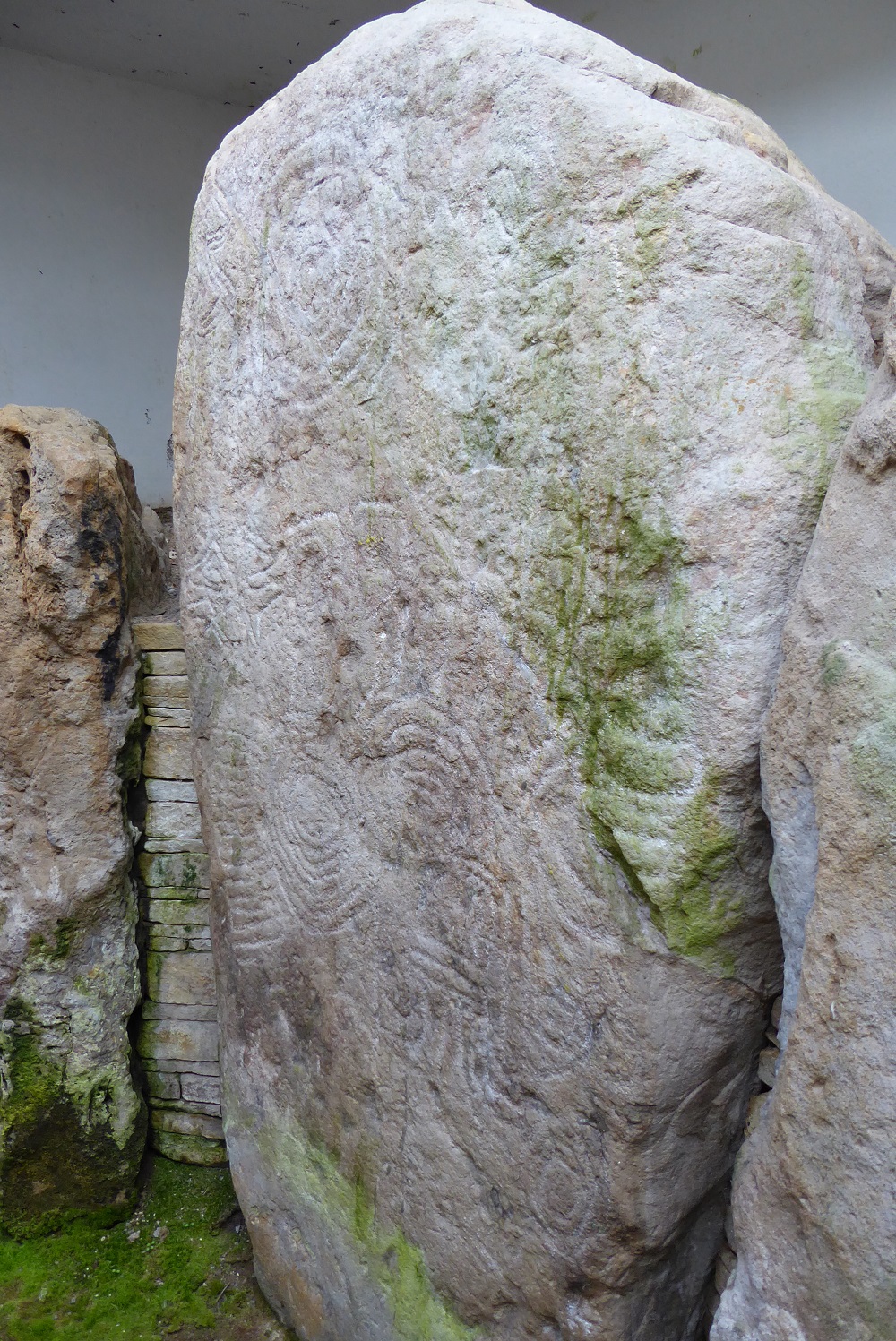
This was a complete surprise. Stopped off in Co. Tyrone to visit some old friends of the friend I was travelling to Donegal with. They just happened to know Mark Bailey the Director of Armagh Observatory who holds the key for Knockmany. He and his wife very kindly accompanied our small group up to the cairn which sits at the very top of a reasonably steep hill – commanding 360 degree views in all directions. Going inside the chambered cairn was a real thrill – my first close encounter with Irish rock art. Mark Bailey has the theory (a good one I should think) that the skies were once far more active in terms of comets and visibility that they appear to be now. And that the spiral shape with a ‘tail’ replicates a comet tail structure. We decided that the cairn was aligned north/south orientated due south towards Slieve Gullion and the Mournes. The cairn now has a clear glass covering and is not accessible without the key to the grill gate. However, most of the tomb can be seen quite well through the gate.


Sometimes Facebook throws up a delight. For a while now I’ve been linked up with a Facebook page called ‘Swindon – Past and Present’. A Swindon archaeologist by the name of Bernard Phillips has been posting some very interesting items about sites of archaeological interest in and around Swindon. Just read this about Barbury Castle:
“South of Wroughton, stands the Boroughs largest and most impressive Iron Age hillfort – Barbury Castle. Like Liddington Castle it was built around 750BC. Its double defensive ditches and ramparts enclose an area 11.5 acres (4.65 hectares). A geophysical survey in 1996 and an earthwork survey in 1998 by the Royal Commission for Historical Monuments recorded forty hut circles and hundreds of pits within it. Chance discoveries include a blacksmiths hoard that comprised knives, sickles, awls, spearheads, an anvil and a chariot fitting, and pits containing pottery and skeletons. The combined evidence points to this hillfort being dominant in the region serving domestic, agricultural, trading, military and religious functions throughout the Iron Age.”
An ancient and obscured piece of limestone has long guarded Cannon Street. It’s called simply London Stone (never ‘the’ London Stone). It might be a Roman milestone or druidic monument. Nobody knows. Very few people ever notice the venerable rock, which has long languished in a woefully unworthy niche opposite the station.
From this Friday, the mysterious artefact will finally get some attention when it goes on show as part of the the Museum of London’s War, Plague & Fire gallery.
London Stone was once much larger and more prominently positioned. The monument is mentioned in Shakespeare, and was first referenced in the 12th century. It is undoubtedly much older, and has been incorporated in the foundation myths of our city.
Display at the museum will finally bring London Stone back into public awareness after its long slumber. It will remain at the museum while work is carried out to rebuild its existing home.
The stone is shifting to the museum for temporary display, while its existing home is knocked down and rebuilt.
See London Stone at the Museum of London from Friday 13 May 2016. Entrance is free.
Great news! Scientist Mary Somerville too.
bbc.co.uk/news/uk-scotland-36111759
Robert Macfarlane, writer and Fellow of Emmanuel College, Cambridge, welcomed the choice of Ms Shepherd for the £5 note.
He said: “It is thrilling to see Nan Shepherd celebrated and commemorated in this way.
“Nan was a blazingly brilliant writer, a true original whose novels, poems and non-fiction broke new ground in Scottish literature, and her influence lives on powerfully today.”
insidewiltshire.co.uk/5000-years-of-history-unearthed-at-site-for-new-army-homes/
“The archaeological work that uncovered these exciting remains was undertaken as part of the normal planning process and we are pleased that, as a result, it has been agreed some of the most significant archaeology will be preserved within the planned open space. The remains date from the prehistoric to the modern periods and add new chapters to the story of Bulford. These finds are a great example of the fantastic range of archaeology that lies unseen under our county waiting to be rediscovered, and how sustainable development can help to tell us more about our past.”
A further phase of excavation is planned to examine the two prehistoric monuments beside which the Saxon cemetery was established. These appear to consist of Early Bronze Age round barrows that may have earlier, Neolithic origins. They are likely to be granted scheduled monument protection by Historic England and will be preserved in situ in a part of the site that will remain undeveloped. Neolithic pits outside the monuments contained decorated ‘Grooved Ware’ pottery, stone and flint axes, a finely made disc-shaped flint knife, a chalk bowl, and the bones of red deer, roe deer and aurochs (extinct wild cattle).
BOOZE will be banned from summer solstice celebrations at Stonehenge, English Heritage has confirmed.
And drivers will have to fork out £15 to park at the Stones, in a bid to reduce the number of cars at the event.
When the plans were unveiled in February it led to a “pay to pray policy” accusation from senior druid King Arthur Pendragon.
Bosses at Stonehenge say the reason behind introducing a £15 parking charge is encourage more people to car share and use public transport.
They also believe that banning alcohol will “reduce the risk to those attending and to the monument itself”. Drinking will not be allowed anywhere in the monument field.
Part of the reasons for the changes is the increase in numbers to Stonehenge for the summer solstice. In 2000, approximately 10,000 people attended while in 2014, the figure was close to 40,000. That same year, the stones were vandalised during both the summer and winter solstice celebrations.
Money raised from the new charges would go towards supporting £60,000 a year cost of maintaining the visitor centre car park. Kate Davies, Stonehenge’s General Manager, said: “Over the last 15 years we have seen a huge increase in the number of people celebrating the summer solstice at Stonehenge. We have limited parking facilities and we believe the parking charge will encourage more people to car share or travel by bus.
“We’ve also seen more drunken and disrespectful behaviour. Something has to be done or we risk losing what makes solstice at Stonehenge so special.
“These changes will help us to better look after both those attending the solstice and the ancient monument itself.
“Since we proposed these changes, we’ve had a lot of support from the public and from across all the different groups who help to organise the solstice celebrations.”
English Heritage also said it was mindful of how alcohol was used by some druids during ceremonial practice and would be consulting with the community on how moderate use of ritual alcohol.
English Heritage has commissioned a carving into the rocks at Tintagel. As this is the News Section I will refrain from expressing a personal view.
english-heritage.org.uk/about-us/search-news/merlin-carving-tintagel
Malmesbury, a Saxon town in north Wiltshire famous for its historic Abbey and it connection with the first king of all England, Athelstan. I was in the Athelstan Museum earlier today and was fascinated to learn Malmesbury is built on the site of an early Iron Age hill fort. Was looking at a 3D model of town in the museum and it is almost surrounded by two rivers. A town where prehistory becomes the history of England – life before the Normans. Also known as the “Queen of Hilltop Towns”.
bbc.co.uk/news/uk-england-wiltshire-35523757
“A Bronze Age cremation burial has been discovered near Stonehenge after being accidentally dug up by a badger. Objects found in a burial mound at Netheravon, Wiltshire, include a bronze saw, an archer’s wrist guard, a copper chisel and cremated human remains.
Experts believe the burial may have been that of an archer or a person who made archery equipment.
The artefacts date back to 2,200-2,000BC, senior archaeologist Richard Osgood, of the MOD, said.”
These will be displayed in the Wiltshire Museum at Devizes later in the year.
“A Druidical temple somewhat resembling that at Stonehenge in size and structure…The place is called Baltony, a name not uncommon in some districts of Ireland. It is supposed to be a corruption of Baal tinné, the ‘fire of Baal,’ — intimating a spot where that Deity was particularly worshiped in Ireland…Among the rigid Presbyterians of the North, such remains of antiquity are lightly regarded because they are deemed remnants of superstition and idolatry, although some respect has been paid to them by its respected proprietors.”
Mr. & Mrs. Hall, Ireland: Its Scenery, Character, etc., 18411