
Looking roughly north towards the back of the graveyard.
Image credit: ryaner
Looking roughly north towards the back of the graveyard.

The largest of these stones, about 1.3 metres tall.


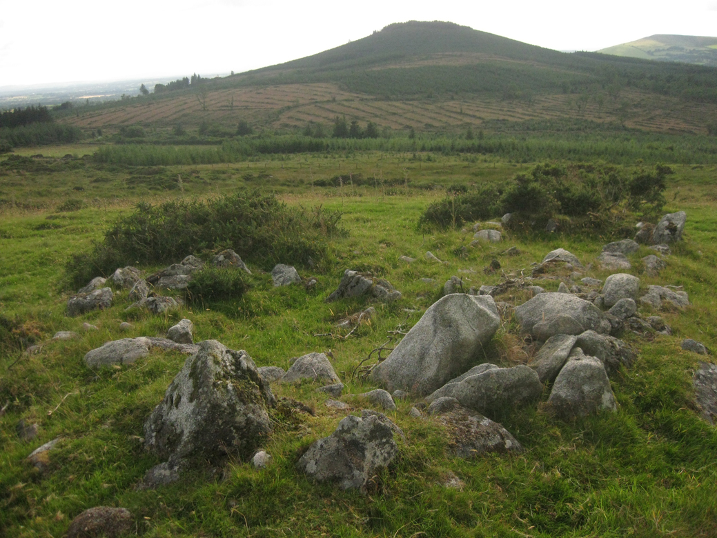
Long zoom shot from the cursus down to the neolithic enclosure with its hut sites on the lower western slopes of Keadeen.

Bad zoom shot of the cursus – you can just about make it out to the left top of the hill.

The dip in the middle foreground is the interior of the cursus.


From archaeology.ie:
Description: Clearly visible on Bing Maps (binged.it/19yShg9) and to a lesser extent on the 2000 and 2005 OS ortho imagery (maps.osi.ie/publicviewer/#V1,695140,689805,6,0). A long rectangular enclosure (L c. 286m; Wth c. 34m) defined by banks and running in an ENE-WSW direction on a steep slope, with a cairn (WI027-044----) just outside the NE corner. The banks (avg. Wth 5m; H 0.3-0.6m) which are probably constructed from the mountainside scree, are almost entirely covered in heather and sod, but in one place the stone fabric of the bank is fully exposed. While the remains are insufficient to allow classification with certainty, interpretation as a possible cursus monument would not be inconsistent with the surviving evidence.
Compiled by: Chris Corlett and Claire Breen
Date of upload: 25 June 2013
Date of last visit: 13 June 2013
References:
Corlett, C. 2014 Some cursus monuments in South Leinster. Archaeology Ireland 28, (2), 20-25.
See miscellaneous post.


Bracken shrouded Boleycarrigeen – the south-west arc looking south towards the Blackstairs.

Looking almost due south over the central mound of this extremely difficult to photograph monument. The mother’s breasts are Slievecorragh and Church mountain.


Said by some to be a hut-site at Keadeen enclosure, this is the site that Fourwinds believes is a stone circle, hence the delineation here.

Hut-site on Keadeen with modern additions, towards Colvinstown Hill.

North-west towards Brusselstown iron-age hillfort.


In Toor townland and neighbouring (to the east) Lugglass Upper, in a little glen north-east of the peak of Church mountain and almost directly north of Corriebracks, up through sheepy fields, surrounded by stones and mounds that could be, may be, a very neolithic environment vibe to it, there is this group of monuments.
This first part of the track is drivable but behind a farm gate. Just keep going up this track, stay undistracted by the banks, clumps, maybe fallen menhirs – keep going. I had the, as it turned out, fantasy that I might head up to the peak of Church mountain and over to some monuments on its western side – laughable notion in this heat.
After a while you come to another farm gate, directly ahead, not off to the left at the farmhouse where the standing stone is. Over this and about 100 metres in you must ascend the bank to your right. Up here on a flat, boggy plain, are the two stone circles and the henge.
The whole area is like a vast theatre gallery, with the gap between Slievecorragh and Church mountain the proscenium arch. Through here, way off in the distance to the north-west, there is one hill that pulls the attention of the observer, the Hill of Allen, full of Fionn MacCumhaill folklore. It really is quite a distance away, but on a clear day like the day I was there, it seems to float above the plain of Kildare, calling to the observer, attention seeking, and the star of the multi-faceted display up here.
At this, the southern stone circle, the flat face of the southern-most stone faces inwards, a big boulder; the next one on the arc towards the west is nondescript but again has its flat, shaped face facing inwards, today with the jawbone of a sheep on top and a sheep’s skull nearby. The westernmost stone leans in, again with the flat face facing inwards. The northernmost stone leans out, it’s flat face facing outwards. I think there may have been a sixth stone at one point.
The most eastern stone is almost buried, barely peeping out above the heather-covered peat. The interior is artificially flattened and again, it’s hard not to believe that there wasn’t another stone between the easternmost and northernmost stones, as that would suit the geometry of the place, but that sort of speculation can only lead one down to path to yet further contemplation of many more stones. In and of itself, this little known and small in stature circle is very near perfect.
Sitting here writing these notes I’m getting the yen to go back there already. As with all of the other sites here, the views are great, north-east towards Mullaghcleevaun, over the reservoir at Ballyknockan towards Sorrel Hill, again north-west through the gap towards the Hill of Allen. Sphagnum moss continues to grow in the interior and winter up here would be wellies’ terrain.
From the parking place directly south of the summit of Sorrel, on the road that comes up from Lackan, a track begins heading north that will bring you to the top. The path has been eroded/created by hillwalkers, a not very numerous bunch, but enough to wear away the ground. As I ascended I appreciated for the first time the majestic sweep of the curve created by the ridge of hills beginning at Sally Gap and Carrigvore and containing east to west Gravale, Duff Hill, Mullaghcleevaun east and west and Black Hill with Moanbane and Silsean over its back. North of here, but hidden by Sorrel itself, are Kippure, Seefingan and Seefin, Corrig and Seahan.
All over this side of Sorrel are many deep cut trenches into the peat, relics of turf-cutting, and as I ascend there are a few little stone structures that could be something, could be nothing. Further up, Tonduff appears through the Sally Gap and then Kippure. More trenches up here and one can’t help but wonder at the toil involved this high up – desperate times – though once the work was done, bringing it home was an easier downhill trek.
The summit of Sorrel is a flat, rubble-strewn wasteland of granite and sand, eroded, like the cairn it contains, by wind, rain and humanity. The view to the north really opens up now, and south-west over the reservoir are Slievecorragh, Church mountain and Corriebracks.
The cairn is wrecked, with people removing the lower stones and placing them atop, creating a different shaped structure with two distinct aspects. A lot of the exposed rubble consists of larger than normal boulders, leading one to think that much of the smaller covering material is now gone, revealing this more robust core. And it’s quite small, maybe 10 metres in diameter, looking bigger from a distance as it’s higher than normal with all the interference.
There is the sensation that you are at the centre of a bowl up here, with just the gap to the west and the reservoir, but directly west and lower is Lugnagun, with its tomb and cairn, compensating for the gap and furthering the illusion. The ridge that skirts the N81 at Kilteel, from Blessington to Slievethoul, closes the north-west view. There is a slight parallel here with the ring around Slieve Gullion and Calliagh Berra’s House.
The descent back down to the car is easy, the spring in your step aided by the new layers of sphagnum moss and the orchestra of chirping birds. There are other secrets on Sorrel Hill, but they’re for another day.

‘Enclosure’ or rath or barrow, down the road from the stone circle.
From archaeology.ie:
Description: Situated at the base of an elongated natural hollow. Circular platform (diam. 44m; H 2-2.5m) with a slightly dished summit (diam. 36m) defined by a partly natural, wide flat-bottomed ‘fosse’. No indication of a bank, entrance or internal features.
The above description is derived from the published ‘Archaeological Inventory of County Wicklow’ (Dublin: Stationery Office, 1997). In certain instances the entries have been revised and updated in the light of recent research.
Date of upload/revision: 17 December 2008
Date of last visit: 25 May 1989

Access to this is simple, 250 metres or so up a hillwalkers track at O125205 on the left-hand side of as you travel south on Military Road in the Featherbeds. For this reason I’ve been here many times, but never wrote about it until now.
Off the track about 5 metres into the peat is this wonderful stone, the connective evidence between bullauns and prehistory. There’s nowt else close by, the nearest early christian site about a mile below at St. Anne’s in the Glenasmole valley. Others have noticed an alignment here.
The stone is a big lump of granite, like a beached walrus, with 3 bullauns, 2 of which breach the south-east end. One of these two could scarcely be called a bullaun as it’s just a carved curve into the stone, but the density of the stone is very porous and all three basins seem to have eroded, and enlarged, over time.
Strangely enough, this stone is not marked on OS sheet 50, but is on archaeology.ie. I was first brought here by Fourwinds about 8 years ago.
Dublin City University have recently modernised and expanded their sporting facilities. There is an entrance on the Ballymun Road, just after the petrol station on your left as you travel north. Through here and around the back of the all-weather GAA pitch is the Poor Clares Convent. At the back of this is the mound.
I’m really surprised that the opportunity to excavate this site wasn’t taken before or during all the groundwork that happened recently. At the very least they could have cut down the sycamores that have colonised the mound, but that’s just me being selfish, wanting to open up this bit of urban prehistory.
Very hard to make out what’s under all the vegetation so I’ve added the SMR entry below. The height could lead one to speculate that it’s a Norman motte, but the diameter’s only 15 metres, so a tad too small for one of those. Great that this still survives amongst all the urban sprawl, though really only one for the completists.


The mound is in the trees direct centre of the shot.
From archaeology.ie:
Description: Situated in the grounds of the Poor Clare convent (formerly Claremont Institution). Comprises a round-topped mound with steep sides (H 4m; diam. 15m). Views from the top are of an extensive low-lying plain, which today is occupied by housing estates. Overgrown with thorns and sycamores. The W and NW sides have been damaged.
Compiled by: Geraldine Stout
Date of upload: 26 August 2011
Date of last visit: 08 June 1994


I approached this site from the bottom of the cliff in Hollywood glen at N934024. There is a small waterfall on the east side of the road that runs through the glen and just beside this is a pumping house. Directly opposite this you can see a track up towards the cliff-top. It is extremely steep and arduous.
This is called a rath here but I’d say promontory fort would better describe it. It’s D-shaped, with the straight line of the D to the east and the maw of the cliff. It’s maybe 40 metres north-south, but the ditch, where it can be seen below the vegetation, is impressive. There are some earthfast boulders peeping out of the structure of the defences but it’s hard to say what the bank is made from. Allowing for silting over time, I’d say possibly 3 metres in places from bottom of ditch to top of bank.
There are no traces of any structure inside the small area of the fort, which has space for one homestead. Did the people who lived here, if this was a habitation site, build the stone circle below? The views west down to the N81, where traffic blasts noisily by, and across the Kildare plain are great. North-north-east the cairn of Slievecorragh is visible.
The long axis of the standing stone, almost NW-SE, points NW directly at the stone circle below. South-east is the peak of Church mountain with its cairn, though this is not visible from here. There is a handy stone placed at the base of the standing stone, probably used as a comfortable viewing seat with the narrow axis of the stone as a backrest, to look down on the stone circle. The stone now leans to the north-east. It’s over a metre tall.
On the walk across from the road to the habitation site and cairn cluster, we took the more modern, sandy track which at first goes east-west, then veers north-south to the top of the hill. This track is littered with quartz stones of varying sizes. As the track changes direction, it becomes necessary to leave it behind and head across the moor, most of which is littered with various scatterings of stone, natural and man-made.
At the most easily identifiable hut-site in Piperstown, the door is in the southern wall (just slightly east of south). From front to back it’s 7 metres or so and six from side to side, not square but almost. In the 5 times I’ve visited Piperstown previously I missed this every time, even though it is plainly obvious – I guess you have to know where to look, though we just happened on this today (16/6/14). There are other hut-sites scattered on the hillside but none of the same quality, as far as I could see.
We moved on to the cairn cluster. These are still very visible. They are all in an area of about 120 mettes by 15 metres. The fire burnt away the vegetation and the summer last year was so hot and dry that it turned much of the peat to dust. There is the line of 4 cairns that are more or less aligned north-south. The bottom, most southerly is showing much of its mass, about 6 metres in diameter, but low and with no kerbstones visible.
Midway between this first and the second to the north is a large lump of earthfast stone. The second cairn itself has a most definite kerb, best preserved from the south-east to the west and this is the largest of all the cairns at Piperstown, maybe 8 metres in diameter. Just slightly south-west of this cairn, and out of the main line of four, is another very small, low cairn, and beyond that, directly west is yet another.
Further up to the north is a very denuded and low cairn, and then beyond that, the last of the line and the most ‘famous’ one, mentioned in Burl’s gazetteer as having a circle of stones, an interpretation arrived at after the cairn was excavated and found to have a number of small standing stones surrounding it. These stones are still visible, and unlike the ‘body of the cairn which consists of granite boulders, are of a greywacke type of stone. The cairn is tiny, maybe a little over 2 metres in diameter, but is the most cairn-like of all the sites on Piperstown.
It’s quite striking how suitable that Piperstown is for habitation, a low, flattish hill, but still prominent enough to dominate its immediate surroundings. West of here is the passage grave cemetery of Seahan/Seefingan/Seefin and this massif, like at other habitation sites in the area, seems to watch over the place, the ancestors guarding the inhabitants.
A long, ovoid barrow, aligned roughly north-south on its long axis. A very defined ditch remains on the southern end and western flank, dug into on the eastern side. This monument is more like a stepped barrow, or a rath, but not in the shape of this last type. It’s 40 or 50 metres long, by 10 or 15 wide, and the ditch is faintly visible on the east side as well. Hawthorn trees colonise the spine. There is the possibility that this is two conjoined barrows with the one fosse.
Were it not for the modern road that splits them, with its banks and trees, Kinsellastown long barrow, and Crehelp round barrow would be intervisible, Kinsellastown raised on a hill to the south of Crehelp. A line between the two would point towards Baltinglass and just miss out Spinans Hill.
The standing stone is about 5 or 600 metrtes west of the long barrow. Over a metre and a half tall, in a pasture field, on the crest of a knoll that falls away to the west and south. There are deep grooves in one corner of the square-profiled stone that sits down in an eroded pit, 4 metres in diameter and about half a metre deep. This hides the base of the stone as you approach. Church mountain and Slievecorragh dominate the eastern skyline.
Utterly fascinating ring barrow, absolutely stunning as you peep over the bank and there she sits in her perfection. To the south the terrain rises suddenly, forming a kind of tangential platform to the barrow, provoking speculation that these ‘barrows’ are not barrows, but ceremonial henges of some sort. This is one of a few of this type that I’ve seen in and around Blessington with very flattened interiors, almost as if they were designed that way – if they never contained burials, then what was their purpose?
The external ditch, 20 to 25 metres in diameter, the bank, down again in towards the centre covered in rushes and with no signs of a cist or any structure, just a bit of a depression. This site must trap water in the winter, allowing the rushes to grow – it’s not naturally marshy here, quite dry really for a place with such an abundance of rushes. On the northern arc is a rabbit warren dug into the bank, east is a house and back garden with the resident mowing the lawn.
To the south and south-east, Keadeen and Brusselstown are really prominent. Trees block the view east towards Church mountain, but she’s there alright.
This wonderful barrow is at the top of a hill north of Slieveroe, west-north-west of Blessington. The tiny boreen that gives access to the field is almost impossible to park on. Below the hill and to the west, there is a space with enough room for one car, but it’s very tight so I wasn’t comfortable hanging around in case a farmer with his tractor happened by.
About 250 metres south into the field and up, the line of an old field boundary becomes visible. Directly behind this is the ring-barrow (the SMR classification). There is a raised area at the centre, but given that there is also an entrance through the bank and fosse at the east, you could be forgiven for thinking this is a ceremonial henge rather than a burial site.
The views from up here are stunning, even with the dank, low cloud – Sorrel Hill, Black Hill, Moanbane and Silsean to the south-east over the reservoir all look magnificent. North-east is the plains of Kildare. I hadn’t the time that the place deserves, but was very taken by this monument.
I had tried to get to this stone a couple of times before, giving up because of the necessity (as I understood then) of traversing much private property. However, there is an ancient sunken lane that passes along the side of one of the bungalows and up to an old farmstead and behind this to the right is the monument.
On the day I visited there was livestock in the field, but except for one cow, they mostly just ignored me. The blocky stone is large, well above average in height, girth and bulk. There are about 14 cup-marks on the southern end of the western face. Even though it’s in a pasture field, it’s still pretty wild around here – the ground rising to the east towards untamed moorland. Another Dublin megalith, south of Verschoyles Hill.
Having had poor luck finding the standing stones south-west of here (they’re mostly destroyed), I hadn’t much hope heading back into Cork down this road. Unawares, I had already passed one stone and a massive rath and had half decided to give up when on glancing into a football field on my right I spotted this, admittedly hard to miss, giant.
There was a man jogging laps of the pitch, and a couple of kids hanging out around the truck container changing rooms, and there was me, snapping away, completely enchanted by the incongruous siting of this stone (of course it’s not the stone that’s out of place – it was here first). The man stopped his exertions to ask me if I knew what I was photographing – a standing stone says I, a gallán said he.
This almost triangular stone was once one of a pair (see below) and towers over 3 metres tall, almost tapering to a point as it rises. There is one cup-mark high up on its eastern face. Quite a strange prospect, standing there on the touch-line, waiting for its game.
Not dissimilar to its near neighbour, but now isolated in a pasture field on the other side of the local authority housing estate. The SMR record says that this is only visible on aerial photographs, but this is most definitely incorrect. It’s there alright, robbed-out mound, bank, fossse, the whole shebang, nestling above a gully on its southern edge, and overgrown with nettles at this time of year.
I scouted around a while, attempting to get a half-decent shot of the monument, and failing dismally. I might drop back in the winter as access is extremely easy at the west end of Blessington town.
OK, so a confession first – I’ve visited this site about 5 times before, and photographed it each time. I’ve never posted it as I’m not convinced of its provenance. It is marked on the SMR at archaeology.ie and this chap megalithicmonumentsofireland.com/COUNTIES/DUBLIN/Kiltalown_StandingStone.html is convinced, so here it is.
It’s deeply embedded in the soil and has been used very recently as a fairly permanent memorial. I get the feeling that when it was pushed over, an attempt was made to smash and bury it. One for the completist only, but I’m glad to record it.
This site is actually visible from the N81, down on the right-hand side as you enter the town of Blessington from the north, opposite the Topaz garage and behind the Aldi.
When I stumbled upon it and saw its current situation beside a childrens’ playground I laughed out loud. I climbed the tallest climbing frame to take a few snaps, explaining to the mother and her child about the 3,000 year old burial mound.
Absolutely fascinating that this is still here – they even diverted the road around it. It’s quite overgrown at the moment, rose-bay willow herb colonising the southern end, but the fosse and bank are still very visible, with the centre of the mound quite flat, either robbed of some of its material or designed like that. (A lot of the barrows hereabouts have similar problems)
This one is a survivor, lying there as the hustle and bustle of a busy town goes on around it, bang in front of your face and invisible. Great.
4 or 500 metres beyond the entrance to the field with the 6 basin Kilbeg bullaun stone is a small hill-walking track, Pound Lane. It has its own signpost and is an Agreed Access hillwalkers pathway. It leads up Black Hill and in a broad loop back over to the parking place directly south of Sorrel Hill.
Not long after moving above the last enclosed field, it passes through an area called Whelp Rock – this is where the standing stone is. Were it not precisely marked on the archaeology.ie map browser I would never have found it.
From the west the stone has a triangular aspect – this face is also quartz encrusted. The long axis is NNW-SSE and points directly at the passage grave on Lugnagun.
There are many, many stones scattered about the hillside here, with some old booleying sites, and there is that ancient feeling about the place that makes one feel that it could bear more serious investigation.