
Ditch on the inner side of the eastern banks of the cursus.
Image credit: ryaner
Ditch on the inner side of the eastern banks of the cursus.

Eastern ridges of the Banqueting Hall cursus on the horizon line.


The entry for this stone on the SMR at archaeology.ie:
Class: Rock art
Townland: BALLINVALLY
Scheduled for inclusion in the next revision of the RMP: Yes
Description: This large erratic (dims c. 2.6m x c. 1.5m; H 0.95m at E, uphill, to 1.95m at W) is located on the steep NW-facing slope of Patrickstown Hill. It has art on its upper surface, which is divided in two by a crack, and it has been fully recorded by Shee Twohig (et al. 2010, 16). The N part has three concentric circles, while the S part has a motif of three concentric circles with a central dot connected by a line to a large, central, set of four or five concentric circles (diam. 0.7m). There is a third small concentric circle in the N part.
Compiled by: Michael Moore
Date of upload: 3 March, 2017
References:
1. Shee Twohig, E., Roughly, C., Shell, C., O’Reilly, C., Clarke, P. and G. Swanston 2010 Open-air rock art at Loughcrew, Co. Meath. Journal of Irish Archaeology, vol. 19, 1-28.

Some cup-marks. (see misc. entry for full details)


The ‘passage’ looking towards Carnbane East and Cairn T in the distance.

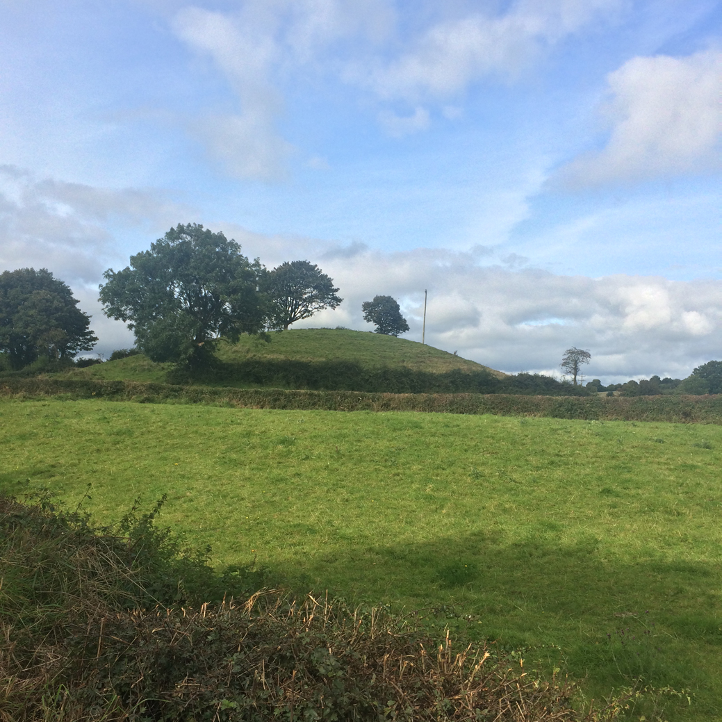
The good, northern, side of the mound, really looking like a small hillock or drumlin from here.

The top of the mound. There is evidence here that the mound is man-made, the light soil covering what appears to be classic cairn rubble.


A quarter of the mound seems to have been chopped out, revealing the chamber of an undifferentiated passage grave, but I’m not convinced given there were no signs whatsoever of a kerb.


Small roadside barrow. Had to scarper as there were dogs a-barking, hence the crap quality shots.


If this is what they say it is – the remains of a passage grave – then it is of the undifferentiated variety, and diminutive at that.
From the very small road and over the fence, south about 150 metres into the field and very visible is a hillock, about 3 to 4 metres tall. This is very possibly man-made. Exploring around it’s top there seems to be cairn rubble remaining. Maybe, when the excavators realised that they had disturbed an ancient grave, they had second thoughts and stopped their handiwork. But not before they had scooped out a sizable chunk of the southern side of the mound, revealing the chamberless passage.
What’s left of this speculative passage are about 12 stones, most in an alignment onto cairn T in Loughcrew, with the most south-easterly pair forming an ‘entrance’. Alas, were this an entrance, the alignment of the tomb would face away from Cairn T which would be behind the tomb to the north-west. So quaint theories may be just that, quaint but wholly incorrect.
All of the tombs on the hills of Loughcrew either align with other tombs to the east, or with the equinox sunrise in the east, so this ones orientation doesn’t exclude the possibility that this is a Loughcrew outlier, along with the mound at Bobsville graveyard with its megalithic art another kilometre to the south.
The Banshee Lives in the Handball Alley
The Banshee Lives in the Handball Alley is a short compilation derived from a larger collection of folklore recorded in three primary schools in Limerick City as part of the Cuisle Poetry Festival and Young EV+A in 2004 and 2005.

The south-west one of two cairns within the ancient Templefinan Graveyard and enclosure.

Endlessly fascinated by this monument, its durability and its location. Early January, 2018.


More serious problems at Dunbeg.
Full story:
thejournal.ie/kerry-fort-ancient-3781702-Jan2018/
The prehistoric shift towards cultivation began our preoccupation with hierarchy and growth – and even changed how we perceive the passage of time
[T]he National Folklore Collection UCD, [is] an institute recognised as one of Europe’s largest archives of oral tradition and cultural history. Visitors to the Collection are invited to explore a large selection of books, manuscripts, audio recordings, videos and photographs, drawings and paintings dealing with Irish life, folk history and culture.

The ‘ring cairn’ from 4 metres up on top of some stacked straw bales. There are many substantial stones here, but the whole mess seems almost like a clearance cairn.


Contiguous kerbstones on the northern arc of the ‘barrow’.
We all want to believe that the places and heritage we love will be protected by somebody else for our children to enjoy. Some really important places in the UK benefit from protection by law and are supposed to be kept safe by our government bodies for the benefit of everyone. One such place is the ancient Neolithic burial site on the hill at Knock Iveagh. Although the burial site (cairn) is older than the pyramids and should be treated as a gem in the crown of beautiful Co Down, right now unfortunately it looks like somebody has dropped the ball because it is under terrible threat. Our public bodies have the power to save the hill and it is up to us to make sure they do so. That is why we are asking for your contribution to this important fight. Legal advice costs money, but this is a fight we can and must win.


It’s hard to know which is what here at the very ruined tomb in Corduff South. At the roadside over a fence and ditch, and overgrown and neglected, I can’t imagine anyone but the most diehard of stoneheads ever visiting this sad place... and yet, there is a strange beauty here, one that we who follow traces appreciate, a dignity, a celebration of what once was.

From archaeology.ie:
Class: Megalithic tomb – wedge tomb
Townland: LOUGHSCUR
Scheduled for inclusion in the next revision of the RMP: Yes
Description: Situated on a slight rise in pasture in a broad E-W valley with the W end of Lough Scur c. 0.25km to the ENE. This is a rectangular structure (dims 7m E-W; c. 2.7m N-S) of which only the S and part of the W sides survive. It is composed of contiguous orthostats (max. dims 1.2m x 0.2m; H 0.5m) with some displaced stones (max. dims 1.5m x 1m) present. The stones are situated on a grass-covered mound (basal dims 17m E-W; 12.5m N-S; H 0.5m at E to 1m at N).
The above description is derived from ‘The Archaeological Inventory of County Leitrim’ compiled by Michael J. Moore (Dublin: Stationery Office, 2003). In certain instances the entries have been revised and updated in the light of recent research.
Date of upload: 23 September 2008

Very little left here, but I was still glad I took to trouble to visit.

300m north-west of the more famous portal tomb are the scant remains of a supposed court or wedge tomb (I’d say wedge).

Once upon a time they gave this one its own gate, pathway and courtyard.

The capstone, under its own immense weight, has disintegrated into four pieces and collapsed into the chamber.


Some of the disturbed structure of the monument seems to be collapsing down the hill/drumlin.


Kerbstones visible on the south-east arc of the ring.

Some cairn material is visible at the overgrown site.
From archaeology.ie: This has been described by Eogan (2000, 11-13) as follows: ‘This is also situated on a knoll and is very overgrown. The knoll, which is much higher than the adjacent features, is rounded and somewhat pudding-bowl in shape, and as such it contrasts with the other knolls in the area which are long Bakers. In Prof. Phillips’ opinion it is “probably a kame deposited in a lake by melt water flowing out from a glacier during the last ice age c. 22,000-14,000 years ago.” The view is slightly more extensive than that from Site 2 [ME010-044----] and portions of Slieve na Calliagh range are visible. This almost circular monument, 26 by 25m in external diameter, has thirty-seven stones, thirty-one being in their original positions. If the gaps are filled, then about nineteen stones are missing, and this would have made a total of about fifty-six stones.
Externally, 7m to the south-west, there is an isolated stone (No. 12a). This may have been a removed kerbstone. Internally there is a somewhat curved depression towards the centre. Within it, or close to it, are four stones in a disturbed position (Nos. A-D). Apart from No. A, these are not sufficiently large to have served as orthostats or capstones, so their function has not been established. However, it is possible that this might be the chamber area. The other portions within the circle have a spread of smallish stones, possibly lm or so in height. There are also some smaller stones outside the kerb. No art is visible. Professor Phillips reports that the materials of the stones are as follows:
A – Well bedded limestone with shale partings. This rock type can be found as bedrock along the River Black water between Kells and Navan. B-D and 1-37 – All these stones are composed of massive greywacke (Silurian age) which is often coarse grained and cleaved. Several stones contain elliptical calcareous concretions. This rock type is well exposed as bedrock on the hill of Carrigasimon above the north side of the River Blackwater, upstream from this site.’ (Eogan 2000)