

The stone seems to have escaped relatively unscathed from the recent fires.

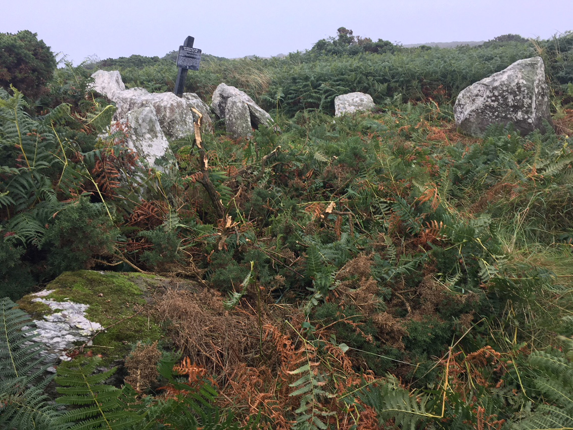
It’s hard to say what this once was, but my best guess is a wedge tomb.

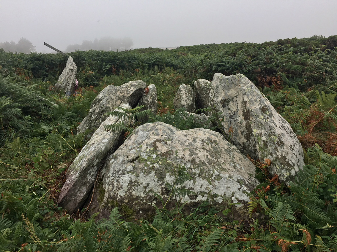
Over the top of the larger stone is the standing stone in the distance.

From this angle it could be the remains of a megalithic tomb.

From here it looks like a classic stone pair.

Over the shoulder of the stone is the ‘anomalous stone group’.


Aligned NNW–SSE on its long axis.

According to the Archaeological Inventory of County Cork, Vol. III – Mid-Cork, Anomalous Stone Group are: “… groups of stones, usually standing, which do not appear to conform to any known archaeological site type; an example might be pairs of standing stones set parallel to or contiguous with one another, instead of the usual arrangement of stone pairs. Some may just be fortuitous groups of stones of a random or natural state but others are likely to be remnants of partially destroyed or obscured archaeological monuments.”

Another view into the front of the small chamber.

Looking south-west over the whole monument.

Looking down at the backstone of the chamber.

From the back of the monument. The chamber is missing a roofstone/lintel at the very back.

The supposed chamber with roofstone. Bracken inundated the site.

Pano of the ‘tomb’ location. The hill is steep and the monument is in the bracken to the right of centre-shot.

Looking at the ‘tomb’ from outside the front of the so-called court.

Often referred to as Coolnasmearamountain, this is actually in the neighbouring townland of Bohadoonmountain.

I’ve seen shots with the smaller stone standing beside it, but I’m not too sure of the provenance. could be just a bit of field clearance.


Bulky standing stone in Bohadoon Mountain townland.


Much disturbance but very little signs of structural stones or a kerb.


The standing stone is right beside a track, easily found 150 metres in from the road.


South-west towards the Colligan River valley.


North-east towards a spur of Farbreaga.


Looking north along the passage towards the steps and the ‘entrance’.


Another of Waterford’s amazing sites left in a disgraceful condition, overgrown with nettles and thistles. We approached from the west, through an open gate and down a farm track. I wasn’t sure that we had found the right place until we were right on top of it, the substantial standing ogham stones hidden by the summer growth.
Once again I had a go at tidying the place up, giving the stones a bit of breathing space. The enclosure is in a large pasture field on a working farm and you would wonder had it had any visitors this summer. The monument is in state “care” but with the nearby Waterford Greenway now very popular, could this care not be more actual than theoretical?
Five stones stand at the edge of the cut of the souterrain, all former lintels or roofstones of the reasonably short passage. Steps lead down into the passage where more ogham stones line the sides. There are three unmarked roofstones remaining over the passage, two almost midway down the passage and one over the end of the souterrain. Most of the passage is made up of dry-stone walling.
Even with all the herbage, the power of this place couldn’t be dimmed. I was affected by the stones here and the remnants of the souterrain more than I would be at a lot of the ‘show’ sites along the Tramore dolmen trail. Which is not to say that I’ll be back anytime soon, if ever – but who knows?
From archaeology.ie:
Description: Discovered during the removal of the outer bank of church site (WA024-033001-) at N in 1868 (Williams 1868-9). Rectangular chamber (dims. 3.35m x 1.5m; H at discovery 1.2m) with orthostatic walls and roofed with eight lintels. Ten ogham stones (WA024-033006- to WA024-033015-), which were utilised as lintels and sidestones, are preserved at the site.
The inscriptions have been read by Macalister (1945, vol. 1, 267-77) as: 1, MANU MAGUNO GATI MOCOI MACORBO; 2, CALUNOVIC[A] MAQI MUCOI LIT[ENI]; 3, MAQI-INI[...MAQI QE]TTEAS; 4, CUNALEGEA MAQI C[...]SALAR CELI AVI QVECI; 5, BIGU MAQI LAG [...]; 6, BIR MAQI MUCOI ROTTIS; 7, ...] MAQI NE[TACUN]AS; 8, DENAVEC[A MU]COI MEDALO; 9, BRO[INION]AS; 10, SOVALINI/ DEAGOS MAQI MUCO[I...]NAI. (Brash 1866-9; Rhys 1899; Kirwan 1985; 1987; Harbison 1992, 325)
The above description is derived from the published ‘Archaeological Inventory of County Waterford’ (Dublin: Stationery Office, 1999). In certain instances the entries have been revised and updated in the light of recent research.
Compiled by: Michael Moore.
Date of upload/revision: 9th May, 2011.
This monument is subject to a preservation order made under the National Monuments Acts 1930 to 2014 (PO no. 12/1933).
References:
1. Brash, R.R. 1868-9 On the Seskinan ogham inscriptions. County of Waterford. Journal of the Royal Society of Antiquaries of Ireland 10, 118-30.
2. Harbison, P. 1992 The high crosses of Ireland: an iconographical and photographic survey, 3 vols. Dublin. Royal Irish Academy. Bonn. Dr. Rudolf Habelt GMBH.
3. Kirwan, E.M. 1985 The ogham stones at Drumlohan reconsidered. Decies, no. 29, 6-12.
4. Kirwan, E.M. 1987 Drumlohan: a survey of its antiquities. Decies, no. 35, 33-40.
5. Macalister, R.A.S. 1945 Corpus inscriptionum insularum celticarum. Dublin. Stationery Office.
6. Rhys, P. 1899 The Drumloghan ogams. Journal of the Royal Society of Antiquaries of Ireland 29, 390-403.
7. Williams, W. 1868-9 On an ogham chamber at Drumloghan, in the County of Waterford. Journal of the Royal Society of Antiquaries of Ireland 10, 35-9.

The bank of the habitation site of the souterrain builders is visible beyond the fence.
From archaeology.ie:
Description: Located in a fold on a steep W-facing slope overlooking a shelf on the E side of the ravine of the N-S Araglin River, with the stream c. 400m to the W. This is a wedge-shaped chamber (L 1.45m NE-SW; Wth 0.6m at NE to 0.8m at SW; H 0.5m) roofed by two lintels. The SE wall has two orthostats and some drystone walling, but the NW side is constructed entirely of drystone walling, apart from one upright at the SW end. There is a single backstone at NE. The chamber opens into a court (dims. c. 4m NE-SW; c. 2.8m NW-SE) defined by drystone walling with some uprights that are not set in the ground, and the court is likely to be a secondary feature.
Compiled by: Michael Moore. Date of upload: 6th May, 2011.
From the eastern arm of the court. This side is being inundated by gorse.


From the end of the western arm of the court, after tamping back the bracken and brambles.

Jamb stones at the gallery entrance. There’s a sill-stone there too.
