
Is this a brilliant stone or isn’t it? The colours vibrating off the screen – and look at that Ogham! More at users.skynet.be/bert_saskia/travel/ireland/
Image credit: Bert Timmermans
Is this a brilliant stone or isn’t it? The colours vibrating off the screen – and look at that Ogham! More at users.skynet.be/bert_saskia/travel/ireland/
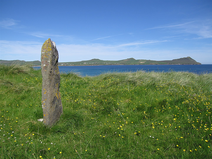
Ballinrannig setting, with Smerwick Harbour and the Three Sisters (An Triúr Deirféar) in the background. More at users.skynet.be/bert_saskia/travel/ireland/

From inside one of the beehive huts (clochauns) towards the blue good. More at users.skynet.be/bert_saskia/travel/ireland/

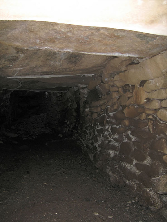
I’m obsessed with souterrains. This is a small collapsed one in the southern ditch (which is itself a souterrain). More at users.skynet.be/bert_saskia/travel/ireland/

Magnificent Caher Conor setting. Brilliant Dingle Bay and Macgillycuddy’s Reeks (Iveragh) backdrop. The 5th of June 2006, and I can still feel the early summer sun on my memory, the space gently prying my head open. More at users.skynet.be/bert_saskia/travel/ireland/

And again a bit further from the entrance, but southward. No, I didn’t see this space except on the photos. More at users.skynet.be/bert_saskia/travel/ireland/
The souterrain a bit further away from the outer wall entrance, north again. More at users.skynet.be/bert_saskia/travel/ireland/

Again towards the north. How to get there? Impossible; simply stick the camera in the cracks... as shown :-) More at users.skynet.be/bert_saskia/travel/ireland/

Souterrain again at the same spot, but towards the north. More at users.skynet.be/bert_saskia/travel/ireland/

This is the pretty huge souterrain structure under the flagstones leading to the entrance; towards the south (spider eggs!). I luuurve souterrains, which is probably what made me take up speleology recently. More at users.skynet.be/bert_saskia/travel/ireland/

The outer wall on the inside. Nice stone work I’d say! More at users.skynet.be/bert_saskia/travel/ireland/

Looking out from the niche in the outer wall – where it is brilliant to meditate! – towards the big beehive structure. More at users.skynet.be/bert_saskia/travel/ireland/

Flagstones leading to te main entrance (see other pictures for the souterrain underneath!). More at users.skynet.be/bert_saskia/travel/ireland/

Magnificant Dunbeg setting, with Dingle Bay and the hills of Iveragh in the background. More at users.skynet.be/bert_saskia/travel/ireland/

Metamorphic rock with an identity problem thinks it’s wood. Well it won’t grow, someone should tell it that. More on users.skynet.be/bert_saskia/travel/scotland/hebridesandmainland/outerhebrides.htm

The most elegant of the batch. More on users.skynet.be/bert_saskia/travel/scotland/hebridesandmainland/outerhebrides.htm

Inside the broch wall, on the stairs leading to the first floor. More on users.skynet.be/bert_saskia/travel/scotland/hebridesandmainland/outerhebrides.htm

Inner court with the intact double wall. More on users.skynet.be/bert_saskia/travel/scotland/hebridesandmainland/outerhebrides.htm

The broch’s spectacular setting looking over the small Loch an Dùin and beyond it the sea with Loch Rog an Ear – views all the way to the Harris hills. More on users.skynet.be/bert_saskia/travel/scotland/hebridesandmainland/outerhebrides.htm

Upclose for the texture of it. Brilliant piece of stone. More imposing with each step closer. More on users.skynet.be/bert_saskia/travel/scotland/hebridesandmainland/outerhebrides.htm

The plan of the settlement as it can be found at the site, indicating the three different building periods. According to the Orkneyar site, the white is what it must have looked like around 2600 BC. Cosy. More at users.skynet.be/bert_saskia/travel/scotland/northernatlantic/index1.html

The full Brodgar Ring from the Comet Stone to the west. The light looked evil. More on users.skynet.be/bert_saskia/travel/scotland/northernatlantic/index1.html

The big slab up close with the midday sun on it. The sheer height, unbelievable texture, and crisp light of this northern sky give you vertigo before you know it. More on users.skynet.be/bert_saskia/travel/scotland/northernatlantic/index1.html

The Watchstone seen towards the Standing Stones of Stenness with Ward Hill backdrop. More on users.skynet.be/bert_saskia/travel/scotland/northernatlantic/index1.html
We were there in July 2004. Couldn’t fit a Mousa boat trip in our schedule, so under a ridiculously blue sky drove south the A970 to Leebotten (where the Mousa ferry leaves), then further to Sandwick, then taking the small road that leads up to Ward of Burraland hill. At the end there was some space to park the car. Walked back down some 100m then took the first track right to Mousa Sound. Before long the track turned right alongside the sound and onward to some ruins which seemed pretty recent. A bit further was an istmus leading to a mini peninsula named Hoga according to the map. The broch is mainly in ruins, though the double wall can clearly be seen. The floor seems to have collapsed as there’s a depression in the centre. Around, there’s some evidence of other buildings. The setting is stupendous, the birds, the quiet – Shetland. Got good views of the Mousa Broch. Then suddenly it struck us that there must have been living some pretty advanced folk here. If so many people could have lived here for so long, than, considering it’s just as far to Norway as it is to the Faroes, as it is from there to Iceland, from Iceland to Greenland... yep, it is very well possible we thought, that these people actually set foot in the Americas ages before the Iberians...
The only piece of information I readily found was “Mousa broch is smaller in diameter than most, and today there is no sign of any surrounding structures apart from a possible rampart. Across the sound its neighbour, Burraland broch, does have evidence of settlement around it, but awaits further investigation.” (from orkneyshetland.co.uk/shetland/mousa.html) and some stuff that I can’t access at scran.ac.uk/database/results.php?search_term=burraland (Burraland loch is somewhere else; there’s a lot of burra on Shetland)
More on our 2004 Shetland stay: users.skynet.be/bert_saskia/travel/scotland/northernatlantic/index2.html

Standing on the western wall of the broch, looking over the eastern walls to Mousa and Mousa Broch (under the red pointer). It can clearly be seen that both brochs had complete control over Mousa Sound and sweeping views. They could in principle guard each other’s backs. On the left beyond are the isles of Bressay and Noss (the peak). More on users.skynet.be/bert_saskia/travel/scotland/northernatlantic/index2.html

View on (the ruins of) the Burraland Broch, to WNW (behind me is Mousa Sound). More on users.skynet.be/bert_saskia/travel/scotland/northernatlantic/index2.html

The broch courtyard with the ‘aisled’ roundhouse in which wheelhouses and the rest of this village-like structure. Almost broke my neck hanging over the edge of the Laird’s House. On the far right part of the Norse settlement. Water beyond is the West Voe of Sumburgh. More on users.skynet.be/bert_saskia/travel/scotland/northernatlantic/index2.html

One of the extremely cramped Iron Age souterrains at Jarlshof (the most northerly one), view towards the entrance. About 1m in height, 3-4 m² – so, much smaller that the Grain Souterrain on Orkney. Only comparison standard is the tip & heel of my size 8 1/2 footprint near the entrance. Agreeably cool, but utterly humid. I couldn’t manage to squeeze myself in the other, so no pics there. More at users.skynet.be/bert_saskia/travel/scotland/northernatlantic/index2.html