
A hut in the settlement that lies on the south west slope of the Tor.
Image credit: Peter Castle. ©
A hut in the settlement that lies on the south west slope of the Tor.

One of the many huts scattered on the west side of Littaford Tor just outside the east side of Wistman’s Wood.
This is one of the much modified cairns in this area, this one being more modified than others in that it once had a house on it , the cairn being 20 metres in diameter. Legend has it that the house was lived in by a clock maker although some say he was more likely to have been a peat cutter.

Western White Barrow lies aproximately 1 kilometer to the west of Eastern White Barrow. This cairn has been modified by walkers and had a cross , some of which is left and can be seem centre right of the photo, erected on it in the 1500’s.

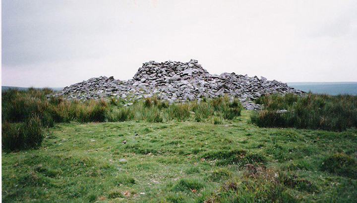
The cairn sits on a hill high above the Avon Dam and is prominent on the skyline . It is one of many cairns in the area that have been modified by walkers who do not realise the cairn are listed monuments.

Members of the D.P.A team surveying one of the many shelters built into the summit barrow, before restoration.

The reave that runs through the summit barrow , looking from the north west towards the summit barrow

The reave that runs through the centre of the summit barrow ,looking north west from the summit barrow. The reve stops for no apparent reason in the distance, almost centre of the photo.

Looking up the reave that runs across the plateau with the three barrows on it ,from the south east towards the summit barrow, which is just out of shot. The barrow seen is the southerly one of the three and the reave just clips it’s west side.

The reave which runs south easterly from the summit cairn. looking south easterly. The reave can be seen snaking away to the left where it stops at the tin workings around the West Glase Brook.

The “Tolmen Stone” on the North Teign approximately 400 metres to the south of the circle . This is a large stone set in the river bank and an adult can easily fit through the hole , being around 3ft in diameter. According to legend if you pass through the hole it will cure you of whooping cough and/or arthritis . You can see that others are starting to form.


Part of the north west wall of Boringdon Camp. Shaugh Moor can just be seen in the background.

Boringdon Camp looking from the west towards the original entrance.

Boringdon Camp Looking north towards Dartmoor.

A photo of the aerial photograph on one of the information boards.
The original entrance is now covered by part of the woodland and was in the top right hand side of the photo.

One of the Information Boards at Boringdon Camp.
Boringdon Camp looking west from one side to the other.


Boringdon Camp is situated around 4 km south of Dartmoor and is accessed from a car park on the edge of Cann Woods. This can be reached by driving north from Colebrook on the road which goes to Shaugh.
The camp was in use from around 350-150 BC which according to the information board was the B section of the Iron Age. It is 145 metres above sea level and would have had a comanding view over Plymouth Sound when in use , unfortunatly this is now obscured by the pine forest. It still has views north towards Dartmoor.

Part of the perimiter wall of the enclosure at Roundy Park with the foundations of one of the huts which joined the wall in the foreground. The kist is just behind the wall.

This is one of the largest kists on the moor and the two cap stones of the kist are clearly shown in this show here.


This is possibly a previously unrecorded kist discovered by Peter Castle in March 2002. The remaining side stone is 800mm long and the two end stones are 600mm long. It can be found at SX639 794.

Looking from the north east to the, possibly, previously unrecorded kist.

This is, possibly, a previously unrecorded kist discovered by Peter Castle in March 2002.

The cairn and kist looking from the north. Some of the stones of the cairn are visible around the outside and the cairn is centre.

The cairn and kist looking from the west. The kist is the group of stones in the centre.

The kist where an archer’s wrist guard was found, under one of the side stones, when it was excavated in 1891.
This cairn is in a nice spot on the top of Birch Tor , with stunning views all around. Although the cairn is not much to look at it is worth a visit for the views alone.
This is the cairn that R.H.Worth, in 1925, found some road workers taking stones away in a cart. There would have been even less of it left if it had not been for his intervention.

The row with Birch Tor on the horizon.

Two of the stones near the centre of the row with Grimspound behind.

Two of the stones near the lower end of the row.

The 14 stones added to the west side of the down hill end when the row was reconstructed in 1893 by Baring-Gould and Burnard. They are in a kind of open sided rectangle and according to Jeremy Butler in Dartmoor Atlas of Antiquities they were re-errected where they were found and are possibly the lower end of the row which had been moved by Tinners when cutting a gully.

The lower end of the row with Birch Tor in the background.

Looking down hill from where the row becomes triple.


Looking down the row from standing/blocking stone on the side of the hill.
I visited the circle on Sunday 29th October 2006, a lovely warm sunny day, to have a look at the extra stone that had been added. As Mr Hamhead said in his news item it has only been placed in the circle not set into the ground. It is in a position where another stone could possibly have been. I could see no reference to why the stone had been placed, this had either been removed or blown away in the gales we have had down here. There was however a small plastic bag containing a triangular stone, of some sort maybe a crystal,and a completely incomprehensible note placed in the centre of the circle. Also a feather had been stuck into the ground beside it.

A number of large stones stand where the southern part of the wall would have stood.

Looking north along the east wall. The so called Merry Making Stone is in the background.


