
One of the roundhouses inside the settlement.
Image credit: Peter Castle ©
One of the roundhouses inside the settlement.

The reave running from the west side up to the settlement.

The cairn which is in a fairly bad state of repair.

The cairn to the southwest of Shell Top with the settlement in the background.

The settlement showing the adjoining reave running from east to west along the lower wall.


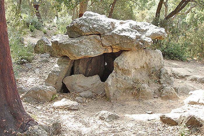
Cova del Alarb is in the Alberes Mountains to the south of Argeles-Sur-Mer. It is quite easily reached by leaving the town and going under the motorway towards the Chateau de Valmy.
The path up from here is clearly marked as is the position of the dolmen when it is reached. It is around 10 km to the east of Balma del Moro.
The views from the path up the hill and from the dolmen itself are superb, making it well worth a visit if in the Languedoc-Rousillon area.

The dolmen is in amongst the trees on the side of the mountain. These trees are cork oak and as you can see in the photos the bark has been removed from the lower half of the trunks.


Balma del Moro is at around 600 metres in the Alberes Mountains on the Col- del Pomers to the south of Laroque des Albere .This is in the Languedoc-Rousillon area. It can be reached by pathways , which are clearly marked , being in France, from either Laroque des Albere or Sorede. Markings on a board nearby put it at between 4000 and 2000 B.C.
The climb up is quite strenuous but the views and the dolmen are worth it. Both of the villages have some fine bars which we found very relaxing after the walk.


Looking down across the Butter Brook.

The most easterly of the houses in the settlement.

The roundhouse seen on the top of the hill with it’s two annexes running down.

The settlement with the Plym valley meandering away in the background.

The settlement viewed fron Ringmoor Down.

Willings walls settlement with Hen Tor in the background.

The settlement viewed from the top of Gutter Tor.

This is a large cairn usually missed even though it lies beside the road leading to the small parking area at thr foot of the Tor.

The kist at SX574655 showing the remaining end and two sides one of which has fallen in.

The cairn looking north , showing some of the remaining stones.

The prominent cover of the kist with the two remaining side stones in the foreground.


Brisworthy Circle with Legis Tor in the background.

The ring cairn with Sheeps Tor in the centre background.

The last few stones of the row and the cairn circle.

Looking north along the row from around half way.


The ring cairn with the stones of the cairn at the south end of the row visible in the background.

The much reinstated cairn to the west of the Down. According to Jeremy Butler many of the stones have been added in recent times.

The Cairn at SX560661, with three Tors in the background.


The reave that runs across Ringmoor Down from SX555655 to SX575673 looking towards the south east.


Part of the remains of the enclosure wall.

A roundhouse in the Tor enclosure.

One of the round houses in the enclosure to the south west of the Tor.


A photo of the kist taken on 28/5/2007 .As you can see from the previous photo the kist will soon be overgrown.

One of the better preserved huts of the settlement. This one still has it’s doorway intact.