Just to emphasise it is a really steep climb, a very windy narrow path i places a foot wide. And when it levels out coming to the cairn there is a near vertical drop on the left, so not advisable if the wind is high
wideford


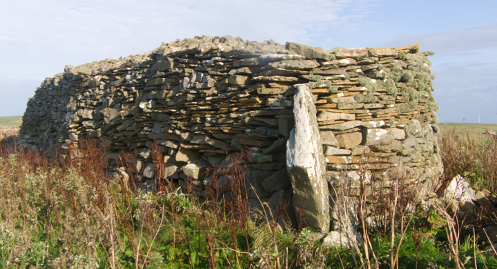
Going north to Dounby the North Bigging Road is a sharp turn on your right with the broch clearly marked on the map, but I approached from the other end after going on to Dounby and turning off there so (hopefully) I could see other sites along the way. After the Holodyke Hunting Lodge (no mere gateway but a grand mansion) the road turns back down to the main road. On the left is a converted wartime building and the broch is in the next field. After I did my work the farmer came to find out why my interest in his “knowe”, rather bemused. A very understanding chap and I would suggest speaking with him beforehand as we need more people like him and I enjoyed our brief chat. There are a few exposed parts of the nound but I’d say that from what I saw the “many stones of considerable size” have gone. It also looks to me as if the present SE edge was the border because the field over the dyke is so level, though the report says that the long pit there might be wall core. Near the top of the downhill side is a shallow bowl that could be a cell as a low ridge seems to cut it off, though from the side it does appear like part of a structure heading down to the base of the mound.
Midhouse/Mithouse NMRS record no. HY32SW 17 at HY30802000, is a large grassy mound SW of Mithouse, 10~12’ high and 132’ by ~100’ orientated NNE/SSW with many large stones on its slopes. In 1935 a small excavation found passageways and massive walls – it is thought to have been a broch as a shallow 54’ D depression on top is surrounded by a low irregular bank.

looking northwards across mound with structure C lower right
Image credit: wideford


structure C at lower southern side of mound looking from ‘northwards‘
Image credit: wideford


on top of mound looking southwards with ?structure B at left
Image credit: wideford
In February coming down the Evie Road the field containg this was open, so I took the opportunity to see the greater portion close up. Climbing to the top I noticed several metres of what could have outer face of broch tower wall. Couldn’t see if ever so slightly curved or straight but the stones at the edges could be the “stones, several of which, laid on edge, can be seen protruding through the turf” that the record mentions. Actually, going down the southern side, is a definite structure with three built sides visible to perhaps several inches deep by 18 across. I assume this has ‘appeared’ since the 2011 geofizz. Could be a small fish tank or the top of a toilet I guess.
Maes Howe and Tormiston Mill shut for the next fortnight

SHETLAND SITES IN OLD ORKNEY NEWSPAPER REPORTS
Bressay
July 18th 1865 “The Orcadian” George Petrie and Dr Hunt excavate 65’D 10~11’ high bowl barrow. Near the centre 5-6’ below the apex were fond a “peculiar” stone tool (similar to one found at Sefster on same trip), potsherds and ox bone fragments. Tumulus made of burnt stones, having a circle of stones just inside the perimeter with the remains of an encircling circular wall a few feet inside that. On the wall’s inner face, roughly 15’ inside the north perimeter, a large edgeset freestone block was found facing the centre. This was held up by a wall either side and had a large perforation near its upper end. Not far from the mound, but unconnected, were found two inscribed stones, each with a different kind of runes. These were taken to Lerwick..
Brindister Voe HU25NE 6
July 18th 1865 “The Orcadian” Broch of Brindister at edge of steep cliff and defended by double earthworks landward. George Petrie and Dr Hamiltton saw doorway and traced galleris in the circular wall but didn’t examine inerior as choked with debris from broch tower.
Broch of Burraness HU58SW 1
October 31st 1865 “The Orcadian” described. In 1854 one of the best preserved broughs in Shetland but a lot taken for cottage building in Burraness.
The Brough HU48NW 3
31st 1865 “The Orcadian” llttle left of Brough of West Sandwick’s wall.
Brough of North Garth ~HY547005
October 31st 1865 “The Orcadian” brough below house, at beach’s N end, almost entirely gone.
Brough of Stoal HU58NW 1
October 31st 1865 “The Orcadian” at least 3 ditches cut off brough at stole/chair of Awick, very high banks.
Brough of West Yell
October 31st 1865 “The Orcadian” name mentioned.
Burgi Geo HP50NW 2
October 31st 1865 “The Orcadian” description of approach to brough on Burgar Goes, a site mentioned by Hibbert.
Burra Voe HU57NW 2
October 31st 1865 “The Orcadian” little left as most of Brough of Burnavoe stones taken to build house at Burnavoe by owner Mr Henderson, entrance to underground passages now blocked by stone.
Charlotte Street, Lerwick
February 12th 1886 “Orkney Herald” stone cist with remains, probably previously disturbed, found near surface in clearing site for Mr Ogalvy’s houses at bottom of Charlotte Street.
Clickhimin HU44SE 2
July 18th 1865 “The Orcadian” Broch of Clickimin [sic] in worse state than Mousa but wall restoration more in keeping with design.. April 11th 1888 “Orkney Herald” Stones removed from causeway by local butcher for building material.
Fillicomb Point HP50NW 3
October 31st 1865 “The Orcadian” some ditches of brough in heads of Toft remain but part of broch fallen into the sea.
Foula
June 27th 1883 “Orkney Herald” report from “Shetland News”; man on Foulis [sic] finds fresh-looking but headless female body, lying on an o.g.s. of stunted heath, after digging 6’ through solid peat.
Giant’s Grave, North Yell
July 29th 1871 “The Orcadian” close to St Niniian’s Kirk site (Papil Bay) is a N/S aligned low mound called giant’s grave and never built upon, though slight attempts to excavate seem to show natural sandstone only.
Gossabrough HU58SW 1
October 31st 1865 “The Orcadian” chambers visible in Brough of Gossaburgh ruins, graves reported nearby.
Graveland HU49NE 3
October 31st 1865 “The Orcadian” remains of buildings at Brough of Bergaard on small peninsula.
Greenbank HP50SW ?53
July 29th 1871 “The Orcadian” two stone fragments with worn lettering found at Clinsara Reggs on the meik of Papal by Margaret Craigie of Millby Cottage servant, near the St Ninian’s Kirk site.
Head of Brough HU48SW 2
October 31st 1865 “The Orcadian” description of Brough of Brough.
Holm of Coppister HU47NE 1
October 31st 1865 “The Orcadian” Brough of Cuppister mentioned (name only).
Levenwick HU412NW 3
August 21st 1869 “The Orcadian” recorded by Dryden.Broch excavated down to the foundations within the last fortnight by Gilbert Goudie and described. Only finds part of a handmill and bone fragments.
Loch of Huxter HU56SE 1
June 17th 1879 “Orkney Herald” described in notice read to Society of Antiquaries of Scotland..
Mailand (Unst) HP60SW
June 10th 1876 “The Orcadian” D Edmonton’s men digging May 31st on area long dug for peats discover 4 cast metal items together mouth down in the peat, a large basin and 3 fire-pots different sizes.
Mousa HU42SE 1
July 18th 1865 “The Orcadian” description of Mousa-Borg, where restorations have been made to the walltop and the doorway but those to the latter has greatly changed the appearance.
Muckle Heog East HP61SW 12
September 27th 1864 “The Orcadian” burnt human bones from crouched people found in cist 18” below ground level in digging hole for flagstaff, 2 skulls sent by Mr Edmonton to Mr Roberts at Somerset House.
Papil Bay HP50SW 4
July 29th 1871 “The Orcadian” St Ninian’s Kirk site at the Kinwail ‘gard of Weeping’ close to mound called giant’s grave.
Sefster HU35SW 14
July 18th 1865 “The Orcadian” celts and stone knives found by minister Bryden several years ago in underground passage at Safsetter/Safester. Passage re-opened and many more tools found, including one similar to that already found in a Bressay mound. Potsherds and stone vessels also found.
St Ninian’s Church HU32SE 4 ?
August 26th 1885 “Orkney Herald” letter from the “Scotsman” describing situation of unenclosed disused St Ninian/Ringan’s graveyard: ~6 miles from Fitful Head on E side of tidal outlet on W side of mainland’s southern part. Soil is loose light sand to a great depth.
Trebister HU43NW 13?
March 28th 1883 “Orkney Herald” preparations on Saturday for a graveyard at a grass-covered mound belonging to Rev Mr Walker bring to light a ‘Pictish castle’, 40’ of a circular section 4’ high surviving from what is likely to have been a ~140’ outer wall of the building. Stone dyke encloses mound. Large quanities of dark red peaty ash in several places and a man’s jawbone found. Other discoveries were a few stone celts, several 12x8” ovoid polished stones (some with oval cavities) and four pottery varieties – 2 dark red soft earthenware sherds, a hard brick red sherd, and a vrery hard modern looking highly polished grayish sherd with light green spots.
Uyea, Shetland HU69NW 7
March 18th 1885 “Orkney Herald” article includes extra to P.S.A.S record of meeting, being mention of 3 steatite urns found in tumulus and 4 polished oval porphyrite knives found by Mr J Leisk, all exhibited.
MAINLAND SITES IN OLD ORKNEY NEWSPAPER REPORTS
Ackergill Links ND35NW 9
November 1st 1864 “The Orcadian” excavation of cists by Mr Laing April 24th 1866 “The Orcadian” Petrie says the mound is natural September 18th 1866 “The Orcadian” Laing gives reasons why Long Mound is not wholly natural
Birkle Hills ? ND35NW 5 ?
October 3rd 1865 “The Orcadian” from “John O’Groat’s Journal”
Birkle Hills ND35NW 5
October 3rd 1865 “The Orcadian” from “John O’Groat’s Journal”
April 24th 1866 “The Orcadian”
September 18th 1866 “The Orcadian”
October 18th 1893 “Orkney Herald”
Dingwall
December 3rd 1870 “The Orcadian” previous Tuesday 2 E/W aligned cists found 6’ apart in gravelly eminence at W end of Dingwall a few feet under clay subsoil. One disturbed previously, other had two decorated urns in fragments with human bones at eastern end
Ha’ of Bowermadden ND26SW 7
October 3rd 1865 “The Orcadian” from “John O’Groat’s Journal”
Keiss North/White ND36SE 3 Keiss White Gate Broch
October 18th 1893 “Orkney Herald”
Keiss Road ND36SW 1 Churchyard Mound / Churchyard Road Broch / Kirk Toft
September 18th 1866 “The Orcadian”
October 18th 1893 “Orkney Herald”
Keiss South ND36SE 2 Harbour Mound
October 18th 1893 “Orkney Herald”
Kettleburn ND35SW 11
November 8th 1864 “The Orcadian” from “John O’Groat’s Journal” cists have been found in adjacent field on Long Hills ridge October 3rd 1865 “The Orcadian” from “John O’Groat’s Journal” referred to as only properly explored broch in Caithness, dug by Henry Rhind
Kirkatahos
April 24th 1866 “The Orcadian” worked iron fragment found in chambered tomb in middle of Kirkatahos moor on hill/ridge
Long Hills
November 8th 1864 “The Orcadian” from “John O’Groat’s Journal” in next field to Kettleburn broch 4’ by 3’ cinerary cist found on Long Hills ridge. Similar cists have come from the ridge in the past and a bronze brooch found in one by landowner James Henderson of Bilbister sent to Society of Antiquaries museum
Thurso ND16NW 17
July 22nd 1896 Orkney Herald” discovery location and description
Yarrows
November 1st 1864 “The Orcadian” roughly 2 years before Ackergill Links ND35NW 9 dug J.G.T. Sinclair of Ulbster excavated Bronze Age cist in conical mound on a hill summit in Yarrows with skeleton similarly interred with shore material brought from some distance away. Found with bronze spearhead, 10” long porphyry lance-head, black clay-slate.battle axe with 7” blade, porphyry knife and arrowheads, broken black stone knife and a mallet head broken at the ends
Wester Broch ? ND35NW 4 ?
October 3rd 1865 “The Orcadian” from “John O’Groat’s Journal”
Wester Broch ND35NW 4 Keiss Wester Broch
October 3rd 1865 “The Orcadian” from “John O’Groat’s Journal”
April 24th 1866 “The Orcadian”
September 18th 1866 “The Orcadian”
October 18th 1893 “Orkney Herald” reporters did not have time to look at


Appears as Unyatank on the 1st 25” map, which sounds the more likely name. Even on 2nd 25” it is Unyatauk not Unyatuak. Only seen it from the road, but there appear to be two similar rises ‘behind’ this mound
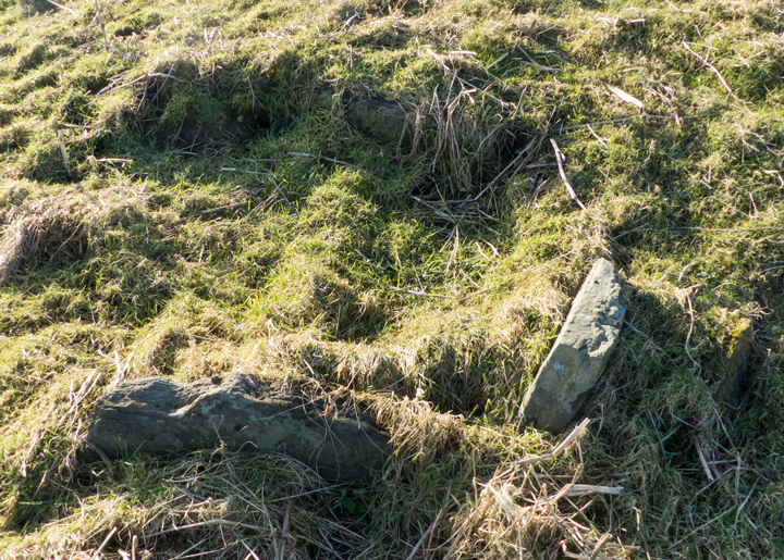
Just north of the Sandwick war memorial take the road going east through the Midstowe and Netherstove. Before reaching Netherstove take the diagonal track up to the minor road and turn right. The Rossel Howe wall is plain to see two fields east of the road. I didn’t realise you can walk straight up to it (the fence is practically gone) and so came around the edge ofa field. Looking at the rise atop the hill the cairn sits on I woner if it isn’t man-made. At the southern end is a pile of stones that could be the remains of the second cairn, badly robbed for stone. Rossel Howe cairn is a rectangle with well rounded corners, feeling almost oval to me. There is another pile of stones at the other end of the cairn, buth this is obviously leftovers and parts that have come off the wall. The stones are very different from the two slabs, which are mostly white. It doesn’t come out well in my photos that the erect slab sticks out from the cairn material at an angle of, say, 45 degrees. It is said the two slabs could have been parts of a cell. But there must have been a reason why they are where they are, and given the angle of the slab it strikes me that whoever built the wall was surely marking for posterity the place where the entrance had been (in which case could it even be in its original position ?). Standing at Rossel Howe there is a grand view almost the whole way around, and the mound is easily seen coming up to Skail. Indeed, because this day the hill was distinctly multi-coloured I was ablt to see it as I walked several miles towards Twatt and retracing my steps several more going to Stromness. If you wish to avoid the roads the set of tracks going by the site of the ‘Snusgar’ excavations takes you to the Netherstove farm road.


looking at the end of Rossel Howe over what might be the second cairns remains
Image credit: wideford


diagonal view of front, as I believe, of Rossel Howe with erect and prostrate slab
Image credit: wideford
LH side diagonal view of Rossel Howe – erect slab is not actually square to cairn
Image credit: wideford


standing stone with others not earthfast in same depression/whole
Image credit: wideford


view with northern edge of rim at LH side
Image credit: wideford

looking down on northern edge of depression
Image credit: wideford
On your left hand side going west to Kirbuster the Burn of Kirbuster which connects the Loch of Hundland to the Loch of Boardhouse is part of a long narrow field, look down the line of the fence and you can just make out the standing stone in the preceding field. Having seen it on visits to the Kirbuster Fsrm Museum it was good to finally visit the site. As CANMORE mentions, site HY22NE 10 is in a marshy area, don’t go through the damp bits (I tried) but around. The depression in which it sits varies from 2.5m to 3m across. The stone as it stands now is at an angle, the longer side 1.1m the shorter 0.5m and the top 0.6m long with a thickness of 0.25m. Yes there are several big stones along with it in the water-filled depression, but rather than the stone looking ‘modern’ the feeling you get is that it is part of a larger whole (it is another matter as to if the stone be original or planted later). Looking to see if the stone could have been part of a ‘standing stone fence’ all I could find was a few metres away two large stones face down in the ground, one larger than the other. When I turned back to the stone it is evident that at least part of the depression is rimmed, stones peeking out from the side. I do know of the traditional Orkney connection between standing stones and wells/springs, but none appear here on the map


Take the south coastal road, not taking the Ness Road, go as far as the Frustigarth Road and take that. The stone is in the second field after Cot on the Hill, don’t be tempted by the first field as it is rather boggy. I went to have a look at the wartime building on the other side and found what could have been an outlier. Didn’t measure it but say a metre square with another stone underneath

Cliiside view of broch settlement from Cauldrus looking northwards
Image credit: wideford

there was a cave at the bottom of the cliffs. A paraphrase “Almost opposite to the door of the main building a pit or shaft has been sunk down to the roof of the top of a large underground cave, dry at half-tide. The margin of the top of this has been finished at ground level with large thick edgeset stones to enclose a square with each side about four feet, narrowing to roughly a yard square some 10’ from the cave bottom. One of the stones had a notch cut on its upper edge, probably for holding a bucket rope. At sea level steps seem to have been cut in the sloping westerly side from the cave bottom upwards, and at the NE side other steps have been cut for access from the sea ”
Image credit: wideford