


mound looking south from Sandyhall junction


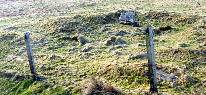
After Norseman Village take the Gorseness Road and at Grind turn onto the Hackland Road. On your left is a field with large wartime remains/ruins. In the next field a building perhaps of the same era marks Sandyhall barrow 3. There were others here but the only prominent one is near the farmroad junction. This mound of earth with a few stones is directly beside the Hackland Road and has several large scrapes.
There were originally five or six mounds in the field next to Sandyhall, NMRS record no. HY31NE 7, In 1966 three survived; 1/A at HY39861951 a squared off grassy mound about 15m across and rising to 1.8m max, B at HY39861945 a spread out mound roughly 10m D and 0.7m high (Sandyhill 1 0.15m in height in 1993), and C a significant rise some 12m D and 0.8m high at HY39891937 (Sandyhill 3 partly protected by a building and 0.3m high). “The Orcadian” of November 3rd 1863 describes a cist found in the centre of a Sandy Hall knowe by John Louttit. This cist was roughly 3½’ long, 20” wide and ~18” deep. Removing the rough flag coverstone revealed a burnt clay urn filled with burnt bone. This well-used urn had at some stage had to be clamped/stitched together and “broken long ago”. The cist was re-excavated in 1968, described then as an E/W aligned cist 0.91x~0.5x~ and ~0.4m deep, sitting on the natural.
Last year the known burnt mound at Meur was removed to another site, now there is a larger and even earlier mound being excavated in the usual race against time.
facebook.com/31395967167/photos/a.222229797167.114824.31395967167/10152415664612168/?type=1 and Thursday’s edition of Around Orkney (available on Soundcloud now)

looking inside the broch from hillside opposite


Broch Age wall remnant is likeliest spot for a kirk to have been built upon
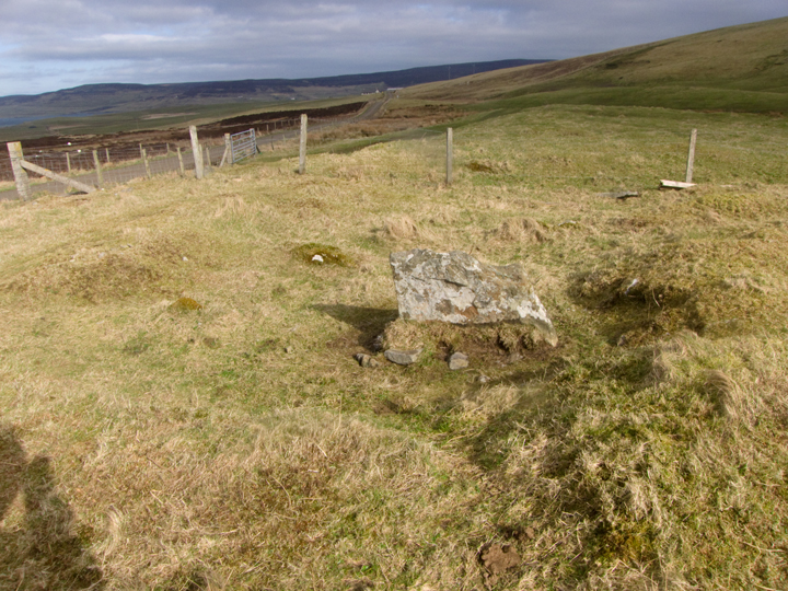
Take the bottom end of the Gorseness Road. North of the road is the Loch of Brockan, south of the road just before Grind is a steep-sided mound in the middle of a field. This is St Mary’s Kirk in Isbister, Rendall, NMRS record no. HY31NE 2. On reading a 1941 newspaper account that the tenants were forbidden from clearing the field or removing stones I was happy to see from the road stones here and there, but once in the field it is obvious that this virtue has been undermined as cattle have started to trash it. The protection was not afforded to non-ecclesiastical monuments in the vicinity, as the 1880 Name Book reports that the farmer had demolished adjoining ruins, at which time this site showed the remains of two concentric structural walls. A 1941 newspaper report spoke of half-buried well-squared stones, and definitely by 1967 the O.S. saw neither walls nor structure. The approx 1.4m high mound had been squared off by ploughing to leave almost vertical sides – no way you can call them that now. But you can certainly see where some building has been on top of the mound, for at the northern end a slightly raised section of much darker grass covers a few remnants of Broch Age wall. Perhaps it’s the kirk. What we have from St Mary’s itself belong to the burial ground. The 1880 tenant excavated human bones and likely gravestones, and the 1967 O.S. mentions that nearby at HY39961870 the farmer at Grind found a pile of human bones between parallel stone walls topped by a flagstone. Sensibly he put things back where they were and again the O.S. could find no trace.

‘back’ of broch mound seen from track coming down from side of Vishall Hill


view of mound from shoreline facing it shows broch goes right down almost to shore, as evidenced by good wall exposure

well-exposed basal wall just above shoreline, you probably need the right tide to see it


southern view from the shore showing low turf-covered slab path/wall heading for front of broch mound – perhaps proof of Hedges’ conjecture that boats were hauled here

from the broch mound to the bank behind the later enclosure
Even taking photos along the way it took me under 50 minutes to reach the broch mound from the Evie Road, but you can get by car much of the way. Just north of Woodwick is the Ardwick Road, go up this to the top where there are several farms clustered together. Behind Arwick there is a half-snapped-off sign for the beach (wonderful how markers self-destruct in Orkney) and you continue down past Lower Bisgarth to where there is a parting of the ways. From Vishall Hill you can make out the broch because of the brightness of the later drywall enclosure stuck behind it. On the left a farmtrack goes to the sands by the northern side of the lochan (with its almost vestigial ayre) while on the right you take what is almost a farm road down to the shore and turn to your right for the Ness of Woodwick. I went at low tide but it seemed to me that you could walk the outside of the field with care if the tide were too high. Even though on the map the Craig of Ritten juts out it felt to me more as if the broch mound was tucked into the land. Though the 20’ internal wall arc mentioned in the report is indeed hidden now there is another exposed at the bottom of the tower, not much above the shore so easily masked if you visit on an incoming tide. It struck me that the tower must survive under the mound almost complete. All over the mound you can find the odd stone. However the nature of a broch is that these being isolated I could not tell if these were simply part of the massively wide broch tower wall or parts of other structures. Clambering up to the top I could see several lumps and bumps inside the medaeval/’modern’ enclosure and just beyond it. What with the surviving height of the broch tower and the topography I would deem it likely that the rest of the broch settlement survives under the turf. I wish I could find my Photoshopped version of the ‘original’ Google Earth image I found, as it clearly showed the tower outworks as a surviving plan despite the ground cover. On the composite image from two satellites you can still make out a figure-of-eight with one side a dark line of inner and outer broch tower arcs and connection (?entrance side). Also away from the main broch you can see the bumps I saw. Most obvious is a beetle shaped oval directly adjoining, almost entirely contained by one side of the ‘modern’ enclosure. Which makes the site extend inland like the other Evie brochs.
Ness of Woodwick broch, NMRS record no. HY42SW 9, aka the Craig of Ritten/Rittin. The ‘crag’ is an impressive mound with dimensions estimated as 50-60 feet across with an inner diameter about half that – in 1946 at the seaward side to the NE about 20’ of outer wall (thought to be the outer wall-face) could be observed. No midden was seen. Twenty years later most of this outer wall was overgrown like the rest of the mound. Hedges notes that the rocky outcrops and sand below would be a good place to haul up a boat.
In Evie village opposite the ‘new’ school is the Aikerness road with a sign for the Broch of Gurness (originally the Knowe of Aikerness). Going down the road where the farm on your right ends Redland South is in the second and third fields down – when I went three-and-a-half years ago, taking photos from the roadside bank, I didn’t realise that the bulk of the cairn lies in the lower field because I went purely by the Pastmap marker. Certainly the ‘upper’ section is the most visibly man-made because of the large excavation pit around what had been known as the Redland standing stone, and looking across to Vishall Hill two long shapes look much more like burial mounds (they are above where Keek once stood). This is because the cairn sits on a the flat top of a natural mound rather like later cists were placed in false crests and rises. Indeed it feels as if the ‘upper’ section is a seperate entity as with the Head of Work. The lower field’s remnant (entered by another gate) is rather unimpressive, especially as with a warming climate the protruding stones detailed in the record are hidden by grass. I came across then haphazardly, and it struck me that rather than ragged stumps these are original tops – I don’t see why the standing stone alone would have survived levelling.
Redland South cairn, NMRS record no. HY32SE 17, was at least 27m long by 12m wide. Aligned ESE/WSW it sat on the edge of a shallow NW/SE plateau ~83m x ~15m, a natural dip on the NW side marked by an old track. A long stalled chamber is marked by eight protruding stumps. The compartments were most likely some 1.65m, though there was a longer compartment or two shorter ones between slabs 6 and 7 and the end compartment was also somewhat longer. The Redland Standing Stone and its partner formed a stall 4.1m from one end of the chamber [either the other stalls also once stood to a man’s height and they are much reduced or there was a considerable variation in height, though what comes to my mind is Weyland Smithy]. It is thought possible that the cairn continued beyond the NE cairn material. Also there is a 1.3m long 0.4m high orthostat SE of the chamber not following its axis.


roadside view parallel to dividing fence of ‘upper’ section

cairn seen from top of hillock opposite looking uphill


‘upper’ section seen from downhill side of dividing fence

‘upper’ section showing stones near dividing fence


view across ‘upper’ section from dividing fence


2 largest of Seven Knowes seen on skyline coming from northwards

one of chief mounds on skyline (object just visible is top of a trackside quarry, in case you’re wondering)


largest of the Seven Knowes seen from track


looking down on mound with ‘scrape’ from a few yards uphill