I have now determined that the chambered mound (HY31SW 20 at HY30391280) is the same as the Kokna-cumming “burnt mound” (RCAMS 1946 Inventory 899, HY31SW 28).
wideford


stone and fragments looking from NW with mounds on Ness of Seatter in the distance
Image credit: wideford

against setting fragment fragmented or fresher fragments
Image credit: wideford
The Deepdale standing stones (having NW/SE axes), RCAHMS NMRS no. HY21SE 25 at HY272117, used to be a pair – A at HY27171171 and B at HY27181166. Standing at A facing the Unstan Cairn eighty-two degrees clockwise and 44.5m away is/was B, the other side of the south-east fence and further up the hill. The latter was the longer stone at 7’6” compared to 6’, though its top was a foot less vertically as at some time in recent centuries a then taller stone had been snapped and the unshiftable remainder left at an angle. It tapered from a 5’3” maximum to a point, whereas A is 4’6” thick (4½” thick) and sub-rectangular. A has a roughly 1x0.2 m edgeset-stone setting showing about 0.3m high, with a roughly metre long stone fragment alongside (there used to be another fragment – one assumes therefore that this s.s. was also slighted). In the 1960’s heavy ploughing disturbed stone B and the bulk was removed for safety. The remaining stump, projecting 8-10”, was excavated later (at this time other fragments remained) but not enough matter found for the C14 methods back then to work. It measured 4’5” by 6” and sat clay packed in a 6’6” by 4’ by 3’ deep cut. Most likely the excavation process finished the work of removing this stone
Coming from Unstan and the Brig o’Waithe, not taking the short road over to Stromness but taking the long sweep round it is easy to see this stone on the brow of the hill above the near corner of the quarry-turned-dump. Easiest to go over the gate in the roadside field before this quarry and then over the gate into the containing field. Because the rain was persisting down and the fields full of corn I opted instead to go around the quarry and through a barb-wire fence. But the thistles meant my trews were dampened anyway! At the base of the extant stone a few broken stones are from the socket I would imagine (in the quarry roadside I espied a large stone that may be part of that destroyed other). Trevor Garnham has the broad face the same direction to Unstan as the Setter Stone is to Braeside, which would have been at 45 degrees to the reported NW/SE alignment of the stone [it is at the same longtitude]. The latter appears to indicate the Dyke of Sean or maybe the Wasbister disc barrow.
The Hunterian museum is re-assembling his(mostly Northern Isles) donation and adding this to their catalogue as they go huntsearch.gla.ac.uk
At present this is text-only but images will be added over the coming months


Wanting a photo of a cliff on Shap at the junction before Work farm I took the LH turn towards the waterworks. The beach you see between here and the start of the Carness headland is the result of man’s works. Earl George of Caithness in 1614 made first landing at Carness in the campaign against our Earl Patrick. Until modern times all cattle headed for the Scottish mainland were ferried from Carness past Shapinsay, but the ferry point is unknown AFAIK.
At the turn-off for Water Board property the wartime road continues up to the headland. You need to go through two fieldgates, the first of which is chained against vehicles, then along the north coastline keeping to the coast edge. It wasn’t truly damp – there are numerous small drainage deltas, however they all have a smattering of what amount to stepping stones.
As you come to The Castle geo (not quite a rock stack yet) you see Long Cairn across the moss to your right. The long horned cairn [Yarrows type] is 47m long by 12-17m wide, on which is a 15-17m oval mound (Davidson and Henshall report that the ruined chamber was dug before 1928, in which case when RCAMS in 1946 give the mound’s height as 11’9” this must have been prior to that as later authorities give a total height of 2-2.1m and the RCAMS Inventory side elevation shows nothing above this chamber) an Orkney-Cromarty cairn. It is generally accepted with a site such as this that the chambered cairn was completed long before its incorporation by the horned cairn. This site, the Helliar Holm cairn (above the lighthouse to the north of here), and that at Haco’s Ness (on Shapinsay away to the east as you look there), are all intervisible – from which some intended guardianship of Shapinsay Sound has been inferred.
Along the higher ground on this northern side of the headland as well as the various purple orchids I was delighted to see Grass of Parnassus. What most struck me, though, was a darker form of eyebright mingling with the usual form – it appeared that they both grew on the same plant, the same coloured throat but violet instead of white elsewhere on the flower. I expected The Castle, a geological feature, to be difficult to recognise. Plain as a pikestaff really, a future stack with a short modern cairn (possibly hollow) of brown stones on top. I could have climbed down up the narrow neck... coming back might have been trickier. In the neck’s ‘valley’ there is an angled wall, of the same material and equally modern looking, at the eastern side. Beside this what resembles a solid cartwheel is apparently covering a well or something. The other side of the wall a large slump of water-worn rocks goes to the rocky beach far below (only after seein a picture I took have I seen steps on the southern side of the wall that go down to this [or I would have myself !]). By the cifftop the other end of the narrow beach is a bank of soil where the earth has been scraped up fairly recently.
After passing The Castle I crossed over mushy ground to the long cairn, soft-going but I did avoid damper patches. On this side of the mound I could see middling-size stones, presumably from the small late structures referred to by Davidson & Henshall others perhaps connected with the reported rectangular hollow (west of the chambered mound) they also believe prehistoric but not original. In my initial approach from The Castle circling clockwise the south horn of the western hornworks was very visible as a long broad grassy strip with a rounded top, looking like a pseudopod or starfish arm.
Coming to the western end the inside of the eastern hornworks my first impression was a sharper, less obtuse angle than shown on plan. I wonder if they have eroded back where these ‘end’ as this appeared higher than the reported height to me (however the O.S. earlier did report this end of the mound as of greater height).
Up on the mound not much more than a step from the back of the hornworks I found a feature [my A] surely not previously noted, as D&H state that turf covers all except the high mound. It takes the form of an oval, 4.8m wide by 3.8m front to back, on which lie many slabs. These are in a slight depression but as I looked back from its eastern edge a very low bank was visible. Perhaps it is a chamber of the later long cairn, but if instead this is from a second original mound it would help explain why the later cairn has appeared too long hitherto (the Roseness cairn also has an apparent satellite, even lower than this).
Next along I saw a slab projecting a little, distinct from the glimpsed ‘wall-faces’, then further on again the base of the main mound. The latter is about 12m across. Continuing to the back there is a 0.68 long angle topped slab projecting 0.3m , and a little distance on at the high point a hollow [my B1] filled with stones and slabs that is is 3.1m wide. At 1.4m from the western edge by the back end of the hollow (2.1m front to back in D&H) is 0.6m of an orthostat 1.1m wide was plain to see – I think this is in D&H as 1.5 by 0.65, wary of getting too closeI may have missed a bit. It is unfortunate that though the RCAMS Inventory shows this chamber on side elevation it is not indicated on the plan view, because half-a-metre to the right of B1 is another slab- & stone-filled circular hollow [my B2]. This is 1.7m across and fractionally lower on the hill (there are orthostats in B1 whose level is given as 0.65m below that of the rear slab). A second stall or possibly another chamber I would imagine (I suppose it might be that the turf between the two is simply the result of archaeological methodology). Then, just behind this, the other side of an imaginary line from B1’s largest orthostat is a depression [my B3] 2.3m wide and 2.2-2.6m from front to back. Despite there being not much stonework poking through B3 I would hazard that this represents a robbed stall/chamber (hence its apparently more downslope position) resulting from digging prior to the 1920’s period in which B1 is likely to have been excavated.
At the eastern end of the long cairn the S horn survives over twice the height of its NE counterpart making the latter less eviden on first viewing. At the moment the forecourt is very clearly defined by a singular display of a bed of reeds. Full distances and dimensions, as far as I could measure on my own, are givn under miscellaneous.
Though the ground about the site is mostly damp and springy this is boggiest on the southern side where it slopes down to the cliffs. I tried to get back this way but it was way ‘boggy’. When I kept to the drier portions this brought me to a ‘mound’ which is presumably the western end of the ridge, and less than a metre in front of this a bank or dyke, both apparently composed of earth with a few stones. The latter is rather bulky and would seem to emphasise control over the approach to the cairns, as along most of the Head of Work what some call rough pasture most would think of as approaching shallow bog (Roseness is similar though heathery). This must be the route Moth and Jane took through Work farm, once site of a broch and perhaps a souterrain.
After heading down across to the cliffs I went along the clifftop under the watchful eyes of two seals, but came to stop where the drystane fieldwall reaches the cliff. At this spot there’s a girt big pile of slabs 3-5’ long and maybe 4-6” thick, like a fallen stack of dominoes. Followed the wall back up to a gate, but with the field having kie in it I left well alone. This would seem to be the normal route to the headland. Further up another gate had a sloped top ‘standing stone’ over five feet tall as one of the gateposts. Then I was back at the military road again.
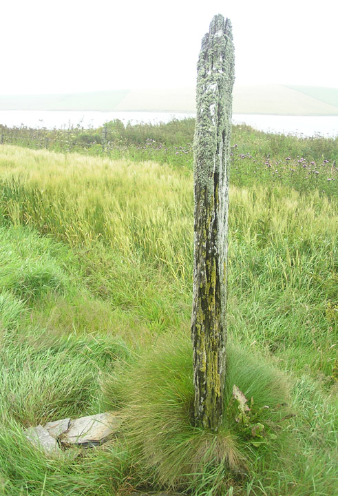
The field is named Stenso from stens-a ‘standing stone burn’. Today the open gate gave entry. I found a N/S aligned stone at the top of the hill. It projects less than it is thick i.e. 6” or less. If this is the stone it has become further reduced this last couple of months, if not then it is previously unrecorded. I had my photos but a tractor man ordered me off before I could take measure of the thing. He said that I wasn’t allowed and the land was private [an English derived conceit]. After the bullying I forgot to check from the road for the proper s.s. if this wasn’t it and doubt I’ll dare again.

N/S stone on top of mound viewed from west side, tape extended to 1m mark
Image credit: wideford

N/S stone on top of mound viewed from above
Image credit: wideford
My field measurements (some approximate) for clearest features of ENE/WSW site on E/W ridge, going from front=western to back=eastern ends (’’ = metric conversion) :-
From back end of Hornworks 1 to edge of feature A = 0.2m. A is 4.8m wide by 3.8m f-b (flat uneven stones on slight mound. ? chamber of long cairn). At 2m from A is a a small projecting slab, then 6.1m from this to edge of main mound B. This is about 12m wide . At 6.5m from mound edge is a 0.68x0.3 m projecting slab with angled top. Then another 1.4m to edge of feature B1 3.1m wide at summit (stone- & slab-filled hollow. ?chamber). From this edge 1.4m a to 1.1m long orthostat by back edge (slab showing 0.6m of top) is 1.4m. From eastern edge of B1 to mound base 6m, then 3.3m to back end of Hornworks 2. Only 0.5m to right of B1 is similar hollow B2 but 1.7m diameter (? another chamber – or is seperating strip a product of excavation ??). Behnd this is depression C3 measuring 2.3 by 2.2-2.6m (? robbed chamber).
Other sources :-
Site [’47x12 by 3.6m’ at E end] O.S. in 1964 height 2m E to 0.9m W
Hornworks 1 [NMRS ‘14.6m’ across horns internally at front] {Davidson and Henshall NW horns project 3m and are 0.5m high}
B [’ >12 by 3.58m high’] O.S. 2m {15 wide by 16.8 f-b and 1.4m high at NW end, 2.1m to GS}
Hornworks 2 [externally ‘24.1m’ across] {SE horns 24.7m across, project 8m and height NE 0.3 S 0.7m}
In “Harray – Orkney’s Inland Parish” the map for the Grimeston district shows a field called Green Brae field directly south of a site called Syabank site. These are described as a “Pictish mound” and a “hole near an ancient grave or cists” respectively.
Orkneyjar will be posting updates on this season’s dig that starts Monday :-
orkneyjar.com/archaeology/brodgar2007/index.html
After a promising start the expected Mesolithic windfall was a no show, the present hypothesis being that work on the barrow removed most of this previous material.
My visit to the excavation left me distinctly underwhelmed. First impression is that a mushroom-cap shaped rise has been revealed that consisted of a layer of small to medium sized flat stones sitting on top of soil (as distinct from embedded in an earth matrix). In the eastern quadrant they have dug through this. Just in front of what seems to be the very decomposed inclined top of a rocky outcrop (reminding me of the geophys lines at the other end of Long Howe) is a 4-6’ line of stones that looks to be at least one course of non-drystone walling. Apart from a couple more stones after a small gap it is isolated, doesn’t seem to be going anyplace or connecting up with anything else presently visible [so no mortuary enclosure then ;-) ]. Perhaps something later trashed this and the postulated Mesolithic material?
Walking around to the NW side of the dig (facing the road to Twinness) I saw an irregular shallow narrow trench that I take to be where they looked for a continuation of the previously found stakeholes or else the originals.

composition of surviving banks on plantation side (now cleared of worst excesses of vegetation) revealed, one occupying most of image part of ?mound other further back at extreme right ?embankment or enclosing arm of enclosure
Image credit: wideford
Work started again last week [volunteers needed for on-site sieving this week and next – see News]. Went round yesterday and there was a JCB on top of the mound. A strip has been exposed behind where they [re-]excavated the cist last year and I could see levels being taken and limited digging apparently underway. Having heard Radio Orkney this morning the reason for hesitancy is obvious, finding microliths being even more labour intensive than normal tool finding [alas volunteering is forbidden me]. My own betting for a settlement is still the relict beach at the bottom of the road.
P.S. there is no Mine Howe season this year, but it is open for visitors and there is a small shop / interpretation centre on site.
Today Radio Orkney reports that a great number of Mesolithic tools have come to light, though presently this is thought to represent a refurbishment workshop rather than a factory per se. They urgently require volunteers to sieve the whole of the spoil heap for microliths missed by the main thrust of the excavation
no pic of rock art yet but
orkneyjar.com/archaeology/harrayearthhouse2.htm
Another souterrain has come to light in Harray (see Dale) in ploughing a field for barley . Historic Scotland has given a 3 week grant for its excavation, no visitors allowed. With it a hole in the same field reminiscent of that found by the South Keigar earthhouse in Deerness, Orkney.
orkneyjar.com/archaeology/harrayearthhouse.htm
2nd week on Corrigall earthhouse :-
orkneyjar.com/archaeology/harrayearthhouse2.htm


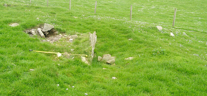
Suggested chamber remains seen from SW, ‘back slab’ at left is/was 1.6m long 0.6m high
Image credit: wideford

Looking W across suggested chamber remains, orthostats reported 20-30cm thick
Image credit: wideford


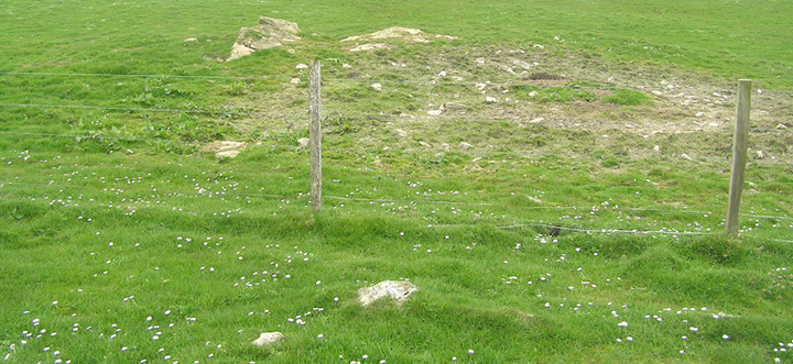
View looking S From what I take to be the suggested revetment along lower half of mound
Image credit: wideford


N side of mound or mound extension noted on previous visit
Image credit: wideford
Looking from beside main body of mound W across top of other
Image credit: wideford
If you go “around the houses” there will be a way in through gates, but this being the end of a decent dry period I took a shorter but naturally difficult route into the field containing the bulk of the cairn. By the field boundary is the mound with large exposed stones that I photographed on a previous visit believing it to be part of the cairn. Now I have my bearings this is not recorded as connected. But there is a strong suggestion, in my mind, that all is part of a bigger site that arcs around this hillslope. Perhaps it is all on some glacial feature, glacial action that is presumably the cause of the very large boulders being embedded in the banks of what I assume to be a former burn further upslope. On this part of the hill several features appear to run into one another, and a few of these also appear to have been trialled for archaeology..


raised circular bits between mound and farmhouse
Image credit: wideford