wideford


NOT A KNOWN FEATURE
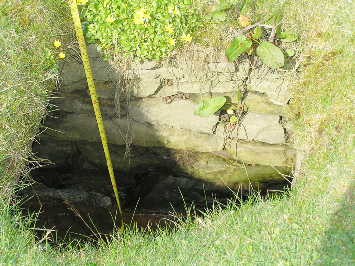
My first notice of this feature came when walking the Crantit footpath from the town end. Reaching the corner where it turns back down to the main road and looking across I spotted a lintelled entrance over the other side of the ‘drain’ there, at the corner of the field with what looked to be the remains of a low mound over it (HY4415709002). The feature being above water level, and the piece of ground about the base reasonably firm (neither of which is usually the case), I jumped across the burn. It is composed of drystane walls and flags covered the bottom. At some time an attempt has been made to consolidate the entrance with cement. Though by crouching I could get inside I bottled out of waddling through the entire tunnel in case of sticking, especially as I could see one place near to where the roof had opened up. At that time I did not think to see much at ground level. Of course there was also Petrie’s tomb “close to the shore of Scapa” [not the same as another he dug south of Lingro whilst engaged on the broch but perhaps up on the same side of the bay].
I felt that it stood an outside chance of being the ‘true’ Crantit earthhouse as this entire area, probably once an oyce [tidal inlet], used to be part of the Crantit Estate. The early O.S. maps show nothing for this field, not even a well it might have connected too even though there there were a couple closer to Nether Scapa itself. There are ‘drains’ and straightened waterways throughout the estate, but these are very strictly gridded and do not follow the same alignment. Stepping Stones were marked at a Burn of Crantit bend to the SSW, which is the only other existant (pre)historic feature in the vicinity if it hasn’t been dredged out.
This year after looking in the field the O.S. placed their suggested souterrain (all I found was a stone socket, just possibly a short cist, underneath the fence along the field’s northern border) I went for a better look at my ‘find’ in the next field. This lies near to the western edge where the burn is but runs at an angle to the field edge. Its far end is under a slight rise near what seems to be the first of a short series of old dunes. Between this and the entrance is fairly level, which is what you would expect had this been merely a drain. The passage is covered with thick slabs of ‘unnecessary’ width as shown in several places where these covering stones have somehow fallen in. There appeared to be no more to this feature, though before the entrance is reached there does appear to be a kink – two roofing slabs do not look to point directly to the entrance, however it would need twa folk to check on this together. Even if it weren’t for the notable disparity in alignment despite the slight resemblance of the walling to parts of the Agricultural Improvement ‘drains’ said parts only cover the two or so metres necessary to go from field to field, the rest being uncovered.
I had a few doubts, but the week after I happened to look through my newspaper clippings and found a photo of a feature very like my passage. This was someone in 1995 asking if anyone could recognise where the tomb in said photo had been !! Unfortunately there were stone fieldwalls in the photo and the hills didn’t look to match the view I remembered. Alas nobody answered the querent. Still I hesitated over publishing this site in case (against the odds) I were sadly mistaken as to its age. Then last week I saw three couples with dogs crossing the field, which was very weird. They were nowhere near the passage but in case someone is planning on developing the field I am risking possible humiliation in order that it should be on record before it might suffer damage.
In the images the tape measure is extended to 1m mark.
Castle Bloody first appears as the site of a Pict’s House or Fort. This mound (NMRS record no. HY51NW 4 at HY53591643) on a moorland summit in the NE of Shapinsay had been partly explored by a local prior to 1923, when a newspaper describes it as a gallery grave i.e. a souterrain like Grain and Rennibister on Mainland. Later it is called a chambered cairn. Finally, for the moment at least, it appears as a variant souterrain. This appears to mean a monument type where a mound covers one or more passages, each ending in one or more chambers built on the o.g.s. Unfortunately in or after 1972 a capstone blocked the single certain chamber here.
This 13m diameter grass-covered stony cairn has a modern marker on top, despite which from being nearly 1.7m high in 1928 the height has apparently eroded to 1.2m. The removal of several massive capstones, east of centre at the south side, revealed a N/S corbelled irregular chamber roughly 1.5x 0.9 m in plan. This is entered from the south-east by a 4m long curving lintelled passage, roughly 60cm wide and a minimum four drystane courses high, through a 90cm square chamber entrance. Below the level of this passage another left from the cell’s north end. Though blocked it could be seen to turn north-east after about a metre, where what looks to be a hollow packed loosely with debris could be a second cell – it is believed there could be yet more cells in the mound leading off similarly. The certain chamber is itself now choked with debris and has become blocked by a displaced roofing slab.
If one pictures a corbelled chamber of rectangular plan with side cells leading off surely the image conjured up is that of Maes Howe ?? Right time of year for miniatures.

seen from main road
Image credit: wideford
There are two sites at the Knowe of Midgarth, a long hillock adjacent to a circular mound [vaguely reminiscent of the ‘Viking’ mound and broch at the Howe of Hoxa]. Raymond Lamb says these two comprise a single settlement. Davidson and Henshall believe the former to be a “variant souterrain” like Castle Bloody (presumably the ‘gallery grave’ that used to be in Stromness parish, this term once e.g. used to describe Rennibister and Grain earthhouses) whilst P.O.A.S. VI in speaking of a grassy mound containing “sailor’s graves” is surely referring to the latter [ so ? like the “West Broch of Burgar”]. But all we know about the cairn (NMRS record no. HY32SE 1 at HY39872360) is that it is 100 yards SE of the hillock and has suffered a lot of plough damage but survives roughly four feet high and fifty across.
We are better served by the records for the probable [multi-period?] settlement, HY32SE 6 at HY39812361. A five metre long passageway at the west end leads to two sub-rectangular corbelled cells, the size only given as small.. The first is two steps down from the passage, and though probably entry had been gained by antiquarians through its roof this had been repaired. Slightly beyond the chamber a short south-east passage leads to a larger cell through a narrow access, now blocked. Since before 1967 entry from the SE has blocked up and the two cells are filling up with debris.
On the north side is the entry point for another passage that curves for at least ten metres before it is blocked. The shore nearby has a likely hearth consisting of four edgeset slabs that has produced charcoal. A trial excavation near the eastern top of the hillock has revealed yet another possible passage with maybe more cells, though this walling (way above the level of the north passage) consists of very overgrown stonework jumbled about. On this side of the mound facing the beach fragmentary masonry could represent a related drystane wall and there is kitchen midden along the eastern shoreline
To the north of the knowe the irregular Midland earth tumulus with small stones is thought to cover a prehistoric structure, though only one large-ish stone protrudes. HY32SE 7 at HY39732368 was slighly over half the size of the Midgarth tumulus (25~30m) but farming has removed a good deal


Looking for another way to the Broch of Burgar I went past farm and mansion houses. Quickly I realised that the field here contained the cairn, not the broch. Even from uphill the cairn impresses with the brightness of the off-centre chamber, especially the prominent inner pair of slabs. It was still rather damp and I went back and forth several times before entering. Despite the slope I found the field totally waterlogged, and suspect it usually is. The whole was densely pockmarked by hoofprints holding yet more water. There was no escaping the darn stuff, though on my way back up I found the high edges of the burn banks to be fairly dry (the burn makes some lovely little waterfalls and I could see long regular stones exposed in the banks that must surely have supplied the better of the cairn material). I think one should always treat published cairn plans as more in the nature of diagrams.
Perhaps careful observation would have made the chamber clear to me, but there is a heck of a lot more going on than you would know without a visit, the surviving portion is very busy, rather a jumble. I might have been able to scramble a way to the broch field but its a good drop if I made a slip. Definitely need good gripping boots, a dry day, with measurements and ‘plan’.
NMRS record no. HY32NW 15 is a chambered cairn one nautical mile from Howana Gruna. But once it was thought to be a broch and even referred to as the West Broch of Burgar and shown on the first O.S. maps as broughs, these supposedly paired brochs compared to those on Burray. According to P.O.A.S. VII, in 1928, some years before a lot of the stone had been acquired for farm buildings. Within the mound there had been (or believed to have been) the usual “sailor’s graves” {might the Burgar hoard have actually come from here ? It would have been a good ploy for a suspicious farmer to mislead treasure seekers by saying it came from the broch). On the aforesaid maps a thick-walled square structure is shown a little beyond the mound on the coastal side of the fieldwall. The Castle legend is displaced offshore on more modern maps Presumably it is only coincidence that the long cairn on the Head of Work also has a castle at the cliff-edge nearby, as what can be seen there nowadays looks essentially natural.
A 1935 report in the 1946 RCAMS Inventory describes a 52’ grassy mound with a flat hollow 37’ wide bounded by a ridge 2-5’ high having a small section of possible inner wall face exposed at the north. Two E/W slabs near the centre projecting 2’8” from present ground surface were compared to the divisional slabs at the Unstan Tomb. Two slabs of 6’ and 4’ a yard to their east, edgeset, were comparable to Unstan’s side entry if they were in situ, possibly including a further stone in the putative passage.
The presently exposed chamber according to Davidson and Henshall consists of compartments 1.8 and 2m long. Their Orkney volume adds another piece at the northern end blocking this chamber where an axial passage might have been once , the previously mentioned (angled) wall face which they think most likely to be exposed cairn material only. The two presumed displaced slabs (aligned N/S) they assume to have simply been part of the chamber [though these are distincty out of proportion with other elements of the chamber, surely]. According to Davidson and Henshall the cairn has a definite edge to give it a size of 17.5m (i.e. over a metre greater than previously reported – oblate?), and stands to 1.9m max. at the SE. The cairn’s composition is reported as substantial flat stones of a very friable nature.
As described by them this NE/SW chamber consists front to back of :-
Slab pair (outer) are 0.65m apart 20cm thick, projecting 0.2 & 0.5m, with the first the only slab not 0.6m wide. Slab pair (inner) 0.6m higher up are 0.55m apart (1935 1’4” from a different place ?) 5 cm thick, projecting 0.8m but apparently once taller – that at the SE presently has its top level with the surviving mound top. The barely projecting back slab is 10cm thick and 0.2m above the outer pair.


I came down the track to the beach that goes past Evie graveyard (St.Nicholas Chapel site) expecting not to reach this site but turn right for Gurness, the latter fee free for St.Andrew’s Day. However it looked a doddle to get to so I went. Not quite so easy as I thought, despite a reasonably low tide. As I came nearer from the shore I could see at the far end the very tippety-top was a wedge shape that must be the highest surviving point of the broch tower – inner or outer face leastways. It is nice to see the external bank you come to first this way is an obvious one rather than some slight rise visible to the eye of faith. I can see why the remains are unsurveyable so far as discerning structures goes, for between the bank and the main mound the remains I saw consisted of several othostats at varying angles and various scattered slabs apparently face down.
Unfortunately the field fence is taut and I didn’t feel safe in essaying a climb over so I contented myself with hauling myself carefully up onto the mound edge this side of it, from whence the yards to the highest portion of the mound’s coastal edge weren’t so bad. Just on the other side of the fence there are enough slabs sticking proud of the surface to form a rectangular structure, possibly even two. Definitely surveyable I’d say.
This side of the fence there are a few smallish round holes in the dark earthy matter but not enough to bring worries of rabbit infestation. Probably midden rather than burnt material, though I could see no sign of individual components. Unfortunately the coastal side of the fence gives out here, not even the barest of ledges. On the other side of the mound there is as far as I could tell no continuation of the outer bank, though the broch’s inner bank is clearer here and the exposed tower wall is nice (not a patch on the Broch of Burgar of course).
NMRS record no. HY32NE 11 is a 4m high broch with asymmetric settlement (“unsurveyable”), there being many edgeset slabs between the main mound and an external bank to the south that strikes up from the coast. It has been stated that this site has not been excavated, but in 1916 (when the surface area of this knowe was given as [on the oder of] fifty yards by ten) locals remembered a man called Johnny Fea going inside the tumulus so deep as to hear otters at work. A seal bone borer came from exposed foundations at the north side. These are traceable for roughly twenty feet and indicate an outer wall of at least twelve feet thickness (there are traces of a one foot wide intra-mural gallery atop the mound). Other finds were two beads and many likely potlids. On the other side of the Burn of Woo is a probable burnt mound, a metre high, called Robie’s Knowe.


Coming along the shore from the Knowe of Stenso is not easy – even at low tide it as a matter of skirting rocks, clambering up and down geos, crossing over and through burns. Even following the fence line I found some of the boggy bits. Unlike Stenso the fence beside is slack enough to climb over [though no dout they’ll remedy that the morrow], however on coming to the high point without entering the field and then peering over into the slightly depressed top all I saw was grass (in 1928 the P.O.A.S. says neither this nor Stenso had been excavated, but he likely meant professionally as a local had been down inside the latter). To me the site didn’t feel the right orientation for a broch, though as I mistakenly thought I’d a pic from the main road I have no image to check whether it truly is edge on to the coast. Certainly I would have expected to see some signs of a bank outwith the mound. That said, just over the fence at the highest point I did see a few projecting slabs I felt to be an even slighter version of the structure I had seen earlier at the Knowe of Stenso in the exact same relative position.
NMRS record no. HY32NW 10 is thought to be a site like that which covered Gurness broch and settlement. The grass-covered stony mound is over a hundred feet across and sixteen high, with several edge-set stones indicating structures below the turf. Gru(d)gar is two fields away and over the road. Ryo is the original appelation and is likely to be either Orcadian ‘roo’ meaning heap of stones or a variant of Grugar (a spindle whorl found on the farm has the name Grudiar/Grudair attached).


Point of Hisber and Broch of Burgar seen from field to north containing chambered cairn
Image credit: wideford
The hazelnut was found in a layer beneath the Bronze Age burial mound at Longhowe during excavations earlier this year. The charred shell has been dated to 6820-6660 BC, and its discovery pushes back the known settlement of Orkney by 3,000 years. Mesolithic settlement has long been known from stone tools, but the nut has provided the first definite date.
Now downloadable at ads.ahds.ac.uk/catalogue/library/des/index.cfm as a .pdf for each year from 1947-2001. However these are facsimiles, so you really need to know which year you want as these won’t be truly searchable
Sigurd’s article on the Ahrensburgian flints from Stronsay orkneyjar.com/archaeology/stronsayflints.htm great colour photo of these two primitive arrowheads
Prior to Farrer’s 1854 excavation this was an apparently untouched tumulus, about five feet high with very steep sides, but subsequent (unrecorded) digs have removed all recognisable traces of his work. He and Petrie found cists at the south and north sides 2-3 feet down. The former, about 6 feet from the centre, measured 2’6"x2’x2’1” internally, but had side slabs 5’10” long and an irregular capstone 4’ by 2’6”. This cist had been sealed with clay, but the 1½” thick flags were much deteriorated and at odd angles. Within this a large steatite urn sat upon the meeting of four slabs and contained burnt bones and ashes. On the other side of the barrow they found a slightly smaller cist, at 2’9½” by 1’7”, that held a small clay-and-gravel urn. The urn held only a few small pieces of stone, being mostly filled with what is described as soil. It fell apart in Kirkwal. However there were many bones laid on a flag in the NW corner beneath fine soil. Petrie reports the later finding of a broken pestle (??macehead, perhaps THM 1985.34 ??) and a stone vessel with two rows of ringmarks like those seen about the steatite urn.
In his volume on round houses [sic] Mackie has a possible broch in the locality, but nothing further is known by him for his HY41 6 at HY421120.
Sigurd’s report on The Cairns of the Bu
