A follow up on Rhiannon story of Jesus in Priddy. I heard a story many years ago that the local people of Priddy would use the phrase, ” As sure as the Lord walked in Priddy”. This would be used in the same way as someone today might use the phrase ” Is the pope Catholic?“.
V
vulcan


The Bulwarks on Minchinhampton common could be iron age or possibly later. The earthworkings are about 1 mile in length stretching between SO857004 and SO863013 and possibly cut into bedrock. There may also have been a dry stone wall some 4 foot in height retaining the spoil of the waste stone. There have also been modern day quarrying of stone from the SO857004 end.
Image credit: Vulcan
Uley Bury Hill fort 1-Aug-2004
We entered Uley Bury Hill fort from approx ST782981. There is a bridle path here which is basically a narrow gully that leads up to the top of the hill. Due to the fact that there appears to be a gateway into the fort at or near the top of this gulley, then I assume the gully to have been made as a passageway to the fort rather than natural, which would probably make it unique. At the bottom of the gully there is medium sized dressed stones that shore up the earth banks but whether they are original work, I don’t know, but they do remind me of the small visible wall found at South Cadbury Camp.
As one travels up the gulley there are small irregular stones that appear as stone walling and these may be original work?
As one reaches the top of this passageway/gully, you are greeted by a huge steep natural defence to the camp proper. You should note that there is a path between two artificial mounds that was probably once the gateway into the camp.
The camp itself is about 30 acres in size and although it’s fenced off you can still walk around the perimeter and take in the fabulous views.
To the Northwest one can see Cam long down and the isolated Peaked down, which has Arthurian connections. On the Southside of Cam long down and on the top there appears to be earth defences.

Having walked up the long ‘passage’ up the hill, and you thought the climb was over, you are then greeted with this sight!!
Image credit: Mike


View of the very steep natural defence of the South west side. Not shown on the picture is a small ditch defence at the bottom of this natural embankment.
Image credit: mike
Aerial Photo of three of the henges. The unfinished henge is not seen.
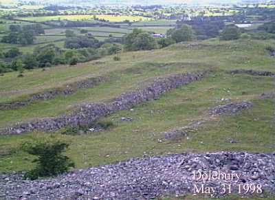
Although I’ve never seen it myself, there is suppose to be an huge cross cut into the bedrock on or near this hillfort. This would be similar to the way bedrock was cut out on nearby Dolebury Warren.
Experts have just declared Aveline’s Hole to be “Britains oldest cemetery”. a study of over 800 bone fragments found about 100 years ago have revealed that they are about 10,400 years old. Included amongst the bones is one that show signs of osteoarthritis, the oldest case on record.


This folly castle was built in the mid 1700’s on the hill that was originally an iron age camp. St Blaisus (sp?) an hermit lived on the hill and thats where today we get the term blaizer for jacketwear. There is some connection to Jane Austen and the castle whether it was a direct connection or featured in her storyline, I’m not sure.

Blaise Castle built in the 1770’s as a folly. The castle is sited on top of the Iron Age Camp in the grounds of the estate.


The tree here in the ditch may have a good reason to be there – to stop mountain bikers? The exhaust pipe has no reason to be there.

A double ditch defence. At this point the centre bank peters out.


This may well be the southern most henge of Priddy Circles?


The ‘tump’, as it’s colloquially named, is a later feature of the 22 acre Maes Knoll fort and is part the great earthwork, Wansdyke.

If you go to the fort this way, as I did, then you will soon realise the mistake you made!!

Boundry of the fort
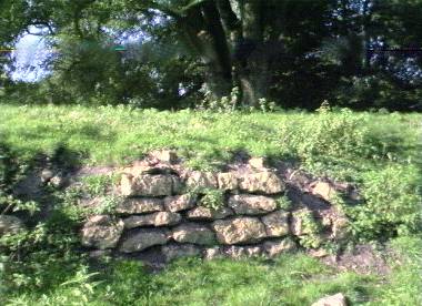
These loose stones have been cut out of the bedrock.
Using the GPS co-ordinates from TMA I took myself off to Felton Common in search of this Longbarrow. The GPS guided me to roughly the position as suggested, and after the best part of what seemed like an half mile walk through scrubland, I couldn’t see anything about so a little searching led me too what I can only think is, or was, a derelict Longbarrow. IF this is the longbarrow, and I’ve every reason to believe it is, then it’s probably in one of the worse conditions I have seen. The stones that are in the field would have made for a large Longbarrow in it’s day. Felton Common is quite large and seems to be favourite for dog walkers. it’s not a place where you should go to far out of your way to see though.
I will go back oneday because the common hold a secret that very few people probably know, until now, in that it’s a very good place to watch planes landing because one is directly under the flight paths of very low incoming planes. Now what can be better to waste some time on than that!!!

Is this what remains of Felton longbarrow? Is it the longbarrow?

Westbury White Horse and the tell tell signs of the ramparts of an Iron Age camp just to the right of the horse- in this case Bratton camp.
Look out for ‘Arthurs Well’ as you go up through the lane to the fort – Like me and my first trip to the fort, most people don’t know its there.

Glastonbury Tor just visible on the horizon (approx 15 miles). Glastonbury Tor, Brent Knoll would have been used as beacon signalling against Irish invaders coming up the Bristol Channel.

Looking down onto the well defined ramparts and ditches.
Part of the ancient wall defences for South Cadbury

Disturbed ground where ‘Arthurs hall’ was discovered.

Grotto – A Victorian folly.

The layout of the fort.

Cross sectional view – artist impression of how it would have looked.

Rocky outcrop on top the fort.
You can see where they got the stone for building the walls.
Cadbury Hill fort – AKA CadCong
-------------------------------------
The fort on Cadbury Hill was built about two and a half thousand years ago. It went out of use during the Roman occupation of Britain, but was subsequently resettled during the Dark Ages.
Cadbury Hill was probably occupied by members of the Dobunni tribe. Gradually they developed their hill settlement into a fortified camp by constructing a multiple ditch and rampart system of earthwork defences topped by a stone wall rampart.
Cadbury Congressbury is one of five like-named Iron Age forts in the Southwest area. The name is Anglo Saxon and means ‘Cadda’s Camp‘
Recent excavations not only uncovered its Iron Age beginnings but also important facts about its subsequent history. Despite the Celts fierce will to resist, their hillforts were a poor defence against the highly trained Roman legions. Thus, Cadbury Hill, like most others was abandoned during the Roman occupation (AD 43-410). Nevertheless, under a stable Roman administration the Congressbury region experienced a flourishing growth in population, settlements and land use. Recent fieldwork in Congressbury parish uncovered evidence of a large number of lowland settlements dating from this period, including a group of kilns which manufacture large amounts of a distinctive grey pottery. Their products can be found widely distributed in the region.
To the North of the hill in Henly woods a pagan Roman temple was built. After it fell into ruin in the fifth century, local people who had presumably been converted to Christianity, were buried at the site over earlier pagan graves
Unlike most other hillforts, Cadbury Congresbury, also referred to as CadCong, gained a new lease of life in the Dark Age with large scale reoccupation between AD 410-700. Evidence of several rectangular as well as circular buildings has been found. judging by the number of people that nay have been living here, cadbury was a Dark Age settlement of some importance.
An intriging find from this period was the foundations of a very large circular hut. It seems to have had a ritual purpose of some kind, but it is now known if this was Christian or pagan.
Dark Age settlement of the site was confirmed by the discovery of amphorae (large ceramic wine jars) still being imported from the Mediterranean lands despite the breakdown of the Roman empire.
The nearby settlement of Congressbury was founded in the Saxon era by St Congar, a Celtic holy man from Cornwall.
According to legend St Congar plunged his staff into the ground where upon it took root. To this day there is an ancient yew tree in the churchyard known as ‘St Congar’s walking stick’. Such a miracle persuaded Ine, the Saxon king of wessex to grant land used for a monastery.
Cadbury Hill is a Scheduled Ancient Monument.
The story on the plaque of the Portbury Stone is as follows
===================================
On the 27th of september 1987 this ancient standing stone was recovered from the field below the church after having been buried in an old dew-pond since the early 1950’s.
It is thought that the stone was originally erected in the late Neolitic period, ie around 2000 BC. It’s precise purpose is not fully understood.
The stone is of a type found commonly in this area and would most likely have been quarried near to Conygar Hill.
The rock itself is of a type called Dolomite Conglomerate
and would originally be reddish-brown arising from the iron deposits in the soil.
Re-erection of the stone was carried out by members of the PORTBURY ASSOCIATION so that it might be preserved for posterity. Thanks are due to many people in the village who assisted in the rescue
project


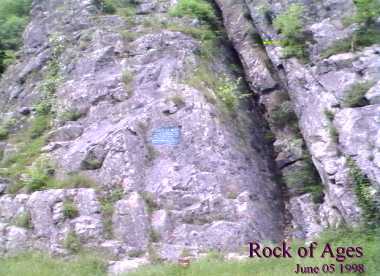
Nearby Aveline’s Hole is the cleft in the rocks where the Rev Toplady was inspired to write the hymn ‘Rock of Ages’ while sheltering from a thunder storm.

1-50 of 69 postsNext page