“The twin dales of Fryup (Fri-hop = Frigas valley) meet to th south of the elevated oval-shaped barrier which seperates them. The southerly tip of that rising piece of moorland is called Fairy Cross Plain, a name which dates to more than two centuries, and accordingly to local folklore, this used to be the haunt of fairies”
Folktales from the North York Moors
Peter N. Walker
Pub. Hale
1990
fitzcoraldo
“You enter the circle between the two largest or portal stones, which are both bigger than you. Directly opposite, on the other side of the circle, is a stone called ‘recumbent’ or ‘axial’ by archaeologists; by which they mean it lies sidewards rather than upwards. Ancient markings have been carved on it’s upper surface. It’s been suggested that they represent axes, and this proves that these circles were not a place of worship, but the focal points of a Cult of the Axe which existed in Western Europe in Neolithic times. Or the stones may have enclosed a market-place, and the axial stone was the counter on which goods were traded.
I have to say, though, that shopping seems an unlikely motive to me. Proponents of this undeniable imaginative theory make comparisons with shopping malls, which might be seen as the new temples. Shoppers are worshippers, McDonalds is the sacrament, Nike provide the vestments; but the theory is of course rampant bollocks, and seems so particularly in a part of the world where there are no malls, but you can still buy a bicycle in a pub. The stone is quite clearly, an altar stone, and something would have been placed or celebrated- or sacrificed-on it.”
Pete McCarthy
McCarthy’s Bar
Pub. Septre Lir
2000
Revisited.
A little more meat to add to the bones.
The settlement marked on the OS map is a large stone banked circle with a raised bank and ditch. It would have been the foundation for a very large ‘hut’*. It is stone walled with a definite entrance marked by large stones.
Nearby are other smaller earthworks that could be the remains of hut circles. And the site is defended by large double ditches to the south.
The cairn circle is the prize site
It is 12m in diameter and contains one large standing stone.
One thing I have never noticed about the Rigg before is that the peaks of both Freebrough hill (to the north) and Roseberry Topping ( to the west) are visible poking up over the surrounding moors. The site is overlooked by the areas main mother and father hills.
I’m sure this wasn’t lost on our ancestors.
*19th September 2004
According to Harding & Ostoja-Zagorski’s 1994 report, this is a Ring Cairn
Approach this site from the A171 to Castleton Road.
A track leads down to the enclosure.
The structure is roughly rectangular 26m x 40m and faces west overlooking Commondale Beck and Moor.
It is a banked enclosure with a shallow ditch.
Within the enclosure on the North West end is a circular depression approx 4m across.
20m to the north is a row of stones ? ancient field boundary with another row running off at right angles. Two large stones mark the corners.
This one eluded me today.
It’s marked on the OS Explorer.
I just couldn’t get to it.
I first tried down the lane from Mayburgh..dead end
Then from Yanwath..dead end
Then into the Skirsgill depot site from the M6/A66 roundabout...no joy
I thrashed around a farmers field and found nothing but a small low lying glacial boulder at the foot of the embankment of the A66.
There is a farm there and you can see the lane, but were it starts and how to access it beat the crap out of me today.
next time .......
I stopped off at this fella.
Very difficult to assess. If I hadn’t been told it was there I would never have guessed in was a long cairn.
The whole thing seems more like a long Dyke. I can see where the cairn side comes in because someone had cut into the side of the beast and the thing is definitely constructed of rocks.
The Easterly end is truncated by a ditch and bank, this could be a drainage ditch but it seems unlikely.
All in all a very unsatisfying site.
One thing though.
It is yet another site on the eastern margins of the lakes running from Grey Yauds in the north to south of Shap following what I call the Eden/Lowther Corridor of sites (at least 30 of ‘em).
I’m sure the rivers are significant in possibly what were axe trade routes and junctions.
This is a fantastic site although I would not advise anyone to approach it by the route we took.
Myself and my two dodmen apprentices took the road to Burnbanks at the head of Hawswater and parked up.
We then walked along the well made path until we reached Mile Craggs and the took the uphill route following the beck (no footpath).
My apprentices had a hard time of it but remained uncomplaining as they sank into bogs and were totally lost in a forest of bracken. I was trying to show them how to follow the sheep paths but failed miserably as even sheep are not daft enough to take this route up the fell.
We eventually made it to the top and were rewarded with fabulous views across Haweswater to Hare Shaw in the east and High Rise and Long Stile in the south.
The site itself is nestled in a lovely sheltered high vale.
You are first aware of the two stones on the horizon, as you walk up to them they seem to get smaller. One stone is upright the other is leaning. They look out over the southern flank.
As you move into the site you come across a small pond (about 30M long, very shallow) that is bizzarly flanked by a lowline of stones ( ?an ancient wall structure), slightly up the rise to the North east is a lovely hut circle about 10M across.
The combination of these three features coupled with the views and absolute isolation of this site make it a wonderful place to visit.
As we sat and admired the views we watched a storm move towards us, helpless to escape it we got soaked, when the storm moved on it left a beautiful rainbow across the fell.
Out of interest I’m sure this site used to be called the Giants Grave or graves but cannot find a reference to back me up.
I also wonder what happened to the other two stones of Four Stones Hill.
Any info?
My lad collected a mean set of sheeps bones on the way down! ” look dad , some of ‘em still have the skin on!”
His mum was well impressed when he took them home to show her.
If you visit this site, I would advise the safer less strenuous route from Drybarrows. Or walk along the lakeside to the Forces and follow the footpath past the waterfall.
“There is another camp of the Eston type (Eston Nab) at an altitude of 1075 feet on the brink of a vertical cliff at Boltby scar on the Hambletons. Here a semi-circular rampart with an outer fosse enclosed an area as wide as the Eston Camp but not more than 170 yards long. Within it are two round barrows and a peculiar oblong mound of unknown purpose. I noticed a few flint flakes on the cliff-edge.
The similarity of this camp to that at Eston Nab points to it being the work of the urn people whose remains occurred abundantly on the Hambletons.”
Early man in North East Yorkshire
Frank Elgee
Pub. J. Bellows
1930

Roseberry Topping Circa Early 1800’s
Pre collapse
Image credit: Print from Graves's History of Cleveland pub. 1808
“When Denmark’s raven soared high,
Triumphant through Northumbrian sky,
Till, hovering near, her fatal croak
Bade Reged’s Britons dread the yoke;
and the broad shadow of her wing
Blackened each cateract and spring,
Where Tees in tumult leaves his source,
Thundering o’er Caldron and High Force;
Beneath the shadow the Northmen came,
Fixed on each vale a runic name,
Reared high their altar’s rugged stone,
And gave their Gods the land they won.
Then Balder, one beak garth was thine,
And one sweet brooklet’s silver line;
And Woden’s croft did little gain
From the stern father of the slain.”
Nice eh?
that was from Walter Scott’s “Rokeby”
“The custom of giving names to wells and fountains is of remote antiquity, being common alike to earliest idolaters, to Jews and to Christians. In papal times, if a well had an awful situation, as at Rosebury; if it’s waters were clear, and medicinal, as at Hilda’s-well, it was the custom to dedicate it to some saint by name. To such an extent did this species of idolatry prevail, that it was forbidden in the canons of king Edgar A.D. 960, also in the canons of St. Anselm A.D. 1102. Notwithstanding, it prevailed without intermission till the Reformation, when many innocent customs and harmless superstitions were wholly extirpated because they savoured of popery.”
The History and Antiquities of Cleveland
J. W. Ord
1846
Republished by Patrick & Shotton
1972
Frank Elgee in his book ” Early Man in North East Yorkshire” describes his excavations of Eston nab.
Flints were discovered on the higher platform, “Good implements were scarce; chips, flakes and pieces numerous.” Further in the camp he discovered several cremations, flint scrapers, a leaf shaped arrow-heads, many quartzite hammer stones, a stone chopper, stone rubbers or polishers and numerous fragments of food vessels. he discovered a cup marked rock in the fosse and evidence of stone walling.
One disturbing feature he discovered was “minute pieces of calcined human bone suggested either cremations had been carried out on the discovered hearths or that a cannibal feast had be held”
The camp is dated to the bronze age by the food vessels.
“Stone Rows
These are rare. I discovered one in a small valley, Haredale, on the north Cleveland moors half-way between Commondale and Freeborough Hill. Here on a huge natural mound known as Old Castle Hill which projects from the western side of the valley at an elevation of 800 feet, are five small upright stones in a line about 150 yards long. The row, which is not absolutely straight, runs west-north-west by east-south-east, the most westerly stone standing about fifety feet from the others which are closer together. On the north slope there are some pits which may be hut sites.
On the end of the mound on which stands the stone alignment known as Old Castle Hill there are a few dry pits, possibly the abodes of the prehistoric priests or magicians whp performed their magical rites at the stones for the benefit of the neighbouring settlements, of which it may have been the sacred site.”
Early Man in North-Yorkshire
Frank Elgee
Pub. John Bellows
1930
“Wade’s Stones near Lythe and Goldsborough are mentioned by Camden as being 7 feet high. They may have been tampered with for one near Lythe is now about 6 feet high; two near Goldborough about 100 feet apart are 3-4 feet high. Barrows in which food vessels have been found adjoin these stones, which derive their name from that fabulous giant, Wade, who so tradition says, was buried near them. Curiously enough, at the base of the Lythe stone, Mr Hornsby discovered an unburnt Anglian burial, probably that of a warrrior, for there were also remains of an iron spearhead.”
Early Man in North-East Yorkshire.
Frank Elgee
Pub. John Bellows
1930
Shap Granite is very distinctive and easily identified by the large pink feldspar crystals contained within it’s matrix.
Shap granite is a very popular building stone and can be found used in buildings all over the UK.
This site has been an important cross roads since the beaker folk took residence on near-by Danby Rigg.
Close to this site are Old Ralph Cross, Young Ralph Cross and White Cross. These crosses make the confluence of major moorland pannier ways and also link the ancient sites of Danby Rigg, Castleton Rigg, Westerdale Moor (mesolithic) and Blakey Rigg.
Flat Howe is a minor round barrow but the nearby boundary stone is lovely.
It stands beside the road and is visible for some distance. The stone does not have the usual appearance of the local stones (see Blakey Howe) it is marked as a boundary stone with the Initials of the estate but from it’s appearence alone predates any of the Cleveland landed gentry.
Located just beside the Lion Inn on the Castleton to Hutton -le-Hole road.
Blakey Howe is easily mistaken for one of the many mine workings that cover High Blakey Moor.
If you check it out you will find a dug-out round barrow topped with a boundary stone.
The usual boundary stones for this area are about .5m tall, rectangular and fairly uniform. This fella is 1.5m tall and doesn’t look like any of the other stones.
The carved letters on the side proclaim the boundary of whoever owned the moor (and probably still does) but the stone implies a greater antiquity.
Whilst your there call in at the Lion Inn, great beer & decent grub.
There are excellent views across Rosedale to the Victorian Ironstone workings and the calcining kilns.

A Bronze-smith’s stash
A hoard that was discovered on Roseberry Topping and is now in exile in Sheffield museum
More info & pics of circle
The Browns discover ‘em and Greame C reports ‘em
Anoither newly discovered site, those Browns are turning stuff up everywhere!
This is a page from Greame C’s smashing site with pics and directions.


A lovely natural cast of a cup (which was replaced of course!)


Harkerside circle on a foggy day,not much to see. I guess you have to use your imagination...or go there!

Showing the rubble built bank

more pea soup, more bank & ditch

Pea-souper at Grinton. The bank and ditch

A brilliant second hand book shop with a huge antiquarian catalogue and very helpful staff.

One of the pleasures of ‘peel and reveal’ is the negative imprint you get in the grass roots


For sale
2 abandoned millstones
401 metres above sea level
Buyer must collect.

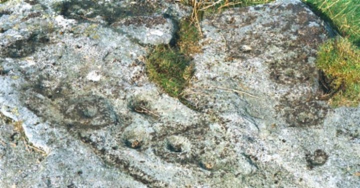
Over 30 cups on this fella, you’ll have to trust me on this!