Hidden amongst the verdant growth of West Penwith, the Carfury menhir takes some finding even on a sunny day.
King Arthur’s Bed is on private land and access is subject to certain restrictions, which from the end of August 2005 can viewed on countrysideaccess.gov.uk or in person at Trewortha Farm.”
Please make sure you adhere to these restrictions when in force.
A bit of a swine to find......
Take the road from Heamoor up Bone Valley then go straight ahead at the crossroads (signposted Carfury). The road descends into the valley winding past an abandoned quarry on the right. Just as you reach the bootom of the valley a path/track goes off on the left. There is room to park a car here.
Walk down the track ( I would guess it is muddy after rain) and when you reach the bottom there is a wall goes off on the right. If you are agile enough you can scramble carefully up the tumbled boulders here and get into the upper field. Walk out into the clearing and look up to your left. You should be able to see the stone standing proud above the vegitation.
From here you can continue up through the field. If you have decided to stay on the track then continue up to a gate. Go through the gate and then wind your way through the gorse, bracken, brambles and rhododendrons arcing around to the right but always climbing. At some point the stone will come into sight...but it is not easy to find this way.
The stone itself is a stunner..it stands about 10 ft tall, built into the ancient wall. From it Mulfra Quoit can be seen as can the sea to the south. I did not find the other stones that are supposed to lay in the area, due to lack of time....and a rumbling belly.
I have just written this up in preparation for a tour I have got to give to 40 americans to the site... thought it might be of some use to somebody:
Castle Dore supposedly means earth castle.
It is an Iron Age Fort consisting of an inner circle and outer circle. Both have an entrance in the eastern side, away from the prevailing winds. It is thought to have been built originally about 200BC.
Views from the fort are extensive, surrounded on both sides by valleys that would have been flooded in Iron Age times. The Fowey Valley to the east, and St Austell Bay and Tywardreath to the west. It is only in the last 300 or so years that the valley to the west has dried up and become farmland. This is a result of mining activities on the higher ground of central Cornwall.
The ridge that the hillfort is built on has always been an important trade route from coast to coast. At the time the site was inhabited the climate of Britain was cooling down. People had moved off the high moors to settle closer to the sea. They had started trading with other countries, Ireland and the Brittany area of France being just two examples. The people of these “kingdoms” would rather travel overland than risk the seas around Lands End, something that would continue well into the middle ages. The trade route, and the traders, needed protecting. By sticking to higher ground they had a good view of the surrounding countryside that most probably would have been heavily forested at the time. All across Cornwall hillforts sprang up, apart from the high desolate moors. Many still remain, others have been ploughed back into the landscape, only appearing on the occasional aerial photo.
It is thought that a small village existed outside the eastern gate of the hillfort in its early days. There is also evidence from aerial photos that a circular site of some sort stood a short distance to the south west of the hillfort. This could have been a henge, a Bronze Age ritual site, consisting of an earth bank and ditch. Was this where the Tristan Stone originated?
After the fort had been in use for 100 years or so it is thought that the defences were strengthened. This could have been as a result of the advent of the sling into Iron Age weaponery or it may have been because of the threat of a Roman Invasion. Whatever the reason, the walls were built up, probably topped off with wooden fencing, and a covered gateway erected over the entrance.
Experts believe the site was abandoned shortly after the Romans invasion of Britain. No evidence of a great battle has ever been found at Castle Dore and it is not thought that the Romans ever “invaded” Cornwall. The general thinking is that they traded along the coast and very rarely travelled in land, in fact there are only thought to be a few Roman sites in Cornwall, and they are only basic camps, possibly set up to shelter the odd legion.
The Romans called Cornwall the “Cassiterites”, a name deriving from the fact that there was tin here. This was the main reason for them coming to the county to trade.
So what happened after the Romans?
Experts differ… An excavation carried out in the mid 20th century found evidence of postholes inside the central circle. It was decided these were supports for a large hall or palace, a separate kitchen and another slightly smaller hall. Other buildings were also thought to have been included in this grouping including a chapel and stables. At the time it was said that these holes dated to the 5th or 6th century and tied in nicely with the story of King Mark. He is said to have lived in the Fowey/Lostwithiel area and through his association with the story of Tristan and Isult the argument for Castle Dore being the centre of his “Kingdom” was strong.
Sadly, for those romantics amongst us, we cannot stop there. Research done in the mid 1980’s failed to find any evidence that the site was occupied after the Iron Age. That is not to say King Mark did not exist. He could have easily lived at Lantyan, a nearby manor mentioned in the Domesday Book, and possibly the Lancien of the Tristan story. Chances are that wherever he lived it was a wooden structure, now long gone and we will never know exactly where it was.
In my view the name also holds clues to the fact King Mark never settled here. Castle Dore is said to be translated from middle Cornish and means “earth castle”. Middle Cornish dates from the 13th to 16th century, whereas many of the Iron Age hillforts in the area are prefixed with the word Bury or Berry, a word more associated with the Saxons or Britains. Did Castle Dore not get a British name because it was not occupied at the time?
In fact the Castle lay abandoned and forgotten until the English Civil War of the mid 1600’s. In 1644, with Fowey surrounded, the Parliamentarians commanded by the Earl of Essex, used the site as a camp. Eventually in August, King Charles I and his men surrounded the area, by which time Essex and Lord Robartes of Lanhydrock had slipped away and sailed to Plymouth in a fishing boat. The Parliamentarians, under Major General Philip Skipton, surrendered and the army consisting of 6000 men were disarmed and sent on their way. Unfortunately for them, many paid for the poor treatment they had inflicted on the local people during their occupation. It seems only 1000 survived.
Nowadays the site is supposedly under the protection of the national conservation body for ancient monuments – English Heritage. I am a bit concerned about the erosion being caused by the cattle that are put onto the site, but at least they keep the vegetation down.
I would possibly have walked straight past this stone, just taking it for another lump of granite. Ocifant had other ideas... and after a bit of examining we decided that it quite possibly was a fallen menhir.
Looking into the field there is what looks like three or four more stones lying in a row going south... towards the Leaze stone circle. A good Bodmin Moor wind, barbed wire... and Ocifants fear of long horned tatty cattle meant we did not explore further.
If the row does run towards the circle it is the first of its kind on Bodmin Moor, although many of the Dartmoor rows end in a circle or a cairn. There might even be a cairn at the northern end (a mound beside the fallen stone is about the right size and is made up of rocks).
Another visit on a sunny day is needed I think.

Looking south, possible stone row runs through field, above wall to the right. It might meet up with stone circle at southern end.


To access Castle Dore you will have to park in a layby on the Fowey side of the hillfort and walk back along the road. This is not for the faint hearted... beware of traffic.
On entering the gate the Castle Dore tablet stands nearby giving the usual outdated text...mainly about King Mark and all things Arthurian. It has been thought since the 1930’s that the fort was occuipied on and off since the Iron Age and that the large oblong building that wassupposed to have stood inside the centre of the fort was King Marks hall dating from the 6th Century.
Recent work suggests otherwise...that the fort was only occupied in the Iron Age/Romano British era and that King Marks Hall was actually at Castle a few miles north of Dore.
In 1977 aerial photos showed a round feature to the sw of the hillfort. It has been suggested that this was a henge and that the Tristan Stone was originally from the henge.
The hillfort itself gives spectaculer views out over Cornwall but sadly is becoming a bit of a mess. Cattle are roaming free up and over the embankments and along the ditch and bushes are being allowed to grow on the banks.
Oh....and I can see my house if I look east on a clear day...

To the south of the barrow there is marked on the OS map a circle of stones?...It is not marked as a stone circle and to my untrained eye, there is no sign of a circle. However, there are many stones lying around....could they be the reamins of something?
A30 in the background.
Set slightly higher up the hill from the stone rows, this is the biggest upright on the downs. The higher upright (of the group of three) can be seen on the ridge to the SE.
The reason why it is hard to find the settings on the downs is partly because of the gorse bushes. Although they do not cover the area they do have a habit of hiding things when looking from one point to another.


The stone row is split into two sections. Both lie on the northern side of the downs and are not easy to find. None of the stones are more than about a foot high. The western row has I think 7 or 8 stones then there is a bog gap to the eastern row which has about the same number. At the far eastern end of the eastern row is a stone about three foot long but now lying in the grass. A grass covered mound beside it is possibly a buried stone..there ia definatly something hard beneath the grass.
This low outcrop lies just off the B3212, about 2 miles outside Princetown. It is supposed to have a logan Stone amongst its piles but I found nothing that would rock. It is also an easy way to access the stone row below Hart Tor.

Cuckoo Rock settlement with Burrator Reservoir in the distance.
This huge rock sits on the southern slope of Combshead Tor and is a popular place for walkers to the area. It is I would guess 15 ft high on the shortest side.
Just to the north of it is a wonderful walled settlement featuring about a dozen hut circles in reasonable condition and beyond them it is a short walk to Down Tor stone row.
The rock is easily reached up the Deancombe from Burrator Reservoir.

A local tells me that the sun rises in line with this row at Midsummer...It is not facing due NE but taking in to account the dip in the hills to the east he may be right. The row dips in the centre as it crosses the hillside rising to the cairn (Stone Circle) at the western end. I did not get to look at the cairn as it was full of French people standing bolt upright pretending to be stones...


The northern row from the bottom (Eastern row in background)


I actually aproached this circle from the north, having followed the stone row from where it crosses the Erme River. A REAL adventure!
The “easy” way would be to come up the track from the hamlet of Torr near Cornwood, and then head out over the open moor, this is still not easy or a short walk.
Is it worth it? My photos may not do the circle justice...it was a very overcast day with the mist dropping down one minute and the next lifting. The whole Erme valley is full of antiquities...I think I past four stone rows and missed about four others on a eight mile walk, not including all the cairns and settlements, pounds, cists, and the odd standing stone...
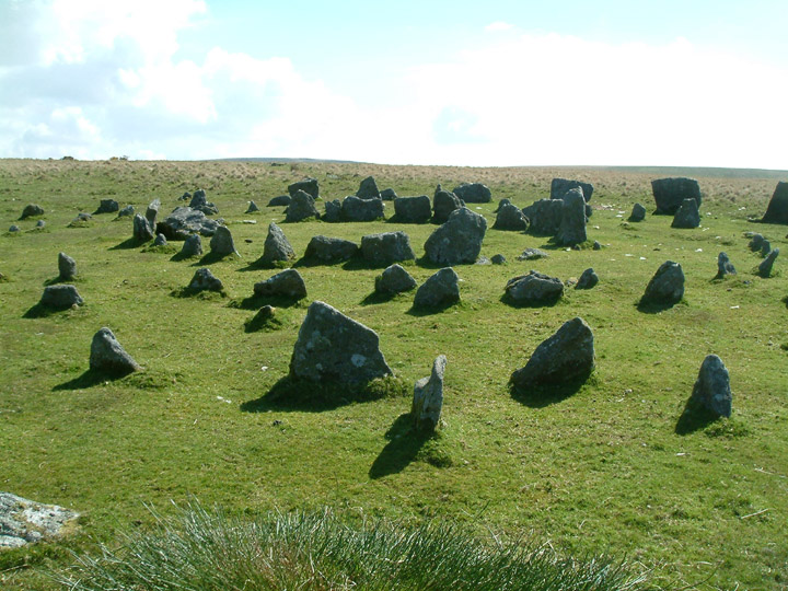
Of the circle itself, there are 23 of the original 26 stones still standing, none taller than about three foot. It is a wild area....lots of soggy ground all around, even on top of the hill. Not a place to go if you are not sure of your map reading skills...but if you are, well worth it, the landscape is stunning.

Looking north on a very murky day in May. the stone row starts its 2 mile run over the moor from just behind the circle.


Small cist found to the south of King Arthurs Hall. Burial chamber is surrounded by several stones in an area where quite a lot of stones lie at random on the open moorland.
King Arthurs Hall can be clearly seen on the ridge to the north.....but which came first?
17 May 2005
Visited this time from the road to the south...passing by the leaze cist on the way. Despite the wet spring that we have had, the hall is reasonably dry. Myself and Karen, a friend from Canada, decided to walk out into the centre of the hall. At one point I stuck my trusty stick down into the ground. After it had gone in about 4 feet I decided to pull it out...Karen stuck hers...then tried to pull it out. It broke and now remains sticking out of the “bog” like excaliber!
Has anybody ever put forward the idea that this could have been a pool?...the high banks and stones used to keep the animals out.
In 1240 a perambulation of the Bounds of the forest of Dartmoor was undertaken by 12 knights summoned by the Sheriff of Devon, under the orders of Henry III. Included in that perambulation was Elysburgh.