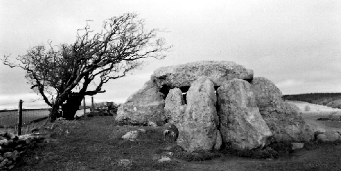


The hellstone – 22.12.2002, with the Hardy Monument visible through the gap.


The hellstone from a distance – 22.12.2002

Boscawen-ros menhir – 23.12.2002 – If you look hard you might just be able to make out the christian crosses burnt into the litchen....

Boscawen Un suspicious stone 2 – 23.12.2002 (see text below)

Boscawen Un suspicious stone 1 – 23.12.2002 (see text below)

Centre stone of Boscawen Un stone circle – 23.12.2002


Boscawen Un 2 – triangular stone – 23.12.2002


A third theory (see below for the other two) could be formed from a tradition heard by J.O. Halliwell and repeated in his book ‘Rambles In Western Cornwall’. This held that the bank was formerly higher, with its inner slope fashioned into rows of rough seating, similar to the medieval ‘Plen-an-gwarys’ [medieval ampitheatre]. If this was not the result of a later re-use of the site, the possibility exists that Bartinne was a sacred enclosure; indeed, legend tells us that no evil spirit can enter it. Fires were lit during the worship of the Celtic sun-god Belenos and it is worth noting that the name Bartinne has been interpreted as deriving from the Cornish ‘bre tanow’ -hill of fires.
Can be reached from many directions, the best of which might be from the track opposite the car park at the foot of Chapel Carn Brea then across Tredinney Common, keeping the disused china clay works on your right. Alternatively approach from Carn Euny.
This is what Craig Weatherhill says in his book ‘Belerion: Ancient Sites of Land’s End’ (Cornwall Books, 1981)...“On the summit of the hill is a circular area 75m across, marked out by a low bank of earth and scattered stones, which is nowhere more than 0.9m high. A shallow encircling ditch has virtually disapppeared. In the centre of the enclosure are three small circular banks of earth and gravel arranged in a tight triangular plan; the edges of two actually join. There is no sign of the ‘continuous stones pitched on end’ mentioned by Dr Borlase. The largest and best preserved of these circles, now containing the OS triangulation pillar, is 11.8m in diameter; the others are 7.9m and 9.1m across. Whether they are the remains of hut circles or ring barrows is not yet known.
What Bartinne Castle actually was is also a mystery. Even though the enclosing bank has been extensively robbed, it seems that it was never strong enough to have been of any defensive value. Perhaps, as Dr Borlase suggested, it was a hill fort, traced out, begun, but never finished. It could be that an alternative site was found at Caer Bran on the next hill. Another suggestion is that Bartinne may have been a huge disc barrow.
Marked on the Explorer map 102 as ‘cairns’ but it’s not obvious exactly where they are. They are on the summit of Trendrine Hill, probably best reached by the track leading uphill from the B3306 (2 km east of Zennor) to Sperris Croft Iron Age settlement, then bearing east along the ridge to the hilltop.
This is what Craig Weatherhill says in his book ‘Belerion: Ancient Sites of Land’s End’ (Cornwall Books, 1981)...“Two very large and prominent barrows stand on the hilltop, the largest of which is a great cairn of stones 19m across and 2.5m high, now topped by an OS triangulation pillar. Just to the south is another large mound 14m in diameter and 2.0m high, with a kerb of extremely large stones include natural outcrops. Parts of an inner retaining wall are also visible as are the remains of a central cist.”
Marked on the Explorer map 102 as a ‘cairn’. In a small triangular moorland plot beside the Trewellard branch of the B3318 near its junction with the Pendeen branch of the same road.
This is what Craig Weatherhill says in his book ‘Belerion: Ancient Sites of Land’s End’ (Cornwall Books, 1981)...“A very fine barrow, 12.2m in diameter and 0.8m high, with much of its stone kerb remaining. In the centre of the mound is a well preserved burial cist 1.2m long and 0.6m wide, roofed by a heavy capstone some 1.8m long. It is believed to have been excavated by W.C.Borlase, and a cupped stone (present whereabouts unknown) probably came from this barrow.”
Separately marked on the Explorer map 102 as ‘cairn’ and ‘tumulus’. They are beside the cliff path between Land’s End and Sennen Cove. On National Trust open land. Very close to Maen Castle cliff fort.
This is what Craig Weatherhill says in his book ‘Belerion: Ancient Sites of Land’s End’ (Cornwall Books, 1981)...“The most prominent of these two barrows stands immediately beside the cliff path.....7.9m in diameter and 0.6m high, it still has much of its kerb although most of the mound has gone. The roofless remains of a large cist are exposed to view. The second barrow is a low mound 9.1m in diameter and is north-east of its neighbour. These are probably the two barrows on Mayon Cliff excavated by W.C.Borlase in 1879, but nothing was found in either.”
Marked on the Explorer map 102 as ‘cairns’ but it’s not obvious exactly where they are. They are beside the cliff path between Porth Nanven and Whitesand Bay, just south of Polpry Cove. On National Trust open land.
This is what Craig Weatherhill says in his book ‘Belerion: Ancient Sites of Land’s End’ (Cornwall Books, 1981)...“Two barrows stand on the cliff top and both were excavated by W.C.Borlase in 1878. The northern barrow, on the landward side of the path is 10m in diameter and parts of both inner and outer retaining walls can still be seen. A cist was found in the centre of the barrow and a flat slab lying on the eastern edge of the mound may have been its capstone. Sherds of pottery were also uncovered. The southern mound, only 7m across, yielded an astonishing range of finds. This had been a kerbed ring mound raised around a natural boulder 1.2m high, and within it were four urns, three of them dating from the middle bronze Age, along with other fragments of pottery, a perforated stone, a leaf-shaped arrowhead, shale discs, pieces of glass, a steatite button and number of segmented faience beads.”
Marked on the Explorer map 102 as ‘Tumuli’. On a hilltop just south of the junction of the A3071 and the B3318.
Craig Weatherhill describes them slightly differently in his two books ‘Belerion: Ancient Sites of Land’s End’ (Cornwall Books, 1981) and Cornovia: Ancient Sites of Cornwall’ (Cornwall Books, 1985, revised 1997 & 2000), but the gist of it is this; four unusual and large disc / platform barrows, from 16 to 38m across, lie in a north-south line on the flat summit of Botrea Hill. All are low, flat topped mounds, none more than 1.2m high with remains of raised rims. Three of them were explored in the nineteenth century. Finds including ashes, a cist containing an urn and another cist in which were two fine barbed arrowheads. A couple of small bowl barrows lie just to the west. To the south-east there are three kerbed barrows, two of which are very large, with the third almost ploughed out. One of these also yielded an urn.
Local folklore says that there is a rift in the earth at the camp where the dead from a battle were thrown into.
I’ve also seen this refered to as Bury Wood Camp, and locals often call it ‘Bury Ditch’. This was an important hill fort of the Iron Age. Excavations under Dr Grant King explored it from 1959 onwards, and some of the finest Iron Age drystone walling was apparently unearthed. The height of the ramparts were about 5ft 8”.
In 1960 175 shards of pottery were recovered. All except one was plain coarse ware without a trace of decoration.
Just two fragments of human bones were found, whereas between 400 and 500 animal bone fragments were found. The vast majority were the usual domestic animals; sheep, goats, cattle, pigs, horses and dogs. Six specimens were of very large birds, probably swans or geese. Deer, fox, rabbit and vole bones were also spotted. The relative rarity of anything but domestic animals may suggest that the camp was based on stock keeping and that it was unlikely that hunting played a large part of the food economy of the camp.
‘The History of Colerne’ (1975 – no author) speculates that the camp may have been destroyed by the Second (Augusta) legion of the Roman army on their advance to Gloucester.
[NB- the Fosseway Roman road passes very close by – it’s the yellow road to the West, if you look on the multimap link]
The stones are just off the Bannerdown road (‘Holy Hill’), where tradition has it that St.Augustine met the British Bishops. This road is part of the Fosseway Roman road.
I was born in Colerne, the nearest village to the Three Shire Stones, so I know these stones well as a modern monument to mark the point where three shire counties meet – Wiltshire, Gloucestershire, and Somersetshire. Colerne was spelt ‘Cullerne’ in the Doomsday Book, hence the few genuine Colerne survivors pronounce it ‘Cullern’ whereas the Bath-ites pronounce it ‘Col-arne’. Excuse my bitterness but I am annoyed that there is no way I can afford to live in the village where my heritage comes from (‘Bull’ is one of the traditional Colerne names).
Anyway enough of my soapbox, I hadn’t thought much about the Three Shire Stones possibly being based on an ancient monument until I read the ‘History of Colerne’ (no author) which says the stones are recorded as a burial chamber on an OS map of Neolithic Wessex and that a tentative date may be given of 2,000 BC. I have nothing else to back this up but will start looking. It is not included in Dr Glyn Daniel’s book, “The Prehistoric Chambered Tombs of England and Wales”. The present stones are certainly modern, apparently erected by public subscription in the Victorian era, and the ‘History of Colerne’ says it superseded three smaller stones which were allowed to remain undisturbed beneath the central slab.
Marked on the Explorer map 102 as ‘Tumuli’. On croftland fields, not far from a public footpath that runs between the side road (between Treen and New Mills, not far from the B3306) to Bosporthennis.
This is what Craig Weatherhill says in his book ‘Belerion: Ancient Sites of Land’s End’ (Cornwall Books, 1981)...“There are four barrows here, two so mutilated that is impossible to tell whether they were ever chambered. The other two are unmistakably entrance graves. The southern tomb is the best preserved, with a find mound 7.6m across and 1.3m high, containing a chamber 4.9m long and 0.9m high. The three large roof slabs are exposed at the top of the mound which has lost its retaining kerb. The chamber entrance, on the North side of the barrow, is restricted in width by two low jambstones. The north tomb, 61m to the north-west is 6.1m in diameter and just 1.1m high. Only the inner end of the chamber, with one roof stone remaining, is left. It was entered from the south-west.”
The chamber of the south tomb faces north-west. Both ‘Belerion’ and ‘Cornovia’ contain pictures and drawing of the tombs.
Tregiffian Vean Scillonian Chamber Tomb
Marked on the Explorer map 102 as ‘Chambered Cairn’. In a field, not far from a public footpath that runs between Higher Tregiffian Farm and Tregiffian Hotel. Higher Tregiffian Farm is just off the B3306, close to its junction with the main A30.
This is what Craig Weatherhill says in his book ‘Belerion: Ancient Sites of Land’s End’ (Cornwall Books, 1981).... “This barrow has suffered dreadfully and it is only a shadow of the fine and unusual monument excavated by W.C.Borlase in 1878. It was then a kerbed mound 6.4m in diameter, containing a rather odd-shaped chamber. This was 2.4m long, 0.9m wide and just 0.5m high, but its inner end opened out to a width of 1.2m and a height of 1.0m. Like the tomb at Tregeseal the entrance was blocked by a single slab. The roof of the chamber consisted of three slabs and the tomb contained ashes and an urn. Today this barrow is in a sorry state. All that remains of the chamber is a short passage covered by a granite slab 1.4m long and 1.2m wide, supported by two stones on each side (those on the west side have fallen, one projecting from beneath the capstone). A slab on the edge just to the north east of the capstone may be in its original position. The chamber is open at the north end, the southern end being blocked by the ploughed remains of the mound which is now about 4.6m across and just 0.6m high”.
Has anyone been to this more recently? What does it look like today? The picture in Belerion makes it look a sorry state and that was over 20 years ago!
After the find an excavation unearthed a burial site in a round barrow near to where the cup was discovered. One side of the cup had been crushed, probably by agricultural work in the field which dragged it from its original site; otherwise it is intact. The cup is strikingly similar to the Rillaton Cup, which is of a similar date, shape, size and design. Both have broad handles attached with lozenge shaped rivets, and were beaten out of a single piece of gold. The Ringlemere Cup is slightly larger though, and has a curved base. It is thought that the Rillaton Cup, which has a flat base, could originally have had a curved base.
Archaeologists found a grave containing fragmentary bones, possibly human. Though no whole skeleton has yet come to light this may be because bones have been dispersed by animals, or eroded by acidic soil. Excavation of the barrow also produced Mesolithic and late Neolithic flint tools and pottery, showing that people have been living near the field at Ringlemere Farm since at least 5,000 BC.
I have also seen this referred to as the ‘Woodnesborough Cup’ (Woodnesborough is the closest village to the farm) and the ‘Kent Cup’. The farm belongs to the Smith family, who agreed to both the metal detectors’ search, and the subsequent excavations which have now been back filled.
Said to ensure fertility, particularly to newly married couples, but only after they have squeezed their naked bodies through the hole.
This is what Craig Weatherhill says in his book ‘Cornovia: Ancient Sites of Cornwall’ (Cornwall Books, 1985, revised 1997 & 2000): “In the back garden of Tolvan Cross Cottage, on a minor road 1mile due North of Gweek. Permission to view must be sought. A large upright slab, triangular in shape, 2.3m tall and 2.2m wide at the base. The centre of the stone is pierced by a circular hole 44cms in diameter, the purpose of which is unknown. It is probably Bronze Age.”
Homer Sykes in ‘Mysterious Britain’ (Weidenfeld & Nicolson, 1993) says that it is unknown how far into the ground it stands, and that the hole is bevelled. He says that some suggest the Tolvan was used to block a now lost ancient burial chamber, and suggests that the hole allowed a way in for funeral purposes and a passage out for the spirits of the dead. An interesting idea but strange that nothing else like it exists elsewhere.
One of only three surviving henges in Cornwall, along with Castilly Henge and the Stripple Stones. This is what Craig Weatherhill says in his book ‘Cornovia: Ancient Sites of Cornwall’ (Cornwall Books, 1985, revised 1997 & 2000):
“1 mile SE of Callington on the A388, from the S side of which a lane leads to Westcott. Site lies on hillside to N. First recognised as a Neolithic henge in 1951, the somewhat ploughed down bank and internal ditch cover an area 90m in diameter. An indistinct entrance occurs on the south side, but there appears to be no corresponding causeway over the ditch. There is no visible evidence to suggest that there were any internal stone or timber settings. Like Cornwall’s other two surviving henges...this site was positioned close to a major prehistoric trackway; trade may have played a part in the function of the henge. Balstone Down, close to the north, was the source of greenstone for the manufacture of Neolithic axes. The bank of the henge reaches a height of 1.0m; the maximum depth of the ditch is 1.2m.
One of only three surviving henges in Cornwall, along with Castlewich Henge and the Stripple Stones. This is what Craig Weatherhill says in his book ‘Cornovia: Ancient Sites of Cornwall’ (Cornwall Books, 1985, revised 1997 & 2000):
“Above the W side of the A391, just S of its junction with the A30. The site is clearly visible from the A30. An oval earthwork with a maximum diameter of 66m. The surrounding bank is 1.8m high; the internal ditch is 2.1m deep and 5.5m wide. The flat featureless central area measures 49m by 29m. The broad opening on the north-west side is the original entrance; the smaller south-eastern gap dates from about the thirteenth century when the site was remodelled for use as a plen-an-gwary (medieval amphitheatre). It was adapted again, this time for defensive purposes, during the Civil War. The henge, recognised as such in 1954, was excavated in 1962 but its Neolithic origin was not conclusively proved. Sited on a north-facing slope, it lies near the junction of two major prehistoric trackways and was formerly surrounded by several round barrows, few of which remain.”
In chamber 3 you will see the Witch of Wookey who, according to legend, was turned to stone by a monk from Glastonbury Abbey.
Excellent close up pic of the cup, all spic and span
I realise this is cheating a bit by adding on a site that isn’t really open, or doesn’t necessarily have anything to see, but Ringlemere Farm is where the famous ‘Ringlemere Cup’ was found in 2002. The cup bears a very striking similarity to the Rillaton Cup, found at Rillaton barrow on Bodmin Moor.
This cave is close to the B3134 (not far from the junction with the A368) just 4 kms North of Cheddar Gorge. It was occupied in palaeolithic times.
Research document chronicling one of Europe’s most important Bronze Age excavations went up in smoke in 2000. What an awful story!
Britain’s oldest complete skeleton, ‘Cheddar Man’, was buried in Gough’s Cave 9,000 years ago and discovered in 1903. Humans lived in the caves for 40,000 years, leaving behind many stone-and-bone clues to their lifestyle. DNA tests in 1997 established that Cheddar Man still has descendants living in Cheddar.
It seems like Gough’s cave is now part of the whole Cheddar Gorge ‘tourist experience’. The ‘Caves & Gorge Explorer Ticket’ allowing access to everything (i.e. including Gough’s Cave) cost almost £9 for an adult in 2002. It is open all year though.
Janet & Colin Bord’s 1978 book, ‘A Guide to Ancient Sites in Britain’ says that it’s a long way back in time from the relatively recent occupation of Wookey Hole to the occupation of the nearby Hyena Den, a small cave which was occupied during the Old Stone Age, 400,000 years ago. Hyena Den, with its 30cm thick bed of bones, was discovered by the workmen digging the canal. Excavations in 1852 brought to light the bones of many Ice Age animals – cave lions and bears, mammoths, bison, hyenas, wooly rhinoceroses, elk and others – as well as flint implements. Archaeologists reckon that the cave was occupied by hyenas and man alternatively between 35,000 and 25,000 BC. It seems that packs of hyenas drove their prey over the cliff edge and then ate the remains. There is also a theory that early man may have done the same.
In several parts of Britain there are caves which are known to have been occupied at various periods during the last 400,000 years. Wookey Hole is easy to visit as it’s a famous tourist attraction.
The Wookey Hole Caves site has provided rich pickings for archaeologists and anthropologists over the years, and several exciting excavations have been undertaken.
Only the first chamber, lit by daylight, was occupied. In 1912 an archaeologist Herbert Balch excavated the site. Pottery found there dates this occupation to the late Iron Age and into the time after the Roman occupation. The discovery of the bones of two goats, a pot, and the remains of a tethering post indicate that part of the outer chamber had also been used as a goat pen; and nearby was found an almost complete skeleton of an old woman, plus a dagger, knife, billhook and a stalagmite / alabaster ball (whatever that is!).
Workmen digging the canal in 1857 found the remains of prehistoric man, including flint tools, as well as the bones of animals such as hyenas, mammoths, rhinoceros and lions.
Many of these are now on display at the nearby Wells City Museum, but most were retained and are now housed in Wookey Hole Cave’s own museum. The museum has various displays giving more information about the history of the caves, archaeological excavations (including artefacts) and cave diving.
Kents Cavern is one of the most important Palaeolithic caves in Northern Europe and the oldest recognisable human dwelling in Britain. Kent’s Cavern is in Ilsham Rd, off Babbacombe Rd in Torquay. It was occupied during Palaeolithic times. Janet & Colin Bord’s 1978 book, ‘A Guide to Ancient Sites in Britain’ says that finds can be seen in the Museum of Torquay Natural History Society in Babbacombe Rd but I’m not sure if that’s out of date now.
It holds beautiful and spectacular geological formations and significant prehistoric finds, some over 700,000 years old.
The cavern has been visited by loads of celebs, including Beatrix Potter, Agatha Christie, King George V, and HIM Haile Selassie I. You can even hold birthday parties there and corporate cocktail receptions.....
Open all year, except Christmas Day; currently (2004) £6 for adults. Check out the web link below for more info.
‘Ancient Places’ by Prof Glyn Daniel and Dr Paul Bahn (1987, Constable and Company) mentions a folklore tale that says infertile women can be cured by touching the stones with their bare breasts. In the Eighteenth Century the local young people used to meet near the King Stone on Midsummer’s Eve for dancing and feasting.
‘Ancient Places’ by Prof Glyn Daniel and Dr Paul Bahn (1987, Constable and Company) also mentions the stories and different names that Rhiannon recounts above. They also say that the rectangular chamber stood at the Eastern end of a mound which was about 27m long. Some human remains and coarse potsherds were found here.
Details on the The Treasure Act 1996 – All finders of gold and silver objects, and groups of coins from the same finds, over 300 years old, have a legal obligation to report such items under the Treasure Act 1996. Now prehistoric base-metal assemblages found after 1st January 2003 also qualify as Treasure.
‘Archaeology Alive’ – the Annual review of the fieldwork, projects, conservation and advice work carried out by the Historic Environment Service (including Cornwall Archaeological Unit) in Cornwall & Scilly. For the first time a free online version of the latest copy (2000-2001) is available. Back copies can also be purchased.
The homepage of the Cornwall Archeological Unit, which is part of the Historic Environment Section of Cornwall County Council. Loads of interesting news and info, and over thirty publications available to buy.