


View from the northeast. The northern barrow is on the right, central barrow to the left.

View from the crater of the south barrow looking eastwards towards Robin Hood’s Bay with Brow Moor on the right edge of picture.
The OS 1:50000 map shows two barrows here but there are actually three that stand in an almost north-south line along Foster Howes Ridge with the land falling away gently on each side. The barrows are visible from some distance, particularly when approached from the northwest when they are silhouetted on the skyline and there are fine views across Goathland Moor to the southwest and down to the sea at Robin Hoods Bay to the east from the barrows themselves.
When approached by track from this northwest direction it is the smaller northern barrow that is met with first, with the central barrow just beyond it but on the other side of the fence. The third (and largest) barrow stands a little further away just to the west of a gate and stile. This southernmost barrow also had a stone kerb although a very quick rummage through the heather only turned up one stone – there may be more. All three barrows show the signs of previous diggings with craters in the top, the one to the south has a rough looking boundary stone in it’s crater, the central barrow is also said to have it’s own stone although I can’t confirm this.
EH gives the following measurements for the barrows.
North – 12 metres diameter and .75 metres high with a 2 metre wide ditch on the south side.
Centre – 20 metres wide and 1.75 metres tall with traces of a 2 metre wide ditch.
South – 20 metres diameter and 2 metres high with traces of a 2 metre wide ditch.
This is a difficult mound to photograph as it is so badly covered in heather and is also the most low lying barrow of the group, indeed if you draw a line linking all the barrows together then Robbed Howe marks the lowest point of that line – from here it’s uphill in either direction.


The smaller stone here has been so regularly shaped that it would be impossible to tell if it had a prehistoric origin. The larger stone is a difficult one to call as far as I’m concerned, it may be prehistoric but has been tooled on one face and at least one side with the face bearing an inscription from 1784. The barrow is also a little suspicious due to it’s size and the fact that although it’s marked as tumulus on the map it doesn’t appear in my copy of the SMR.
Scratch head and file under Hmmm....
This is the easiest barrow of this group to visit as it stands just a few metres to the west of a small car parking area next to the Whitby – Goathland road. EH says it measures about 13 metres by 1 metre tall and like many of these barrows has a large hollow in its top – the result of antiquarian excavations or plundering in the past. While Breckon Howe is clearly visible from here, I don’t think the next barrow in the chain, Flass Brow, can be seen from this point (I need to check the sightline again)
Although Sil Howe appears on the SMR it is not shown on either the 1:50000 or 1:25000 OS maps. This seems rather strange as it was formerly the home of the Lilla cross between 1952-1962 which would have been a prominent local landmark.

Canon Greenwell writing in 1890 mentions the following in respect to carved rocks in the area –
“Eight stones with these markings are preserved in the gardens at Peak House, or, as it is now usually called, Raven Hall, some of which are said to have been taken out of neighbouring barrows.”
So where did the other seven carved rocks go?
Although there remains nothing to see on the ground this is nevertheless an important site in the understanding and unfolding story of prehistoric Lincolnshire. It was first discovered by the aerial photography of crop marks in the 1970’s that revealed a slightly oval area measuring about 25 metres in diameter surrounded by a 2 metre wide segmented ditch with entrances to the northwest and southeast, making this a Class II henge. No trace of the external bank that we might expect to find associated with this type of monument has been found but we could reasonably assume that this would have extended the size of the monument by another 2-3 metres on either side. Just beyond this proposed bank was discovered a ring of 24 pits or post holes, whether these were originally left as pits, perhaps for ceremonial offerings, or used to support wooden posts is not known at present but an extract from English Heritage’s scheduling report of the site tantalisingly suggests that they may have held standing stones. Personally I think this is highly unlikely as there appears to be almost no tradition of the use of stone within Lincolnshire (or at least no surviving evidence) – it is not used at other sites, so why here, and where would this stone have come from?
Looking at aerial photographs of the site shows what looks like the dried remains of a stream or river just to the east of the current course of the River Bain – was this the original course of the river? If so then the henge was closer to the Bain than it is now and this might strengthen the argument that this site was somehow linked to other sites that could be associated with the Bain such as Grim’s Mound and Ludford Barrow further north.

Panorama with rain threatening from the west.
Panorama from beside the stones.


Compare this picture with Fitz’s taken two years previously, looks like the site owners are happy to let the stone vanish behind the foliage.
Panorama of the circle, early morning April 2003
360 degree panorama from the centre of the circle.

I came across this carving on the way back from the Twelve Apostles to the Cow and Calf and haven’t got an exact position for it, but it would be interesting to see what condition it is in now as this picture was taken in Feb 2004. Not sure how fresh the carving was or who did it (Ray Mears maybe??) but it struck me how much contrast there was between the carved area and the surrounding stone and made me think again about how the stones on the moor would have looked when their cups, rings and ladders were first pecked out.

This was about the best I could do to see the patterns.
Feb 2004

The design on this stone is almost invisible now if the light isn’t just right – here you can just about make out some of the rings to the right of the rock.
Paulus’ advice is to visit this one on a wet day and catch it in low sunlight – I managed to visit on a dry February day late in the afternoon when the sun was coming in from the wrong direction. Some of the rings are just about visible and can be traced with a finger but the design is incredibly worn – shame.
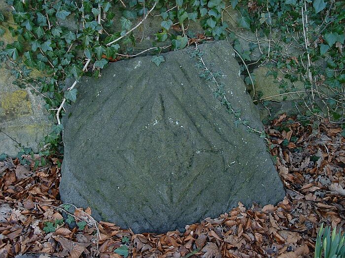
This is an interesting stone propped up against a wall on the edge of the churchyard close to the ‘plague stone’. It consists of a central cross within a diamond shape with the centre carved into a shallow depression, further grooves continue the diamond shape out towards the edge of the stone. I wasn’t sure if it was prehistoric when I saw it but PRAWR has it recorded as stone 208 and says that Eric Cowling suggested it may have been a cist cover.
Easy enough to find in the churchyard, PRAWR says this stands ‘among other stones of interest’. The only other stone I could find here was the lozenge stone (208 in the classification) that stands a few feet away, the rest are all medieval from what I remember.


360 degree panorama of Maen Ceti – August 2004
360 degree panorama of St. Lythans – August 2004
360 degree panorama of Tinkinswood – August 2004
This is an odd one – perched on top of a 30 foot chalk quarry face on the edge of a nature reserve. The quarry was once the site of chalk extraction, which was then burned to make agricultural lime and it was while digging around the base of the barrow in the early 20th century that a grave containing a crouched skeleton and a beaker pot was discovered. It is said that the pot (later dated to around 1600BC) rolled down the chalk face and was damaged while the unfortunate occupant of the grave later received a burial in the local churchyard. I don’t know why the quarrymen didn’t continue digging away at the barrow but I would hazard a guess that they didn’t want to disturb any more bodies.
What’s left of the barrow now measures about 15 metres in diameter, stands a metre tall and is situated on a northwest-southeast spur of land overlooking the valley of Burlands Beck. This same spur is also the location of the Deadmen’s Grave long barrows about 500 metres to the northwest.


This is quite a large barrow that has managed to survive intensive agriculture as well as excavation and people riding trials bikes over it in recent years. Measuring between 30 and 35 metres in diameter the oval mound is still a couple of metres tall with the large depression in one side resulting from archaeological investigations in 1941. Although the land that the barrow stands on is fairly flat it seems that the close proximity of the source of the River Bain just a few hundred metres to the north west and the ancient trackway known as ‘High Street’ just to the south west might well have been the reason for its location here.
The barrow is believed to have been reused as the base of a set of gallows and more recently the site’s association with death continued in the early 1960’s when a nuclear missile launch site was commissioned less than a mile to the south east (don’t worry, they’re long gone).

I have to admit that this is a new one to me, I’ve never expected any barrows in this part of the county and hence never bothered looking, but here it is, marked on the map (though not as tumulus) too, which is even more of a surprise. It stands on a slight rise and can be see from some distance due to the trees growing on it but unusually for barrows in the county it is not associated with any streams or rivers, the nearest one is 2-3 miles away. English Heritage say it measures about 17 by 11 metres and stands around 2 metres high.
This is a nice barrow in a pleasant spot standing on gently eastward sloping land between 2 tributaries of the River Lymn with some great views of the surrounding countryside. The barrow itself is oval measuring roughly 30 metres by 20 metres (probably the result of plough damage) and stands about a couple of metres tall with a sizeable depression in its top. It is though that this is the result of the barrow being used as the base for a windmill at some time in the past, indeed it is marked on the OS map as ‘mill mound’.


Not really much to see at this barrow – a slight hump in the field is all that left.


