


360 degree panorama from next to the barrow.
This chap tracked the stone down but doesn’t give it’s position. If you email him he says he’ll give you directions though.
I’ve got to say the modern photo doesn’t really look like if was part of the original Sack Stone judging from the 1890’s picture unless it was the lowest section – which isn’t too clear in the old pic.
The picture from C. Phillips report on Lincolnshire published in 1932 says that the stone stood ‘until recently’ which would vaguely tie in with Grays assertion that it was broken up in 1917. He also states that although it stood on chalk land it was formed from ironstone which occurs several miles away concluding that it was either moved here and then erected or that it was a glacial erratic. He goes on to say that it ‘did not exceed 3 feet in height and was a cheesewring of three superimposed pieces of stone’ that was ‘religiously removed during ploughing and then replaced in position before it finally fell to pieces’.

This picture from around 1890 appears in C. Phillips study of Lincolnshire published in 1932
360 degree panorama around Grim’s Mound
This barrow has often fallen in to ‘is it or isn’t it’ category. It’s shape and position are not typical of the Lincolnshire long barrows being a lengthened oval rather than trapezoid and standing on greensand rather than the chalk of the other barrows in the region. C. Phillips writing in 1932 likened it to several barrows in east Yorkshire while P. Phillips (I’m assuming they are related) said in 1989 that excavations had proved inconclusive, further in 1998 Dilwyn Jones failed to mention the site in his study of the long barrows of the area (although he also missed out at least one other recognised barrow).
English Heritage on the other hand have no doubts and list it as a definite long barrow giving its measurements as 65 metres by 20 metres with a maximum height of about one and a half metres and aligned south-east to north-west.
As with many other Neolithic and Bronze Age sites in Lincolnshire it is close to the prehistoric trackway known as High Street and also stands close to the head of a valley that marks one of the sources of Kingerby Beck – the kind of position common to local barrows.
A nicely preserved barrow about 20 metres in diameter and just over 2 metres high standing next to the Viking way and to the north-east of the village of Burgh-on-Bain. The piece of land that the barrow stands on is a north-south spur that extends between the valleys of the River Bain to the west and one of it’s tributaries to the east ending where the Bain cuts eastward then south again at the deserted medieval village of Biscathorpe a mile or so to the south. This gives the site an impressive 360 degree view of the surrounding countryside which is rich in chalk and flint – indeed English Heritage say that there have been several finds of worked flint from the soil around the barrow.
The name of this barrow alludes to Grim, the legendary founder of Grimsby who is said to have fled Denmark and settled there with the young prince Havlock after the Danish king was killed in an invasion.
Further to what Dave says English Heritage only records a single barrow here – the round barrow to the east of the track. It has indeed been almost destroyed by ploughing with the earth and chalk body of the mound being spread across an area of 30-40 metres. If you crouch down though you can still see a slight hump in the field against the horizon.
The barrows position is interesting as while the land drops away by a nearly a hundred metres within a mile to the west to the River Bain, the barrow is just below the eastern crest of the hill and seems positioned to overlook a series of 5 or 6 valleys on this more gently sloping side of the hill. What could be more important however is that between the barrow and these valleys is a minor road that runs roughly northwest-southeast along a flattened ridge that was formerly used as a prehistoric trackway along this part of the Wolds. This trackway is now known as ‘Bluestone Heath Road’ and runs almost parallel to the ‘High Street’ trackway 3 miles to the east on the other side of the Bain but it appears that it was either felt to be less important and attracted less barrows or if they existed here in the past they have now been lost.
Fact fans: The large dishes close to the barrow that look like they come from a sci-fi filmset formed part of a cold war microwave communications system code named ‘Ace High’. They can be seen on the goole map photo to the northwest of the barrow.
This is a smallish barrow measuring 15 metres by 1 metre high with slight traces of a ditch to the north and south that stands on a parish boundary just outside the village of Buslingthorpe. The first thing that is noticeable is how flat the land is, in the surrounding square mile the elevation doesn’t rise or fall much more than a couple of metres either way. What there is round here however is plenty of water, the barrow is sited almost exactly half way between 2 tributaries of Barlings Eau – I’m assuming that these existed when the barrow was built and are not a result of more recent land drainage.
This is one of the tallest remaining barrows in the county despite, or because of, it’s use as a ROC monitoring post. When the post was constructed in the late 1950’s a large trench some 7 metres long and 3 metres deep was gouged out of the top of the monument and it could be that the height of the barrow was slightly increased in the process of building. Whatever, it stands a respectable 3 metres high with a circumference of 20 metres on the edge of a field next to the B1225 – an ancient trackway with several round and long barrows associated with it. It also marks the highest point in the immediate area with the land sloping away westward to a tributary of the river Witham and eastwards towards the River Bain.
Fact fans: The Belmont aerial mast just to the southeast is the tallest structure in Europe.
The grid reference given for this site is the northmost and most prominent of the 2 round barrows, which isn’t marked on the OS map. The barrow to the south at TF215845, which is marked on the map, is just about lost on the edge of a small copse and likely to vanish even more as the tree cover increases.
The northern barrow stands in isolation in a field and has three large trees growing from the mound which measures about 14 metres in diameter and just over a metre tall. The southern barrow is larger at around 22 metres in diameter but is lower at under a metre in height. Both of these monuments are less than a hundred metres from the prehistoric trackway now know as High Street and less than half a mile south from Burgh on Bain long barrow. At this point on the trackway the land slopes down on either side – to a tributary of the River Witham on the west and to the River Bain on the east.
This is a nicely preserved barrow that unlike many in the county is easily accessible as it stands next to the B1225, a road that is now recognised as an ancient trackway. Although it can become overgrown in summer a visit in winter or early spring reveals a 25 metre diameter mound rising to 2 metres in height and the sides seem to have suffered only minimal damage over the years. There are some fine views to the east towards the valley of the fledgling Waithe Beck about a mile away and while the western view is obscured by bushes the barrow is in fact only about 400 metres away from the valley of the River Rase.
One of the smaller long barrows in Lincolnshire, this oval mound is only 27 metres long and 14 metres at its widest point. It stands around 2 metres tall (underneath the grass and bushes) and is ringed by 5 largish trees that have probably protected it from agricultural damage for a good few years.
Aligned wsw-ene it is situated on a ridge that slopes down to the valley of the River Bain about a mile away to the west, and is less than 100 metres from the ancient trackway of High Street. This trackway, that runs along the spine of the Wolds, is rich in round barrows and 3 stand within a few hundred metres to the south.
Note: This long barrow is marked on the OS Map as ‘tumulus‘
This is the most northerly of the Lincolnshire long barrows and stands in a copse on the eastern edge of a dry valley that now cuts across the road that runs from Swallow to Thorganby. It is also the shortest of the regions Neolithic barrows being about 24 metres long by 12 metres wide at its southern end and 6 metres wide at the north. At it’s highest point it is just under a metre and a half tall and has a large pit dug into the southern end.
The alignment of ssw – nne seems unusual but it allows the barrow to follow the contour of the ridge, this seems to have been the most important criteria for the builders.
The site is quite overgrown and can be difficult to find – park at the southern end of the copse and follow the line of undergrowth uphill for a short distance before heading under the trees.
On the opposite side of the Waithe Beck valley from Hoe Hill barrow, Ash Hill is around 40 metres long, 16 metres wide to the north-east trailing to 10 metres wide at the south-west and stands about 2 metres tall. C. W. Phillips reported in 1932 that there were a number of large trees growing from the mound and that rabbits were ‘burrowing freely’ in several places.


Picture taken from slightly below the level of the cave to get the whole of the fissure in shot.
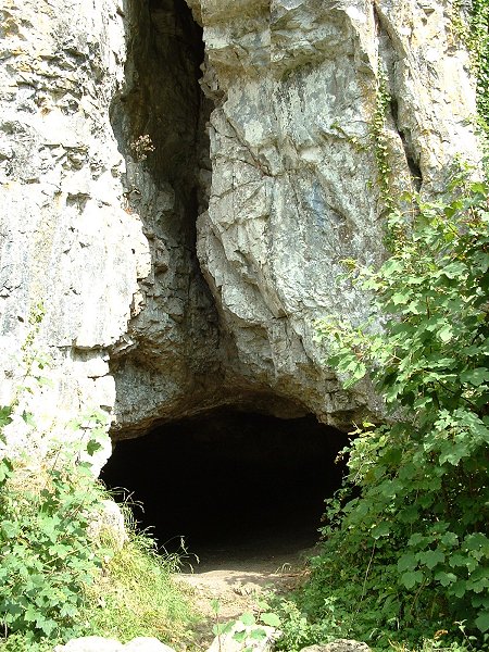

Entrance to the cave. From memory I think it extends about 20 feet back into the darkness.

A transcript of J. Horsfall Turner’s “Ancient Bingley” published in 1897. Only the first 20-30 pages of this .pdf document are relevant, the rest is more recent stuff.
360 Degree Panorama of Mayburgh Henge.
360 Degree panorama of the circle.


The barrow seen from a lower level as the land falls away slightly.

The barrow seen from roughly the same level. The top looks to have been slightly flattened.
This is a strange one. One of the largest round barrows in Lincolnshire and it doesn’t even appear on the OS Landranger maps, plus it has never been damaged by ploughing and there are no records of any excavation or signs of pillage. It sits on private land behind Hatcliffe Manor House but can be seen from the road that runs between Hatcliffe and Binbrook and from a farm track leading west from the road. Even from a distance it is large and impressive – the most impressive that I’ve seen in Lincolnshire (a county not renowned for its round barrows) being about 30 metres wide and 3 metres high although being on a slight rise it looks taller from some angles. The top seems to have been slightly levelled, whether this is how it was originally built or has been caused by wind and rain erosion over the centuries is unclear. It’s difficult to see what was going on here, there don’t seem to be any other barrows in the area apart from the earlier Ash Holt longbarrow a mile and a half to the northwest and there are more prominent locations nearby. The barrow can however be seen from a wide area and it also sits close to a 90 degree bend in the nearby Waithe Beck. Was this the reason for the position of the barrow?
From the BBC -
‘The Neanderthals were not close relatives of modern humans and represent a single species quite distinct from our own, scientists say.
3D comparisons of Neanderthal, modern human and other primate skulls confirm theories that the ancient people were a breed apart, the researchers report.
Others claim Neanderthals contributed significantly to the modern gene pool. ‘
Those scientists just can’t seem to agree on Neanderthals. Full story at -


The three banks, the inner in on the bottom right of the picture. Looking West.
Nice aerial view of the camp/fort/settlement.
This well preserved set of earthworks is marked on the map as ‘fort’ and James Dyer calls it an Iron Age Hillfort but I would think it falls more into the category of defended settlement. The best approach to the site is to park on rough land at the start of the track at SK948431, the track then leads uphill and to the southeast. It takes a sharp right turn as the land levels off and continues along the side of a small wood for about 600 metres before turning left and leading 500 metres to the earthwork. The track is rutted and very muddy in places and would be unsuitable for wheelchair users.
The site sits below and to the northeast of the highest point of Barkston Heath and consists of a small roughly rectangular set of banks and ditches enclosing an area of 0.4-0.5 hectares. The earthworks themselves comprise of an inner bank, ditch, larger central bank, ditch and then a lower outer bank or counterscarp. There is an entrance through the eastern defences and the ditches are still a couple of metres deep in places, the whole site being in remarkably good condition considering its exposed position and the fact that it sits on a gentle slope in good farming land. I can’t see that its primary purpose was as a stronghold though, there are some decent views to the north and east but the middle distance view to the west is blocked and that to the south isn’t fantastic and anyway the defences look like they could easily be overcome. I got the impression that it would be better suited to a small family group, perhaps farmers who were cultivating the lower slopes to the east that are now taken up with an airfield. Finds from the site include some Roman coins (Ermine Street runs about a mile to the east) as well as remains of (Iron Age?) weapons.
From the BBC-
Neanderthals were shedding their sturdy physique and evolving in the direction of modern humans just before they disappeared from the fossil record.
Newly-identified remains from Vindija in Croatia, which date to between 42,000 and 28,000 years ago, are more delicate than “classic” Neanderthals.
One controversial explanation is that these Neanderthals were interbreeding with modern humans in the region.
Full story at -
From the BBC-
A flint object with a striking likeness to a human face may be one of the best examples of art by Neanderthal man ever found, the journal Antiquity reports.
The “mask”, which is dated to be about 35,000 years old, was recovered on the banks of the Loire at La Roche-Cotard.
It is about 10 cm tall and wide and has a bone splinter rammed through a hole, making the rock look as if it has eyes.
Commentators say the object shows the Neanderthals were more sophisticated than their caveman image suggests.
“It should finally nail the lie that Neanderthals had no art,” Paul Bahn, the British rock art expert, told BBC News Online. “It is an enormously important object.”
Full story on the BBC website at-
news.bbc.co.uk/1/hi/sci/tech/3256228.stm

Could be nothing, but . . . on the east side of the monolith and at about shoulder/head height is this small groove (I’m guessing about 6-8 inches long). It could be natural but the fault lines on the stone run from top left to bottom right on this side and this mark is vertical and looks quite different. Was it caused by the tip of a stone axe?