Visited in September 2007 and Ministry of Works sign had been removed so can’t be used as a waymarker to find the cairn and nearby Wet Withens. The cairn itself has been bashed about and it’s difficult to figure out what it was meant to be. There is a suggestion that it may originally have been a pair of cairns that were either joined in antiquity or by more recent excavation/quarrying while another idea is that it could have been a long cairn. It measures about 28 metres by 18 metres.
Chris Collyer
Found this news item from 1998 concerning Bradup circle.
archive.thetelegraphandargus.co.uk/1998/1/31/178175.html
-----------------------------------------
“A historic moorland stone circle has vanished.
Walkers and local residents are unable to find the Bradup circle – dubbed ‘Riddlesden’s Stonehenge’ – which used to be a few yards off Ilkley Road on Rombalds Moor.
Hilary Simpson, who lives near the bronze age site, is appealing to Keighley News readers for information about its disappearance. She believes it was disturbed by contractors digging a gas pipeline across the moor almost three decades ago.
Other theories put forward by residents and visitors include:
theft by pagan worshippers
rockery thieves
their removal by a former landowner.
Mrs Simpson, of Bradup Farm, says sun worshippers visited the site after she moved in 12 years ago, but couldn’t find the circle. “Every so often someone knocks on my door and asks where it is,” she says. “The stone circle will have been here for thousands of years. Friends and locals remember it clearly up to about the late 1960s. Somebody must be responsible for it being removed, and for the sake of heritage someone must be made to reinstate it.”
Former Riddlesden resident Ken Pickles, who has walked the moors all his life, also believes the circle vanished around the time the gas pipe was laid. “I first walked this moor in 1945,” he says. “In the late 1960s there were definitely 12 there. It was a perfect stone circle. It offends me that children should be denied things like this. It was Riddlesden’s Stonehenge.”
The stone circle has been marked on Ordnance Survey maps for many years though recent editions have described it as ‘remains’. There were originally 18 stones but by 1929 just 12 remained, the others used in the construction of nearby Bradup Bridge.
A stone circle expert who visited in the early 1990s found what he believed to be the site, but just one stone remained next to a pile of rubbish and oil drums. Another possible site is a few yards west, where several large stones lay strewn in the thick heather.
Gavin Edwards, Bradford council’s archaeology officer, says he tried to survey the circle 20 years ago as a student, but his team was unsure it had found the right place. He says: “It was a bit enigmatic. It’s a few stones. Even reports in the 1930s described it as very damaged.”
Mr Edwards says the Bradup site could not strictly be called a ‘stone circle’ but was more likely a prehistoric burial ground. He believes his council predecessors liaised with British Gas to ensure the pipeline avoided historic sites on Rombalds Moor.
British Gas spokesman John O’Grady says workmen laying the pipe in 1971 could not have damaged the stone circle because they worked within a strict 45-foot-wide corridor containing all their machinery. He says the original contractors’ map shows the Bradup circle as ‘remains’, 100 feet south of the edge of their corridor.
But Mrs Simpson claims the only access from Ilkley Road to the construction site would have been from a farm gate on the other side of the stones. A direct route from the gate to the work site would have been across land occupied by the circle.”
-----------------------------------------
Several of us (including me) have been quick to point a finger of suspicion at the owners of the local farm concerning the disappearance of these stones but it seems that they are just as concerned about what happened to them as us. Apologies are duly offered.
Germany: DNA used to trace modern descendants of Bronze Age remains.
news.bbc.co.uk/1/hi/sci/tech/7573772.stm
BBC video clip of interview with a scientist who used DNA analysis to trace the modern descendant of Bronze Age skull remains found in a cave in Germany.

Looking southwest over the barrow with the valley of Burn Howe Dale to the left and Fylingdales Moor to the right.

This barrow stands just over the fence next to a slip road off the A171. This slip road makes an ideal parking place for exploring the southwestern end of Brow Moor/Stony Marl Moor. The barrow itself is small low mound that sits on a high point of land and is very similar in size to the two Jugger Howes barrows that stand 300 metres south east on the other side of the head of Burn Howe Dale. This position is interesting as all three barrows seem to mark the limit of the valley, in Lincolnshire similar locations were often the site of long barrows.
As previously mentioned parking here isn’t easy. There’s a passing place just to the east of the village at SK201800, if you park carefully you can avoid blocking it. From here a footpath heads north then cuts northeast across a couple of fields then onto the moor where it starts to get a bit steep but by the time you get close to the stones the track has levelled off giving views across the moor to the north. It’s the views to the south and east that impress though – due south on the other side of the valley the low saucer shaped hill of Abney Low looks like a squashed Silbury while Higger Tor stands out on the horizon to the east with Eyam Moor to the southeast.
The site itself isn’t in a great state of preservation with just a single standing stone and a further fallen stone visible. This smaller one seems to be set into the inner edge of the bank while the larger one looks to be set further into the interior, it could just be that the bank is more eroded here – there’s certainly a lot of erosion around the base of the stone. English Heritage give the measurements of this stone as 75cm high with the bank having an internal diameter of about 8 metres and a width of between 1.5 and 2 metres.


The reward for getting soaked – looking southeast towards Abney Clough and Highlow Brook.

The bank extends from left to right just above the small stone via the two clumps of heather.

Looking south over the two stones towards the flying saucer shaped hill of Abney Low.
The SMR for this site lists it as a ring cairn with an internal diameter of 6-7.5 metres and a 3 metre wide bank.
Just to clarify access to this site, the 2005 edition of the OS Explorer Map OL28 shows the circle to be on access land as is the whole of Ringmoor Down *except* the fields immediately south of the circle.

Looking southeast from the large boulder at the northern end of the alignment. The smaller stones are lost in the grass above (not the ones to the upper right of picture)


Not the easiest site to get to but I really liked this one. I parked at the same layby at SK281751 that gives access to Barbrook I and II, but took the track that leads east uphill to the ruined building of Ramsley Lodge. From here a decent track leads north then you need to cut across to the northeast towards the ring cairn. A word of warning though, parts of the moor are very marshy and I had to backtrack a couple of times to find a safer route. The site sits on a slightly raised area above this wet ground with views across it to the west towards Big Moor while just to the east the land slopes down to the stream that stands at the bottom of Hewetts Bank. The ring of rubble stones looked pretty well defined to my eyes, particularly to the south. On the way back I took a route towards the other entrance to the moor at SK283757 but this also proved quite waterlogged in places too.
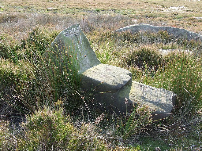
The chair stone. This stone is thought to be natural but is said could have formed a ‘prominent feature’ of the cairnfiled. I should coco!


The smaller stone is almost lost in vegetation. Compare this with Stu’s photo from 2002


I’ll go out on a limb on this one. This is the area of the site marked on the map and at the correct gps ref. I think I’m standing at the northern outer edge of the ring looking south with the inner edge (marked by the change from bilberry to heather) extending and curving rightwards from the nearest fence post to the right hand side of the picture. Just above this the change in vegetation then curves back towards the left (following the line of purple heather)


Looking SSE from the stones of the northern entrance. The white pole is a handy marker for the stones while the track to the site follows the line of the wall that curves to the upper left of picture.

Looking northish from behind the southern outlier, past the southern stones and towards the large stone of the northern entrance.


This is one of two sites close to Skipwith known as Danes Hills. The other is just over a mile and a half away to the southwest. Both are Iron Age square barrow cemeteries.
There are two sites close to Skipwith, both called Danes Hills and both Iron Age square barrow cemeteries. The other site is just over a mile and a half to the northeast.
The two smaller stones are easy enough to spot when approached from the track but the large square boulder on the rise of the hill really draws the eye. If my map reading is correct then the alignment passes northnorthwest just below, and following the line of, Birchen Edge, across the top of Gardom’s Edge, shaves the western edge of Swine Sty and onto White Edge. Whether this alignment was deliberate, part of a field boundary, or just a coincidence and the two small stones formed part of some other structure seems open to question but the alignment theory seems wholly believable on site when standing behind the smaller stones.
This is a bugger to find even with a gps. Approached from the direction of the 4 poster it’s impossible to see this cist until you fall into it as it is beneath the level of the heather, approached from the north however the large boulder becomes evident from a few metres away. This boulder looks like it may be earthfast while the other stones look pretty rough and ready, this is no elegant slab lines tomb but it does have a charm of it’s own, Stu mentions 2 sides of the cist being visible but I could only see the stones of the eastern side, any others must have been buried under the heather.
A lovely little site set on a gentle northeast slope that leads down to Umberley Brook, there’s a real sense of seclusion and isolation about these stones probably enhanced by the trek across the moor to reach them. All three are just over half a metre tall, about a couple of metres apart and with the axis of presumed square being northnortheast – southsouthwest, assuming of course there was ever a fourth stone.
Fairly easy to find and a short walk across the heather from the track that runs along the western edge of the moor. In Stu’s photo from 2002 the area looks to have been recently burnt off and as of summer 2008 the area to the west hasn’t fully regenerated although the stones themselves are starting to become engulfed in heather and rush and the smaller stones that may have formed part of a kerb are already covered.
The suggestion that the natural stone to the west could have been a prominent feature seems very plausible as it sticks out like a sore thumb, looking like some kind of megalithic sun lounger.
Some nice views to the northwest round to the northeast. OS Ref SK28146973
It’s a bit difficult to fathom this one out. There are several sets of 2 or more stones at the grid ref and slightly southwest that could form part of the arc of a ring cairn and the ground is uneven enough to suggest a low bank in places but nothing definite to my eyes. It’s good to read in Idwal’s post that even the archaeologists can’t agree on some of the sites of the moor.
I had a root round for this one but there’s not much to see (assuming that the site is accurately marked on the OS 1:25000 map) There does seem to be a semi-circular feature to the west of the fence that it evident by the growth of heather more than anything else and a slight change in the vegetation to the north and south where the track beside the fence passes through the cairn. Might be worth a look for the bank in winter.
English Heritage seem particularly undecided on the date of this one, saying probably post-Roman through to possibly as late as 7th century but on the other hand maybe Iron Age or even Bronze Age. So could be anything really.
I wonder if there is a clue in where the northeastern end of the earthwork leads to. As I was driving north away from the site I noticed some strange bumps and small hills to the east just after the two roads join and assumed they were quarry spoil heaps. Checking the maps and internet later I found out these are a natural feature known as Canyards Hills and that Natural England calls them “the most impressive example of ‘tumbled ground’ in England and Wales” Is it significant that Bar Dyke leads to, or from these hills?
I wasn’t expecting much from this site but was pleasantly surprised. Set on a gently northeast facing slope framed by Ewden Beck to the north and one of its tributaries to the east English Heritage record this as being a ring cairn rather than a stone circle. It’s difficult to tell exactly what it is as it’s quite overgrown and rooting around in the bracken and heather turns up many half buried small stones that formed part of a bank which the Morgans reckon is about 2-3 metres wide, the whole circle having a diameter of about 20 metres. There are 4 or 5 largish boulders that could be said to be standing together with a few slab like fallen stones, the rest of the larger stones are towards the northern, northeastern and southeastern edges of the ring while those to the west seem to be mainly packing material from the bank. I’m sure there are many more stones that I missed. The northern entrance seems well defined but I couldn’t quite decide which stones formed the southern entrance although what could be a fallen slab outlier could provide a clue.
The site has some decent views from the northwest round to the southeast but it’s the Salter Hills to the east that really draw the eye. There’s also a few interestingly named places close by – Stone Moor, Bolsterstone, Midhopestones and the wonderfully quaint Wigtwizzle.

A simplified version of the plan of the site taken from the information board

Old aerial photo of Mam Tor looking west along Rushup Edge. Windy Knoll in upper left of picture.

July 08. The two most obvious stones of the cist, towards the southwest.