This stone, according to the Somerset Historic Environment record, is a “gritstone pillar 1.5m high, 0.6m wide and 0.4 m thick, which tapers slightly to a flat top”. It had been enjoyed by the local cattle so much that they’d eroded around the base and eventually pushed it over. The local landowners and the National Park Authority re-erected it (it’s now been given a cement base). Originally it had only been 40cm deep, and had some wedged stones as packing. It’s thought to have had prehistoric significance rather than solely be a handy cattle-rubbing post.

Rhiannon
To the south of the farm is a large limestone block nearly 2 metres long, about 1m wide at the base and 30cm wide at the top. This has been provisionally identified as a prehistoric standing stone in the Somerset Historic Environment record. Ever hopeful. As the SHE says, do see if they’ll give you permission at the farm if you want to visit it.
The Somerset Historic Environment record suggests the stone was originally at ST 5653 4562, at the foot of King’s Castle hill. Also that in its new? or long-adopted? guise as Hoker Stone it stood on the green outside Well’s cathedral. Couldn’t people be bothered to walk all that way to seal their bargains? Or was it intentionally brought nearer the cathedral where any dubious goings-on could be quashed? Does anyone know when it was moved?
This sounds like another for the ‘don’t mind me’ category. Thornwell tomb is now “in a recreational green area within a housing estate” according to Coflein, and sprouting trees. When it was investigated – pending the arrival of said estate – it was found to be a Severn-Cotswold style tomb: an oval mound with drystone walling, and three chambers inside (containing bones, pottery and flints).
The Celtic Way website at
celticway.org/gwentborderlands.htm
has an interesting theory that the tomb overlooks a natural crossing point of the Severn. The site says that in the nineteenth century drovers taking cattle to London would swim them across here at low tide. And it’s certainly a natural crossing point today, because one of the Severn Bridges dominates the area:)
.. the abandoned Thornwell farmhouse [is now part of] a dormitory estate.. During the building of the estate in 1990 two burial mounds were discovered, one Neolithic and the other Bronze Age. They are located on the corner of Fountain Way surrounded by a wooden fence. The spot is marked by a large tree.
The location [of the tomb] was reused in the Bronze Age. Two Early Bronze Age cist burials were found close to the main chamber .These contained the remains of two men. Alongside, but unexcavated is a mound classified as a Bronze Age cairn. It is tempting to identify continuity of occupation on what was a strategic crossing of the Severn.
The Long Stone is aptly sited on Longstone Hill, on the boundary of Kilve and East Quantoxhead parishes. It’s said to be 4ft 8ins ‘long’, 17” wide, and 8” thick. Grinsell says it lay recumbent for many years before being reerected by the Friends of Quantock in the 60s. He wasn’t convinced that it was any older than medieval, but another visitor surveying the stone in the 80s mentioned a possible cup mark on the NE side, angling for a Bronze age date.
Somerset Historic Environment Record
webapp1.somerset.gov.uk/her/details.asp?prn=33283
Money Burgh is an oval barrow (rather than a longbarrow) dating from the early to middle Neolithic. It’s positioned on the crest of a chalk spur overlooking the floodplain of the River Ouse, and is still over 2m tall. It’s been a bit damaged – along its top you can see where Mr Joseph Thompson of Deans, a nearby house, decided to open it in the 19th century. One suspects he may not have found the ‘Money’ the burgh promised, but apparently he did find some artifacts of some sort, and a skeleton (probably a later interment) which he gave to Lewes museum. The mound had characteristic banana shaped ditches running along its edges – instead of meeting at the ends they left an 8m causeway.
(Summarised using the SMR on MaGIc)
The two long barrows here are really ‘oval barrows’ – funerary monuments from the Early to Middle Neolithic, and so especially ancient and unusual. They are only 1-2m high now, and in the 1920s it was still possible to see something of the 3m wide ditches that followed their lengths. The scheduled monument record on MaGIc describes these ditches as ‘banana shaped’ – they did not join to encircle the mounds, but were in pairs bent in slightly at both ends. Apparently it is even more unusual that two oval barrows should be found together – underlining the importance of this place/landscape in prehistoric times, especially when you consider the number of other barrows from later periods to be found up here.
Ponter’s Ball is a bit mysterious – it seems people can’t agree on how old it is, or what it was for. But it’s certainly not inconspicuous: it’s a linear earthwork about 15 feet high, and you drive through an (apparently original) gap in it when travelling from Glastonbury to Shepton Mallet. To add to it there’s a ditch on the Shepton Mallet side. As for the name – perhaps someone reading this knows where it derives from?
The Somerset Historical Environment Record adds that both ends of the earthwork are at the 32ft contour- perhaps it was constructed when the water of the sea/marsh was at this height (though it could be longer, with its ends buried by later alluvial deposits). If really does end where it seems to “it can hardly be regarded as a defensive work like the rampart of a hillfort – the area defended is too large, the earthwork too long and would be easily bypassed.” So they suggest it must be seen as territorial boundary (political or for stock protection), or even a religious boundary marking a prehistoric sacred area. The latter being much more romantic of course, but let’s not get too carried away.
Full article at icPerthshire .
Local ‘Earth Energy’ researcher and author David Cowan has some theories about the placing of local stone circles in relation to a major geological fault line.
“According to a local geological map, a fault line runs across Crieff’s High Street, and it may be this which is responsible for some unusual occurrences,” he said. “For instance, one precursor to the Killin ‘quake on the Thursday (20th Jan) afternoon was felt in the Pretoria Bar in the High Street, just prior to the 10pm shock, when a bottle of whisky fell off a shelf. This must have been very unnerving but geological fault lines give a plausible explanation for these seemingly paranormal events.”
David says: “There must be many other ancient sites built upon and making use of the strange but natural energies our planet emits. It is probably this fault, running through a large part of the town which causes people to hear, feel and see things which may frighten them, when the culprit may really be the human brain reacting to natural energies. People may see visions, ghosts and objects but they can be put down to natural sub-surface energies.”
On the Crieff Golf Course there is the remains of an ancient four-stone circle which can be seen from the Crieff-Gilmerton road.
David suggests that the circle has been carefully placed directly on top of a fault line, where the conglomerates – or pudding stones – of the Knock butt against the schistose grits to the south. This fault appears to run down to near Millar Street to the High Street, presumably close to the Pretoria, running roughly parallel to the east of King Street and on to the River Earn bridge.
David explained: “When faults move they emit a wide variety of sounds and electro-magnetic frequencies, rather like an orchestra, with every instrument playing out of tune and at full blast. Any sounds heard are usually deep, like thunder, as the higher frequencies are filtered out by the overlying rock. It is probably these frequencies which caused the bottle to be displaced. Imagine an opera singer smashing a wine glass with a sustained note at a certain pitch, or your washing machine waltzing across the kitchen on full spin. Everything has a resonant frequency, and when it is reached things do start to move, oscillate or break. No ghosts or poltergeists needed to explain this!”
He points out that the siting of this stone circle is not alone – there are a number of ancient sites around Crieff built on top of the many faults which make up the mile-wide Highland Boundary Fracture Zone – the fault which seperates the Highlands from the Scottish Lowlands.
Here are some of the local ancient sites which the Crieff man believes are on volcanic anomalies:
Ochtertyre Mausoleum and burial-ground directly on top of the Highland Boundary Fault;
Monzie Burial-ground and church, surrounded by two faults, the HBF and a nearby parallel fault. The river can be seen tumbling over these faults beside the burial-ground;
A prehistoric cup-marked boulder with some 60 carvings on its surface in a field opposite Foulford Inn in the Sma’ Glen, on a parallel fault to the HBF. Cup-marks are sometimes called petroglyphs. These are depressions, sometimes surrounded by one or more circles pecked into boulders, standing stones and the living rock several thousand years ago;
Another cup-marked stone in field to the east of the Comrie-Cultybraggan road on top of fault leading to Lawers house.
The four-stone circle next to the Comrie graveyard on the low Comrie-Crieff road is also on top of this fault;
Cup-marked stone east side of fault running across the Shaggie Burn, in the Sma’ Glen;
Stone circle (kerbed cairn) in Monzie Castle grounds, again on fault where the Knock conglomerates meet the schistose grits;
Four-stone circle on summit of volcanic pluton to the north of Comrie.
apologies if I’ve linked these to the wrong sites – just let me know, and if you know where any others refer to
Hamish – I found this on the barrow at the Somerset Historic Environment Record:
“The site is named “Big Tree” from an elm which stood on it until c1960. The mound now resembles a [round?] barrow, but the S end may have been removed when the A362 was made.”
Strachey records the barrow as “Modbarow” in his 1737 map, and (spelling obviously not of great importance to him) said “Madborough on Buckland Down is a large round tumulus.. At Madbarrow the Sherriffs Turn* is still kept which shows it a place of remark”. Strachey did not mention any stones (as you’d imagine he would if he’d seen them).
*the Sherrif’s turn, I believe, was like a county court. But outdoors.
Skinner, however, who visited in 1825, was told that three upright stones had once been there. He was also told that burials had been found.
..I have before noticed in my journals that a large tumulus on Buckland Down had three stele or upright stones placed so as to form a triangle; they were, as my informant said, who assisted in breaking the stones for the road[!], as high as a man on horseback, that is about the height of that under our present consideration at Orchardley (Orchardleigh).
(Quote from PSASv67, info also from website link below).
I also read a recentish bit of folklore connected with the site – from Proc Som Arch Soc 87, from 1941. The ‘Big Tree’ was blown down during a severe gale [rather knocking the ‘c1960’ date on the head] “and after a lapse of several years is still lying as it fell untouched.. ‘It has not been removed’ the writer was recently informed, ‘because it is on a burial place’.” We can only speculate whether this was the actual or presumed reason for the tree not being removed.
More on the finds at
webapp1.somerset.gov.uk/her/details.asp?layer=smr&PRN=23165
(Disclaimer: this does include the ‘R’ word, but is in the interests of understanding later views of the barrow.)
The Somerset historic environment record says that the mound lay for a time within a Roman settlement. Roman pottery and a coin were found inside in a 1907 excavation (so the Romans could have dug into it – though the articles might have fallen in from yet another digging episode). The barrow contained the remains of many people – a mixture of bones in the centre (said to be Neolithic) and a number of secondary inhumations with beakers and a flint knife. The mound itself was built mainly of large stones (up to 2.5ft long), with a circular drystone enclosure at the centre.
It kind of raises thoughts about why they chose to settle right next to the barrow. Local ‘Romanised’ families keeping on the good side of local ancestors? Handy for a spring? Didn’t even notice it? I don’t know. But lots of people have used handy barrows as asource of stone – these people apparently didn’t.
This Bronze Age cist is one of only seven to have been documented on Exmoor, only two of which survive. It is lined with slate slabs, and a large 5ft square capstone still partially covers its top. The mound that would have surrounded it was dug into in 1820 for road stone :(
When the cist was disturbed a skeleton was found inside and this was generously (?) reinterred in the churchyard at nearby Treborough.
(info from the scheduled monument record on Magic / Somerset Historic Environment Record).
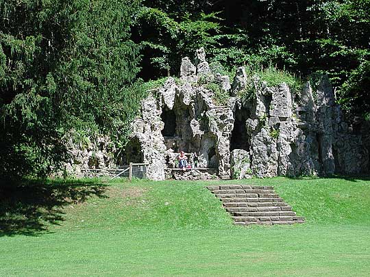
Apparently, at the side of the grotto are some stones moved from a prehistoric site at nearby Tisbury, c1792. (Though according to other accounts, I’ve read, the stones are actually part of the grotto itself.) Josiah Laine, who built the grotto, came from Tisbury, so I guess he was using what he saw to be handy and suitably quaint stones. Supposedly the human remains beneath the stones were placed back under them at their new location. You wouldn’t imagine they’d be best pleased at becoming part of a fashionable garden accessory.
The stones are thought to have come from a neolithic tomb at Place Farm (ST951299) in one of three fields near the junction of the Chicksgrove and Chilmark roads. (wiltshire.gov.uk/community/getcom2.php?id=225)
There is a picture (of the grotto, at least) at the ‘Astoft’ website:
astoft.co.uk/Dscn5986-u2-540-u0.5-q30.jpg
Perhaps that’s one of the stones on the left.
From “The Secret Places Of The Heart” by H. G. Wells (1922).
“Clumsy treasure hunting,” Sir Richmond said. “They bore into Silbury Hill and expect to find a mummified chief or something sensational of that sort, and they don’t, and they report nothing. They haven’t sifted finely enough; they haven’t thought subtly enough. These walls of earth ought to tell what these people ate, what clothes they wore, what woods they used. Was this a sheep land then as it is now, or a cattle land? Were these hills covered by forests? I don’t know. These archaeologists don’t know. Or if they do they haven’t told me, which is just as bad. I don’t believe they know.
...“To-day, among these ancient memories, has taken me out of myself wonderfully. I can’t tell you how good Avebury has been for me. This afternoon half my consciousness has seemed to be a tattooed creature wearing a knife of stone. . . . ”
-online at Arthur’s Classic Novels.
arthursclassicnovels.com/arthurs/wells/spoth10.html
Geophysical surveys of this mysterious oval mound suggest it was originally two Bronze Age round barrows, aligned SE-NW. They’re apparently the nearest barrows to Gorsey Bigbury henge. Curiously the results showed their ditches had little causeways, and the causeways faced each other (imagine a C and a backwards C) – the barrows were only a metre apart. It makes you wonder about the story behind their design and who were buried there.
(info from Jodie Lewis’s article in Proc Univ Brist Spel Soc 2003 vol23)
Two Bronze age round barrows survive in the centre of Wold Newton. They were known locally as the Butt Hills – because they were used in medieval times as archery butts. Medieval ridge and furrow field strips in the area go around where both of the mounds were, confirming them as barrows rather than specially constructed archery mounds. The SMR info on Magic says the barrows survive pretty well despite later career change.
They are near the mere in the centre of the village – a pond fed by the nearby Gypsey Race.
This round barrow is not far from the Rudston monolith and looks down to the north towards the Gypsey Race (well, it could do. But now it’s in a wood). MAGIC scheduled monument info says it is well preserved and stands c 1.5m high, 20m in diameter. It’s apparently quite unusual, the mound being separated from its ditch by a berm – rather like the saucer barrows in Wessex.
Duggleby Howe contained many burials. Ronald Hutton (in ‘Pagan Religions..’) suggests that many of them were sacrifices, there to glorify the burials of just a few important old men. Patriarchy here we come then.
I thought you might like details of his description: it kind of gives a different view of the place. Still mysterious, but not quite as peaceful as Silbury, perhaps. It’s no wonder Fitzcoraldo didn’t get any nice vibes! ;)
In the centre of the mound of packed chalk there was a wooden mortuary hut, and in it a man buried with some flints, a pot, and some red pigment. The mound was built up round this, and as they filled in the shaft above the hut, they included the skull of a youth (with a suspicious looking hole in it). At the top was the skeleton of a child of about three, and to the side the grave of a man of about fifty, buried with arrowheads, knives, ox bones, beavers’ teeth, a bone pin and boar tusks. In the infill of his grave were the bodies of another young child and another youth.
A man of about 70 was placed beside the original shaft, with his head laid as if looking down into its packing. In one hand he had a piece of semitransparent flint, holding it up to his face.
At some time later a man of about 60 was also interred, with again the bodies of a youth and a child above him. He was buried with an axe, an arrowhead and a macehead.
Four piles of mixed bones were found around the graves – bones of oxen, roe deer, foxes, pigs, sheep/goats and humans. Soon after a layer of chalk was piled over everything – over 50 cremations have been found in this layer. A layer of blue clay and more chalk rubble completed the monument. Duggleby Howe probably contains an impressive 5000 tons of material.
The website of the museum where the ‘finds’ are: hullcc.gov.uk/museums/hulleast/index.php
From Nikolaus Pevesner’s ‘Berkshire’ (1966):
.. an estate called Temple Combe and in this the Druidic Temple, called by Horace Walpole ” little master Stonehenge”, a stone circle [sic] found in Jersey in 1785 and brought over as a gift to General Conway in 1787.
The stones were all re-erected accurately, and Walpole is right, as usual, when he calls the monument ” very high-priestly “. [Actually, they probably weren’t that accurate. As he hints below, for a start.]
The circle stood originally on Mont de la Ville, St Helier, Jersey. In its original form the tomb was covered by a mound of earth revetted with drystone walling, but only the megalithic structure was erected in the park. In its present form it consists of a stone-built passage 15 ft long and 5 ft wide roofed with four capstones leading to a circular area enclosed by a ring of thirty upright slabs, against which are built five cells roofed with capstones but open to the centre. The diameter of this circle is now 27 ft, although a contemporary plan made before its removal from Jersey shows it to have been originally 21 ft in diameter. Some slight additions appear to have been made to the monument as a number of the stones are of a sandstone unknown in Jersey but outcropping in Berkshire.
The house and grounds now appear to be owned by this company parkplaceestate.co.uk/index.html
who want to turn it into a country club. The extensive website does not mention their policy on riff-raff wishing to view stones.
I found this extra information in Glyn Daniel’s 1972 ‘Megaliths in History’: the reason why the stones were moved at all was because in 1785 a colonel of the St Helier militia was having a piece of landl levelled for a parade ground (somewhere later occupied by Fort Regent). His men found the ‘Mont de la Ville’ and he offered it to the Governer of Jersey. Apparently the governer didn’t want to pay to have it delivered (he actually was probably thinking, why do I want those stones cluttering up the garden) – so when Horace Walpole persuaded the Marshall to send it to his house near Henley, he agreed. It bears an inscription (or did, at least) – “Cet ancien Temple des Druides decouvert le 12md Aout 1785 sur le Montagne de St Helier dans l’Isle de Jersey, a ete presente par les Habitans a son Excellence le General Conway, leur Gouverneur.” Ah yes, the Druids again.
See it in its original spot at
themodernantiquarian.com/site/7855
Some of the ancient hill-top sites of Southern England are named in this poem by Rudyard Kipling:
“The Run of the Downs”
The Weald is good, the Downs are best -
I’ll give you the run of ‘em, East to West.
Beachy Head and Winddoor Hill,
They were once and they are still.
Firle, Mount Caburn and Mount Harry
Go back as far as sums’ll carry.
Ditchling Beacon and Chanctonbury Ring,
They have looked on many a thing;
And what those two have missed between ‘em
I reckon Truleigh Hill has seen ‘em.
Highden, Bignor and Duncton Down
Knew Old England before the Crown.
Linch Down, Treyford and Sunwood
Knew Old England before the Flood.
And when you end on the Hampshire side -
Butser’s old as Time and Tide.
The Downs are sheep, the Weald is corn,
You be glad you are Sussex born!
From Kiplings ‘Rewards and Fairies’ online at hn.psu.edu/faculty/jmanis/kipling/Rewards-fairies.pdf
Information on ‘Magic.gov.uk’ says that the mound is composed of small stones and is 2.5m high. An early illustration of the barrow in 1911 suggested it had two side chambers. Now there are two large depressions on the southern which could mark their positions.
The norns were the three fates in Norse myth. But one wonders whether this Norn isn’t more local?
This “slightly mutilated” barrow is 1.8m high and about 30m across. An antiquarian excavation found a large flat capstone over a drywalled cist in the centre of the barrow. The cist contained a contracted inhumation, a flint knife and two barbed and tanged arrowheads. Next to the cist was a 0.6m deep pit paved with flat stones; it contained a cremation, two flints and five pieces of bone. Pottery and two small pieces of bronze were also found. No fairies.
Info from the scheduled monument record.
If you’re in the area, you might be interested in following this up, which I saw mentioned in an article on ‘Gloucestershire Barrows’ in the 1989 volume of the Trans Brist Glouc Arch Soc...
Just ‘round the corner’ from the Hoar Stone was the Jack Barrow – at SO957071, judging by its position on the map at old-maps.co.uk – on the land of Jackbarrow farm, in fact.
The barrow was destroyed/excavated in Victorian times – but the excavators “considerately” took the bones and reinterred them at the church in nearby Duntisbourne Abbots (at SO971078), popping a nice stone cross on top. I suppose their hearts were in the right place.
Cynthia Haddon has a picture on her standing stones page at
celiahaddon.co.uk/standing%20stones/gloucestershire.html
The engraving reads:
“These Rough stones taken
from the barrow,
Jack Barrow farm,
Cover the human
remains found therein
when it was opened 1875”.
I have not looked it up but more info should be available in an article in TBGAS vol 59 (1937) 334-337.
This site sounds rather interesting but I can hardly find any information on it – perhaps someone local can provide enlightenment. (The combination of barrow and spring attracted me – but of course may be totally coincidental).
Blood Hill is a round barrow only about a mile from Grimes Graves, on a path through Thetford Forest. It has a tantalising name – behind which there must surely be a good story? Some kind of prehistoric boundary bank is also associated with the mound.
A stone’s throw downhill is the holy well of St Helen (once contracted to ‘Tenant’s Well’ according to the smr) and the remains of her church (St Helen’s Oratory). The parish boundary (and the railway) run close by. A long distance footpath passes the site, so it should be quite accessible.
The water from the spring runs into the Little Ouse – if you look on the map there are a couple of other barrows nearby along this stretch of the river valley too.
This is an interesting letter from Richard Fenton, a lawyer and author who became friends with Colt-Hoare after meeting him at Stourhead House, as he recounts below. It gives rather an insight into the way barrows were excavated at the time.
Stourton, November 14, 1807.
MY DEAR CHARLES,
Here we still are, notwithstanding the unpleasantness of the season, fascinated by the superior charms of this lovely place, where the absence of summer is so happily supplied by groves of evergreens, that winter cannot be felt.
Yesterday we partook of a treat, such as I had never been a guest at before. Hearing that it was in contemplation to open an immense tumulus with the popular name of Jack’s Castle, in the vicinity of that memorable spot where Alfred’s Tower rises, which had been always considered to have been a beacon, and probably might have been made use of for that purpose several hundred years after its first erection; I signified to the landlord, that if he thought there would be no impropriety in it, I should be happy to be present at this ceremony. He said he was well assured that nothing could be more gratifying to Sir Richard Hoare than the presence of any gentleman actuated by such curiosity; adding, that he would, with our permission, as it were from himself, get our wishes made known. This produced a most polite invitation from the Baronet, and we hastened to obey the summons.
The men employed to open those primitive sepulchres, and who by almost, constant experience are deeply skilled in the operation, had been sent early in the morning to prepare the work, which by twelve o’clock, when the company assembled, was in such a state of forwardness as to render every stroke of the pick-axe, and every motion of the shovel, highly critical and interesting, charcoal being perceived, the never failing criterion of its having been sepulchral. On this symptom the gentleman who presided at this business, and under whose eye the solemn process was graduated, descended into the opening that had been made, and by some minute, and to us mystic observations, feeling as it were the pulse of the barrow, was justified in pronouncing that “the consummation devoutly to be wished” was at hand; for no sooner had he pronounced this, than the cyst or factitious cavity, in which, instead of an urn, the ashes of the dead were deposited, was discovered, among which was found a stone hatchet, with a red blotch over part of it, as if it had been stained with blood, grown after a lapse of ages to look like red paint, time not having the power to efface it: this little weapon was highly finished. There was likewise a piece of a spear’s head, of brass or mixed metal, the produce of countries more civilized, the effect of barter, for it hardly can be supposed that a people who had the means of fabricating such a weapon of metal would submit to the slow and tiresome process of resorting to stone and flint.
Extracted from Richard Fenton’s ‘A Barrister’s Tour through Somerset . . .’ and taken from Richard Soar’s ‘Barn Elms’ website at
barnelms.com/
(Without the trees would this site have been intervisible with White Sheet Hill? Read petroglyph sid’s remarks on the link – Alfred’s Tower is very close to the barrow)
John Strachey noted in 1737:
“Years ago viz about 1724 or 1725, taking away several loads to mend ye highway the workmen discovered the bones of a large man by several smaller skulls, lying in a sort of chest having two great rude stones at head and feet, two side stones and a coverer. Some say a great number of bones. The barrow is overall, has a pit or hollow in ye top..“At ye east end are now remaining 2 upright stones about 3ft [or 8ft?] high which if opened might probably discover such another chest of skeletons..”
‘Murtry Hill’ could be a version of ‘Mortuary Hill’. The area belonged to monks at Henton, and a document mentions the tithes of ‘Mortuary’s Field’. (this is mentioned in PSASv57 – 1911).
for references see the Somerset Historic Envt Record at
webapp1.somerset.gov.uk/her/details.asp?prn=23161
Perhaps there were once quite a few long barrows in this area – there was definitely the one at Fromefield, and there may have been one here ‘opposite’ Murtry Hill – on the hill suspiciously named ‘Barrow Hill’.
In 1825 B M Skinner wrote of the latter: “a vaulted tumulus similar to that at Stoney Littleton, which has been nearly destroyed for the sake of procuring materials for the roads, and where quantities of human bones were found.”
An earlier commentator, Strachey, refers to the barrow in 1737: “..here is a stone 8ft long and 2ft square now lying down but probably upright formerly..“.
Anglo-Saxon burials were found in the same kind of area in the 1920s, but if anything wouldn’t it be that they were reusing an older burial site – the Anglo-Saxons didn’t go in for ‘stone vaulted tumuli’?
Info gleaned from the Somerset Historic Environment Record at webapp1.somerset.gov.uk/her/sop.asp?flash=true
Markings on the ground here (just south-east of Silbury Hill) were spotted in an aerial photograph in the 1950s. It was some time later in the 1970s that they were first investigated, when a trench for a pipe was being dug.
The then Avebury museum curator Faith Vatcher found traces of large holes which would have held 50cm diameter wooden posts – these perhaps would have been a massive 8m tall*. These outlined the larger westerly enclosure (350m long, 200 across). The other enclosure was rounder, and had slightly smaller posts (five for every 3 metres).
The map on the link shows the layout of what is known – the complex of double rings, curves and straight lengths, with maybe smaller rings to the south east. Although the stream cuts through it, it’s possible that this has changed since the late Neolithic when the enclosures were probably constructed.
Alasdair Whittle excavated the enclosures between 1987 and 1992. If you can find it, his 1997 report “Sacred mound, holy rings” should give the full story.
also see the record at Magic
magic.gov.uk/rsm/10380.pdf
for more facts and figures.
*mentioned in Pitts’ ‘Hengeworld‘
Marden not only had its huge banks and the Hatfield Barrow – it had another mysterious mound. You can see where it was on the picture of the map above (quaintly marked ‘site of tumulus’). William Cunnington described the 60m diameter feature in 1807 (he was Colt Hoare’s foreman and chief Hatfield Barrow Ruiner):
“Its vallum [bank] is slightly raised and the interior rises gradually to a low apex. On digging within the area we found a few bits of old pottery, and a little charred wood but no marks of any interment.”
Sixty metres is pretty big – only a little smaller than the size of Woodhenge. Mike Pitts (in Hengeworld) hints that the feature could have been a Woodhenge-style enclosure with posts, rather than a barrow.. but of course (in line with the general lack of investigation at Marden?) the spot has never been archaeologically examined...
Mike Pitts mentions the following in his ‘Hengeworld’ book:
In 1769, John Mayo (local vicar) wrote a letter to the Society of Antiquaries in London. A farmer had levelled part of the bank surrounding Marden the previous year and had found a human skeleton, which Mayo reckoned to have been a person “about 6ft 2 or 3 inches high.”
Interestingly, he also noted that “a great many Staggs Horns were digged up.” – of course, antlers have been found at many other neolithic sites (Avebury for example), having been used to dig out the giant ditches.
Stukeley believed that there’d been an avenue on the west side of Avebury – he recorded two remaining (now removed) stones of it where it joined the main circle, opposite the churchyard. He also noted many other boulders and suspicious looking depressions in the ground. He said it had crossed the Winterbourne stream (some stones subsequently being incorporated into the bridge), through where a row of houses were present on the south side of Bray Street, and headed out into “open plow’d fields” to join the Longstones. Stukeley imagined there would be a temple rather like the Sanctuary at its end, but he found nothing. Still, for those who would like to dream, he did predict the avenue, and as we know for many many years this was held to be a silly idea...
(unfortunately gleaned from Pitts’ ‘Hengeworld’ and not Stukeley’s own writings)
Stukeley was convinced that the avenue continued beyond Longstones Field to the south-west, eventually terminating on a low hill at Fox Covert (’a most solemn and awful place’). However, the archaeologists from Southampton aren’t convinced, and believe the avenue actually ended in Longstones Field, at or just beyond the cove, though ‘ambiguities remain’. Which is still an impressive 4km to the Sanctuary.
Arminghall is one of those sites that looks like nothing today, but in its time would undoubtedly have been pretty astonishing.
Like Woodhenge, its potential was spotted from the air by brave military pilot Gilbert Insall, who snapped it with his camera. Grahame Clark excavated it in 1935 – he found eight enormous post holes in the middle of the henge. Each was equipped with a slope to help manoeuvring (you can see these in the diagram posted by KK), and they were arranged in a horseshoe, with the open part next to the henge entrance.
The two holes that Clark excavated most thoroughly had post pipes nearly 1m across. Post pipes are the traces in the soil of rotted timber posts – so the oak timber posts must have been Enormous.
Considering Maud Cunnington thought her 85cm postpipes at Woodhenge translated into posts rising 7.5m above the ground and weighing 5 1/2 tons – well, Arminghall must surely have been a stupendous sight.
Though this may take some imagining considering its current environment.
(gleaned from Mike Pitts’ ‘Hengeworld’)
Stonehenge, Woodhenge,... but what about Coneybury Henge? (sacred to rabbits?) It’s less than a mile from Stonehenge itself. Ok, so it never had big stones with fancy lintels. But it sounds intriguing.
Julian Richards excavated the site on Coneybury Hill in 1980. I’m afraid it’s been ploughed so flat you wouldn’t be able to tell where it is without one of those geophysics machines. But if you’re driving up the A303 and reach the band of trees with the New King Barrows – well, it was into the next field to the south of the road there and was probably intervisible with whatever was going on at (the probably contemporary) early Stonehenge.
Richards found a c50m diameter ditch, which would have been a not inconsiderable 10ft deep, and which would have been surrounded by a bank. There was an entrance at the NE side, as the entrance is at Stonehenge.
A ring of small post holes circled the inside area(possibly 56, the same number as the Aubrey holes at Stonehenge) – and weirdest, within the circle were tiny holes which were the result of hundreds of little pointy-bottomed stakes being pushed into the ground.
(info mentioned in Pitts’ ‘Hengeworld’)
If you look on the map the site is not so very far from the end of the avenue, where it apparently met the river. Though whether you could actually see it, or whether there’s any relevance to that I know not.
I was intrigued to see the “Millbarrow” marked on a map in the papery TMA. Some searching revealed it had been a longbarrow north-east of Windmill Hill at SU094722, but was apparently destroyed by an uncaring farmer in 1863.
Aubrey drew it in his Monumenta Britannica. It was surrounded by stones – he called it ‘an orthostatic peristalith’ to be technical.
Stukeley also drew it in 1743, calling it ‘a most magnificent sepulchre’.
The barrow was just west of Winterbourne Monkton, and if you go to that village’s church you will see that the Reverend Brinsden’s grave is marked by a sarsen from the barrow – supposedly the capstone of the barrow’s chamber.
The site of the barrow was excavated in 1994, and the results are in volume 87 of the Wiltshire Archaeological and Natural History Society Magazine.
I do think the reuse of sites is interesting. Iron Age people built the huge fort up here for defence, and in World War 2 the US Air Force appropriated the site for their anti-aircraft guns – so, it was still being used for defence millennia later.
Just so as you know if you visit – these were apparently where the hollows are around the edge of the fort interior. Possibly more interesting (but invisible) would be the traces of 40 hut circles found using geophysics inside the castle in 1996.
(WANHM excavation notes, vol93)
Thoughts on Silbury’s innards:
An account from ‘An Illustration of Stonehenge and Abury’ by Henry Browne, 1823 (in Wilts Arch & Nat Hist Mag v95, 2002). It’s an eyewitness account of the 1776 dig.
“... This elderly gentleman [a Mr Hickley from Avebury] when a youth, was at Silbury Hill on the occasion of some miners sinking a large hole or well down the centre of it to the ground on which it began to be raised. In doing this they found a piece of timber continued down the whole way, evidently for a centre from whence to take the measurement of the hill in working it upwards.”
It was nearly 50 years after the event, so although you might expect some elaboration / misremembering – surely this isn’t an obvious yarn to tell? Wouldn’t you be more likely to come up with the old ‘skeleton / treasure’ option rather than a central timber?
Another contemporaryish account is interesting: James Douglas, in his 1793 ‘Nenia Britannica’ recorded that the Duke of Northumberland’s foreman of the work (a Colonal Drax) “had a fancy that this hill had been raised over a Druid oak, and he thought the remains of it were discovered in the excavation.”
And indeed, Richard Atkinson, leader of the 1960s BBCized dig thought that the 1776 shaft would probably have destroyed any central deposit at the base of the mound, and no doubt anything vertical in the core...
Phill Quinn’s ‘Holy Wells of the Bath and Bristol Region’ mentions a spring below Black Down. It was / is? at ST484580, in a field called ‘Hawkeswell Quoit’ – so presumably it was the Hawkeswell. But what’s this ‘quoit’? Isn’t that (bar referring to the game) a word for a standing stone? As Quinn says, it would be interesting if there was once a stone associated with the spring. Though perhaps we have got the wrong end of the stick in the pursuit of a good story.
According to Ruth E St Leger-Gordon, the author and playwright Eden Philpotts wrote this poem about the stones. Philpotts thinks there are only seven. Why is counting stones so difficult, even without poetic license?
And now at every Hunter’s Moon
That haggard cirque of stones so still
Awakens to immortal thrill
And seven small maidens in silver shoon
Twixt dark of night and white of day
Twinkle upon the sere old heath
Like living blossoms in a wreath
Then shrink again to granite grey.
So blue-eyed Dian shall ever dance
With Linnette, Bethkin, Jennifer,
Arisa, Petronell and Nance.
Although Philpotts describes them dancing, St L-G favours the idea that if you visit at noon you might see them all just shift their positions very slightly. Don’t blink.
Dyer, in his ‘Southern Britain’ (drawing on info from the Bedfordshire Magazine 8) describes the opening of two of the bell barrows in August 1850. The event drew a crowd: “a large assembly of persons of the middle and working classes who exhibited much interest in the progress of the works.” Their conduct “was extremely orderly” you’ll be pleased to hear. Personally I can’t stand it when the hoipolloi get rowdy at one’s archaeological dig. Mind you, the excitement was for nothing; nothing (ie no treasure) was found.
When the early 19th century inhabitants of Fromefield House decided they wanted their garden extending, they had to level a barrow that was inconsiderately in their way. The process wasn’t well recorded but apparently five skeletons were discovered amongst limestone slabs (which were no doubt once the chambers of the barrow). Excavations in the 1960s found traces of up to 15 people interred at the site. Sherds of Neolithic pottery were also found – these are apparently now in Taunton Museum. The area has now been built on: the site of the barrow is now located under 14 Leystone Close.
The longbarrow might have been destroyed but you can still see some of the stones – or can you? At one point, one of the larger stones was put upright – about 6 foot tall, and was under a beech tree by the drive leading to Leystones. Two other stones were in the garden of ‘Stonelands’ (5ft and 2ft) and one 6ft long in the garden of ‘Ormonde’. ST781489.
More details in the Frome Archaeological Assessment by Clare Gathercole, at somerset.gov.uk/somerset/media//1B209/EUS_FromeText.pdf
and the Somerset Historic Environment Record
webapp1.somerset.gov.uk/her/details.asp?prn=23537
[maybe this really suggests there’s nothing to see. It’s a bit confusing].
On the map at the SHER they appear to be somewhere on the right hand side of Leystones Close. Also in the (back?) garden of number 21.
Carn Brea was long presumed to be an Iron Age hillfort, but discoveries proved it to have been originally fortified in the early Neolithic. And things weren’t as peaceful in the Neolithic as one might imagine. In 3800BC the occupants raised a massive stone wall to defend the settlement. It seems like they needed it: in 3500BC they were furiously attacked (as evidenced by all the arrowheads found) and the village was destroyed by fire.
(Roger Mercer’s research described by Ronald Hutton in ‘Pagan Religions of the Ancient British Isles’ 1991)
Ocifant may not have been very impressed with the long barrows at Hazleton, but did he realise they feature in ‘Raiders of the Lost Ark’? Surely that would have changed his mind. Well, perhaps not.
In the film Harrison Ford gives a lecture to his archaeology class about ‘Turkdean barrow near Hazleton’. He says “This site demonstrates one of the great dangers of archaeology.. not of life and limb although that does sometimes take place.. No, I’m talking about folklore. In this case a local tradition held that there was a golden coffin buried at the site... this accounts for the holes dug all over the barrow...”
I’ve no idea if this common folklore motif really is attached to this barrow (a golden coffin is supposed to be at Windmill Tump, near a (different) Hazleton Manor). Lots of barrows have the folklore that they contain a golden object (though it’s very rare that any actually do) so it’s not surprising the film makers should mention this theme – all three films are about myth and archaeology are they not?
Perhaps the film makers chose Hazleton because the north barrow there was very comprehensively excavated – I suppose it must be a well known example of a Cotswold-Severn style barrow amongst archaeologists. The films all have some loose! basis in ‘real’ legendary subjects. But I don’t think it was excavated until the 1980s! so Dr Jones in his 1930s university wouldn’t have heard of it.
Perhaps you could visit the Corinium Museum in Cirencester, where they have reconstructed the chambers, if you want to know what was found.
british-publishing.com/Pages/CirencesterOG/TheCoMuseum.htm
Personally I’m quite frightened that my current interest might be simply traced subconsciously to a childhood obsession with a film.
The ‘Five Springs’ originate at the NW corner of the site, then the stream flows south along the western boundary of the enclosure. This was originally all marshy, but it was drained when the railway line was constructed in the 19th century (I wonder, can you see anything of the site from the train?). According to the EH record on MAGIC, Waulud’s Bank is truly a unique type of monument – but it draws comparisons with the ‘henge enclosures’, Marden particularly, as a stream too forms part of its boundary. They’re not the same though, as Waulud’s ditch (some 15-20m across) is on the outside, whereas Marden et al.’s are on the inside. And another possible difference is that Waulud’s Bank has no opposing hengey-type entrances – but maybe the evidence for those just hasn’t been found yet. The site has rarely been ploughed and under all the modern muck there’s probably all sorts of clues waiting to be found – maybe especially in the boggy bits where organic material can survive.
Also, although you might be horrified by the amount of 21st century detritus round here, it seems it’s hardly a new issue. The ditch on the northern side of the site was enlarged in the Roman period, at which time a lot of 2nd century junk got dumped into it (as mentioned in Dyer’s ‘Southern Britain’).
Not the more famous Blowing Stone at Uffington, but another similarly holey sarsen. According to Katy Jordan (in ‘The Haunted Landscape’) this one lies near the Crown Inn in Aldbourne, on the pavement east of the village pond. It has a small deep hole at one end. Apparently it was ‘powerful enough to really get on villagers’ nerves when small boys repeatedly sounded the stone’. I was interested to read that the local blacksmith was hired (at some unspecified time) to plug the hole (a perfectly reasonable request, but it brought to my mind the mythological aspects of the blacksmith). Although the plug was (allegedly) later removed the stone is now silent. When KJ asked about it at the pub, no one seemed to know anything about it (her information originally came from a 1975 book by local author Ida Gandy).
The Tump was also known as ‘Swanborough Ash’ because three ash trees grew on it (the name is in a document from 1764). Katy Jordan records in her ‘Haunted Landscape’ book that during the 1970s when she lived in the Pewsey Vale, the Swanborough ‘Team of Parishes’ used a picture of the tump as their emblem – it was the mound and the legendary three ash trees (there were a few more than three trees there when I visited:). It’s interesting that the site is now being used as a Christian symbol: the three trees on the mound are likened to the three crosses on the mound of Golgotha. Just part of the continued evolution of the site’s meaning to local people, I suppose.
A little more information, from Dyer’s ‘Southern England’:
He mentions the ‘H’ formation of the three lower stones, suggesting “on the analogy of the other Kentish megaliths we may assume that stones also stood at either side of the monument thus forming two small enclosed chambers.” Small? Very small more like. And what do people think of the chunk missing from the stone in the middle? Could it not be that the middle stone is the ‘doorway’ to a chamber behind, and the chunk missing the bit you must squeeze through (rather like the portals present at some other sites?). Just a thought.
Aerial photos show the stones were once part of a longbarrow 80m long and 12-15m wide (details on MAGIC) and lying east to west. It’s only relatively recently (the 1940s) that stones were still being removed from the site.
Stukeley recorded an arc of small stones lying on either side of the chamber, apparently indicating a facade. There were stones around the perimeter of the barrow too, so the mound may have been revetted. One of Stukeley’s sketches shows a single large stone at the far end of the original mound. It was known as ‘The General’s Tomb’. Unfortunately it was destroyed in 1867. It’s possible that some other stones still exist under the soil somewhere though.
Julliberrie’s Grave was thoughtfully sited on the false crest of the Down, overlooking the River Stour below. According to the smr on MAGIC, this longbarrow was once even longer: 60m maybe, instead of 45 as it is now. Perhaps that explains the lack of a burial chamber – it was in the NNW end that was quarried away.
Dyer (in ‘Southern Britain’) describes how the barrow was reused over the centuries: there were Romano-British burials found in the south ditch, which were covered with cairns of flints. So maybe there is a roman general inside – who knows.
A damaged late Neolithic axehead was found in the turf core of the longbarrow when it was excavated in the 1930s.
Lots on the history of the excavations at the Wikipedia
en.wikipedia.org/wiki/Julliberrie’s_Grave
James Dyer (in ‘Southern England: an archaeological guide’) suggests the stone resembles a horse. Methinks he has a good imagination, but perhaps I’m missing the point.
He says that not only are there fragments of stone in the vicinity, which suggest the stone was part of a tomb, but (drawing on ‘South East England’ by R Jessup) that another burial chamber used to be nearby too.
It was “similar to the Chestnuts and Coldrum, and was discovered by a ploughman at the other end of the same field in 1823. It seems to have consisted of a tomb 2.1m long, with three wall stones, and to have contained human bones and pottery. Known as Smythe’s megalith, after the antiquary who best recorded it, it has since been destroyed.”
South Street longbarrow is only 70m south east of the Long Stones standing stones and 300m north east of the Beckhampton long barrow. I say ‘is’ – you can just about still see it, allegedly. If it’s any help in locating it, South Street (now Nash Road) grazes its south-easterly end (it’s aligned WNW to ESE). A partial excavation in the 1960s discovered how the mound had been created: hurdle fences were arranged to form forty bays into which chalk rubble from the two flanking ditches was tipped. Flint arrowheads, animal bones and fragments of pottery were found, but no burials (like the very close and similarly old Beckhampton barrow). Ploughing marks were found beneath the barrow – a rare find.
King’s Play Hill is prominent in the landscape – part of the striking undulating hills that rise out of the flat land below. The slope is steepest to the north-west, but the longbarrow here is sited just below the crest on the south-east side. This gives it extensive views over the Vale of Pewsey (rather than the view of the flat Neolithic desert south-east of Chippenham, which it could otherwise enjoy). The mound only stands 1m high now, and is orientated in the popular NE-SW direction. Cunnington dug into it in the 19th century to disturb a crouched skeleton and a number of flint flakes.
There are also two later bowl barrows on the hill’s crest – these would probably be visible from a wider variety of directions therefore? According to the Victoria County History, one of these was reused for a burial in Saxon times (though this is not mentioned in the EH SMR).