As Broen says try and make time to see the hut circles. It’s a good starting place to walk up to the Caer y Tawr hillfort.
The site is well signposted from the road to the South Stack. There are around 20 ‘huts’ left to be seen at the foot of Holyhead Mountain dating back to the Iron Age.
Some of the huts look to have stone benches and bowls.
stubob


The view from the stones to Holyhead Mountain is amazing, it would be worth the journey just for that alone. Add to that a pair of great looking thin stones and it’s easy to spend hours up there.

The fence has now thankfully gone.
Only the Aluminium Plant to go......
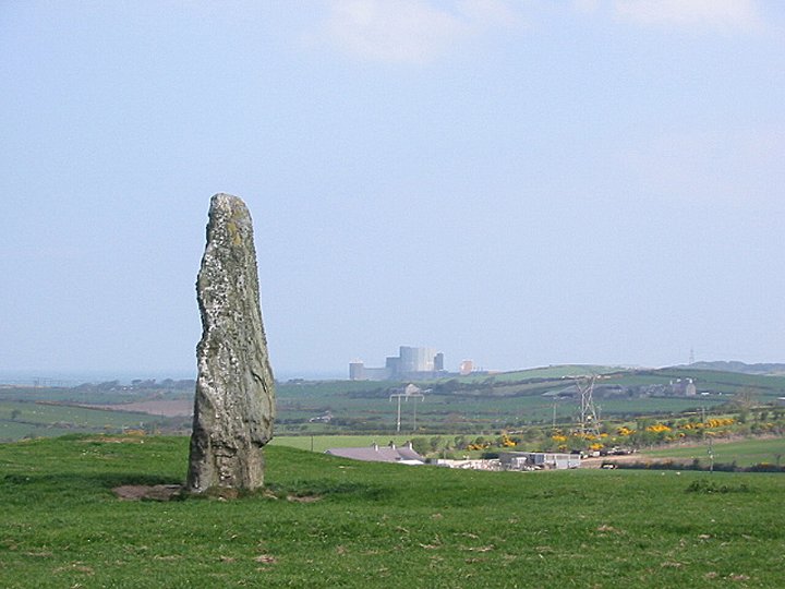
You can see this stone from a fair distance, easily 10ft tall and in my opinion one of Anglesey’s best.

No trip to Anglesey seems complete without paying the stones at Pen-yr-Orsedd a visit.
This one is easily seen from the road, and is very tall and wafer thin. With one side often covered in cowshit, and farm machinery laying around it.


‘Viewed over a wall’? Get yourself over the gate IronMan. Then again I was there at 6.30am so everything was quiet.......
The chamber’s a funny old jumble of stones, now inhabited by lambs.

Easy access over a stile at the end of a cul-de-sac in Llanfechell.
Pity about the pylons and overhead lines but they take nowt away from this great stone.
It’s only a short walk up from the road at the SW end of the LLyn Alaw reservoir to the standing stone at Bod Deiniol.
A big stone over 6ft high and getting on for 6ft across.
Holy Island Mountain is visible on the horizon in the West(ish)

This great looking stone was sporting a rather naff pentagram, carved on it’s road side face.
I saw the same looking carving on one of the stones at Mein Hirion. They both looked to be carved into the lichen rather than the stone. It’s still bollocks tho’.....

This a great place to watch the sun go down. I’ve been here before in the daytime. But the place takes on a different atmosphere in the evening with the stones turning all shades of orange.


A bit tricky to find even though it’s in Brynsiencyn itself and it ain’t that bigga place it has to be said.
Although the chambers ruined now, the capstone is still impressive and rests on two stones, I wouldn’t know if the stones have fallen or were just squat anyway.


Armed with machetes this time to cut through the rhodadendruns, we came across a tunnnel already cut through them, hands and knees stuff for about 50yds through the thick branches.....at the end of the tunnel there stands the Turning Stone. Sadly no longer rocking....looking at it I don’t see how it ever did....but it’s still a great looking lump of rock.
The ‘tunnels’ go all the way along Overton Tor, sometimes only a few inches from the edge....and it’s along way down. But there was no sign of Robin Hoods Mark.
.............................................................................
Over the last few years I’ve recovered a handful of waste flint flakes in the fields close to Cocking Tor.
This is the largest of the four cat stones that lie along the Eastern edge of the moor, so it kinda carries the ‘Cat Stone’ label.
Cat is derived from Cath, meaning battle. All four stones carry dates and some have coronets.
Along with the Cat Stone pictured, inscribed ‘E.I.N 1831’, the other easy stone to spot is the Duke of York stone, a hundred yards or so NE of Stanton Moor North.
Sharp Low hasn’t survived as well as some of the other barrows around Tissington, and now it’s becoming a bit of a builders yard with piles of walling stone laying around.
It’s a good vantage point to see the other barrows in the area tho’ with Moat Low,Boars Low and Gorsey Low easy to spot.
Right next to a path that runs from Gag Lane Barn SK158531

A decent enough bowl barrow, the Beech trees that grow on the barrow making its location very easy to spot from quite a distance.
Access is easy enough along a path from Moatlow Farm, room to squeeze a car off the road near the path and farm.

In the first edition of the one-inch O.S Maps for Sheffield and Chesterfield. The Glory Stones SK213853 are marked as ‘Rocking Stones’.

04/03. A hut circle can just about be made out in the grass. Stanage Edge behind. (Sheepwash Bank).
J.Barnatt suggested in his 1990 book that these two sites were possibly robbed/ring cairns. Although it is now thought the circular rubble rings are probably hut circles. The rest of the features suggest the area was used in the Bronze Age for settlement and agriculture.
Clearance cairns and linear field walls are also quite visible, amongst the tufty grass. Especially on the Sheepwash Bank site.
The sites lay next to each other on two spurs of land below Stanage Edge.
(Dennis SK228840 & Sheepwash SK230841)

04/03. Bit of a magic eye picture. Swastika carving and a double ring above it.
Stoney Low is now just a large oval rim, after being robbed for stone in the 19th century.
There are still a few large stones that were possibly something to do with chambers/cists, inside the rim.
In the 19th century Bateman saw a cist as the stone was being robbed, but no plans were made of the mound.
The reason to see Stoney Low now is because of it’s location.... looking West there are two rocky limestone ridges. Framed between them is Minninglow.
Stoney Low gives the best view of the Rockhurst long barrow. On the left knoll the barrow appears as 2 small round barrows.
Another sad aspect of Stoney Low is.... is the disappearance of two stone circles that one stood to the East of the mound. One 39ft across with stones of arond 2 ft tall. A few feet from this was a smaller circle.


04/03. One of the larger remaining stones at Stoney Low. Has the look of a portal stone about it.
Minninglow on the horizon.

Galley Low is in great shape and still a good height, not the usual ploughed Derbyshire barrow you come to expect; especially with it being located in farmland
Bateman made 3 visits here between 1843-44, near the head of a skeleton he found a food vessel and bone dagger.
The barrow is well known because of the grave goods Bateman unearthed. Amongst them was a finely crafted necklace of gold. The necklace was part of a secondary burial that took place the 7th Century.
Last dug in the 1950’s.. so thinking about.. it is in surprisingly good shape, compared to most of the barrows surrounding the hill of Minninglow.
Harthill Moor is a great area, with a handful of sites all within a few minutes walk of each other.
From the Neolithic(?) Cratcliff hillfort, the ancient Portway track, Bronze Age stone circle and barrows, Iron Age rings and settlements through to the Medieval hermits cave and finally the farm that’s there now.
Thousands of years worth of settlement all within view of Robin Hood’s Stride.


04/03. 2 remaining uprights. The shape of the circle can be made out. Fallen stone at bottom.

04/03. Looking across Ladybower. The circle is at the foot of the flat topped crag on Crook Hill.
I’d never come across this circle in any books, so it was a surprise to see it on the NMR.
This small circle is located between the 2 rocky crags on Crook Hill. Of the 5 stones that make up the circle, only 2 remain standing ( both around 50cm tall ) the fallen ones are becoming overgrown with grass. Small patches of rubble may mean the circle was a kerb cairn.
Not far from Moscar Moor another small monument with a ring of 5 stones around a surviving mound.
Storming views with White Tor and the Salt Cellar in the East, Win Hill and Bamford Edge in the South and the crags of Crook Hill in the West.
Parking at Rough Wood car park, head back to the reservoir at the junction turn left and look for the path marked ‘Crook Hill Farm’. When you hit the open moorland just outside the farm, head NW(ish) off the path. The 2 standing stones are easy to spot.
Excellent.
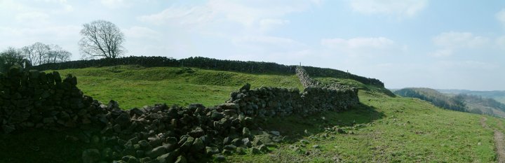
Thought to date from the Iron Age. A roughly circular enclosure, a 5m wide rock cut ditch surrounds the site. Natural outcrops of stone are used in the construction as additional boundaries.
Building platforms have been identified within the enclosure.
A better view of the ‘enclosure’ can be seen from Robin Hood’s Stride.

03/02. The ‘enclosure’ as seen from Robin Hood’s Stride.