
A bit of a strange one. The smaller stones that could be part of a circle are mainly buried in clumps of heather, but they could form a circle....I guess.
J.Barnatt has the circle down to a fortuitous arrangement of stones.
Sadly the rocking stone marked on the late 1800’s O.S maps is no longer rocking. A familiar tale in Derbyshire.
----------------------------------------------------------------------------
09/05.
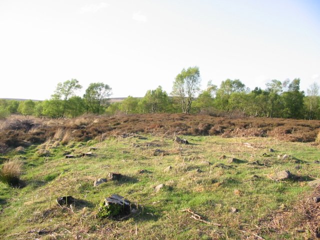
I had a feeling for sometime that the stone features mentioned by Flopsypete to the south of the circle were associated with a medieval farm/settlement.
Remembering to check them out last time I was up there.....I’m pretty certain that they relate this settlement. The structures, marked in places by upright stones, are in fact the remains of a long house, a smaller building and an enclosure wall.
Not prehistoric but an interesting spot all the same.
There are similar but more ruinous structures over the road in the Sheffield Plantation on the Longshaw Estate.
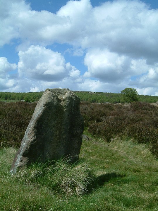


05/03. The Chair Stone. This is the area of the now destroyed Neolithic cairn, possible traces of a rim can be seen near to the trig point.

Harboro’ Rocks are an impressive outcrop of dolomitic limestone.
At the top of the rocks between the trig point and the rock ‘chair’ there used to be a chambered cairn, now sadly destroyed. Altho’ inspecting the ground shows what maybe traces of a rim. The cairn was thought to date to the Neolithic, and several crouched skeletons were found in the chamber.
In the early Iron age the site was used, and some bumps in the terraces on the eastern side are thought to be housing platforms.
Access is easy, there’s room to park near the Hopton Works.
The views from the top have got to be seen, and there’s a few strange shaped natural menhirs dotted around the place. And caves to explore on the lower terraces.
Top place.

05/03. These marks are to the left of the serpent carvings on the same rock. Are they part of another worn carving?
In the book ‘Place Names of the Peak District’ the King Stone is referred to as being a flautist and not a fiddler, who was turned to stone for playing on the sabbath.
The Peak District is named not after the hills but after the tribe “Pecsaetans” who lived in the area, the name roughly means ‘Hill dwellers’.
The fort at Fin Cop is an easy walk from the Monsal Dale Hotel, with some excellent views of Monsal Dale below on the trek out.
The fort is defended to the South and East by banks and ditches and to the North and West by the steep sides of Monsal Dale. At the Eastern side, the side you approach from, double banks and ditches are still impressive, an entrance is central to this part of the defences, which carry on over the wall in the form of a single bank.
The views from the top are unreal with Five Wells in the West, Kinder Scout just visible in the North and Beeley Moor quite close in the South-East(ish).
Monsal is one of the best places to watch a Derbyshire sunset without doubt.
An added attraction this time of the year are the banks of the fort covered in Mountain Pansies and ‘Early Purple’ Orchids.

05/03. The front of the bank is sorta in the foreground along the line of the tuft of spiky grass. The grass on left of pic is inside the ring cairn.
‘No wait it gets better’. The cairn on the NE corner, that kinda gives the ring cairns location away. .....Is right behind the tuft o’ spiky grass.

As in Holy’s misc. post, the site has been sometimes referred to as a stone circle......I wonder if this is down to the 1:6250 O.S map where it’s marked as a “circle of stones”.
The cairn has recently been cleared of the Silver Birch that were growing on it’s banks. Apart from some compass work, the stacks of logs are among one of the few distinguishing things to look for when trying to find the ring cairn.
The rubble ring that is left is not very well defined but can be over 10ft wide in places.

The path doesn’t strictly go to the stone circle, so it’s best to keep to the wall side.
I reckon the SW stone has around 5 cup marks on it 3 on the outward face and 2 on the inward. The ones on the inward are very worn but one is easy enough to find. The most prominent ones on the outward facing, one slightly worn.

05/03. Northern end. The line of the rampart follows the hedge to the right.
You’ve gotta be a hardcore hillfort fan to visit Markland Grips as what’s visible on the ground is a bit of a let down.
Kinda tongue shaped the fort is protected on two sides by ravines; Hollinhill Grips and Markland Grips the west side by ramparts and ditches. The whole place is overgrown a hedge grows along the top of the banking, and the ditch is near impossible to find.
The entrance in the centre is thought to belong to the fort.
The clearest part of the earthworks is on the otherside of the railway banking, where the ending of three ramparts can be seen.
Access is easy down a dismantled railway....


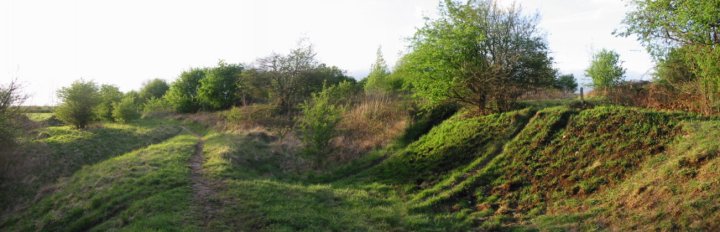
04/03. Northern bank and ditch. I think that’s Robin Hood’s Pot in the background.


04/03. Central platform, silted ditch running round it, eroded bank can just be made out in the right of the pic.
Access to the fort is easy enough. Just off the A6097 is a minor road, the footpath that leads up to the fort is well signposted from here, and there’s room to get a car off the road.
The fort encloses roughly a hectare. Entrances can be seen in the NorthWest and East.
The forts defences are still in good nick, a triple bank and ditch to the East altho’ this side is covered in trees, the size of the the defences is impressive,
on the West a bank ditch and counterscarp.
The site sits behind two large mounds, the one nearest the entrance, is called Robin Hoods Pot and at over 6m high is thought to be a barrow.( See Rhiannons post Robin Hood’s Pot )
A top place.
Bingham henge is sadly no longer with us.........
Well no actually it is.
It’s just been wrapped in a 1m layer of clay (for it’s own protection) and carefully placed under an industrial estates car park.
The really sad bit is...... I’m visiting industrial estate car parks..........
The henge is tucked away behind the petrol station in Gunthorpe Bridge, on private land, so a bit of gate hopping is in order.
The site is now badly silted up and eroded. A central platform can still be made out as can an entrance in the south-east. The north and western sections are silted up and a drain cuts thrugh the western part, using the henges ditch at one point.
A nice enough place, and worth a look if you’re in the area.
Information on excavations and sites in Derbyshire and South Yorkshire.
Lots photo’s, watercolours and info on Peak District sites. Good sections on Arbor Low and Gib Hill, Stanton Moor and various barrows.
Info on Arbor Low.
Photo’s of finds......and some great watercolours by Thomas Bateman, his aerial view of the henge is great.
Use the map on the site to find the Arbor Low section.
Info on Liffs Low. Pictures and watercolours of finds.

Standing stumps would be a more appropriate description of this site, I must admit I was a bit let down. For some reason the name had got me going.....
3 barely visible stumps, one less so than the others.
I don’t know if the old O.S map I have has them in the wrong place, it just didn’t seem to fit..... A guy who lived in a house at the top of the drive had seen me hanging around, became suspicious and asked me what I was up to. He showed me the stumps, and assured me they were what I was looking for after seeing the look on my face.
Disappointed I left with....with not even a photo.

The bog at the bottom of the hill Elderford mentions is there just about the year round and on my visit to the stones this year, last years stepping stones had just about sunk in the mud.
An excellent site, it’s small size gets me everytime.
Try and catch a sunrise at the stones if you can, you won’t be disappointed.
Although Caer Leb is a bit eroded and silted up it’s still worth a look. A roughly square site with a lone stone stump just off centre.
I’ve read that Caer Leb was first thought to be a Medieval moated site but after excavations Roman coins were found so it was then attributed to them instead. Now after excavations at a similar site at Llansadwrn have shown it to be 2nd Century BC, Caer Leb is now thought to be originally Iron Age, and used at various times through the centuries.

Don’t you just hate it when you can’t get close up to something. I don’t mind a bit of trespass once in a while, but heavy duty barb wire fencing kept me out.
From a distance the stone looked to be over 7ft tall and quite impressive.
Oh.......
This can look so right.
So how can it look so wrong at the same time?
I was lacking a bit of time so I didn’t really get to have a proper look for this site. But on the same side of the A5 as this burial chamber a field or two closer to Bryngwran there is a small stone quite high in the fields.
A great site, although I’m a bit unsure of the restoration techniques on Anglesey, an overuse of bricks me thinks. But it’s one of the sites that they can be easily ignored.
There is a small stone further up the road from the chambers in the opposite direction to Ty Mawr approx.SH259801, it stands on a small mound with a few smaller loose stones around it. Not O.S marked, so it may be nothing.


04/03. Structure with the stone sink.

04/03. Stone sink in one of the’huts‘


