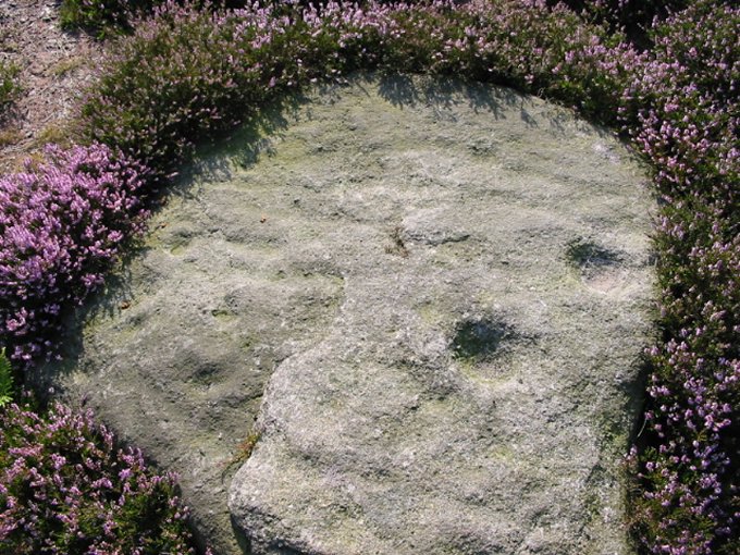
08/03. This small stone is also within the enclosure.
08/03. This small stone is also within the enclosure.

West of the Idol Stone and below Green Crag is an enclosure which according to the NMR has the remains of rubble banks, cairns, an upright stone and 7 carved rocks.
But seen as the place was snided with flying ants I didn’t get much of a look around the place.
The carved stone in my pic is right next to the path about halfway up the slope.
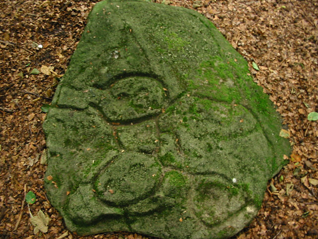
Rock art in Sheffield?
A large carved sandstone slab with 3 ovals surrounding several cup marks. The ovals have been cut so deep one of the platforms with the cup marks on stands proud of the stone. Several ‘gutters’ are also carved which just about surround the whole of the other carvings. A corker!
I reckon the best place to start is on Whirlowdale Road, near to the junction with Whirlowdale Crescent. Take the path on the corner and follow it thru’ the woods along the line of the gardens that back onto the wood. The first stream you come to (dry in summer) head off left into the trees for about 70m, the stone is in a clearing and is clearly visible.

07/03. Not the best of pics but it shows more cup marks on a ledge buried under smaller stones.
Just down the road from Longside Moor on Holy Moor is an excellent carved rock. Recently discovered amongst the stones of a large medieval field clearance, it has about 46 cup marks and a worn ring carving.
It’s not known where the stone originally came from.
Follow the path that starts from SK320691 and at the second field along head diagonally left to a stile. The stone is in the first pile of clearance stones over the stile.

About 1km NNW of the Swine Sty enclosure is a disturbed cairn, resting on top of the biggest stone in the cairn is a small cup marked slab.
I can’t really think of decent directions to the cairn as it stands all by itself almost lost in the heather and bracken in the middle of Big Moor.


You know it’s time to give it a rest when you start looking for pit alignments in the summer grass and bracken.
100m ENE of the standing stone there’s a 300m run (east-west) of square pits dating to the Bronze/Iron Age. Clay lined they would have at one time been capable of holding water.(In fact they still are, some of the less visible ones at the far eastern end are only visible in winter as they still fill up with water).
Oh yes indeedy......
A truly awe-inspiring site. Battered it may be (or Bull Ringed as we say in Derbyshire)... but like wow!
“If you go down to the woods today.......”
An excellent site, I was a touch worried about the trees before arriving....but there was no need.
After using the ditch bottom to walk round the henge I was surprised to see just how well defined the henge actually is........

I was lucky enough to have Fitzcoraldo show me the Upleatham barrow and the cup marked kerb stones.
Being used to Derbyshire barrows I thought Upleatham was quite impressive, although it’s tree covered it’s still a good height.
But the highlight without doubt was the cup marked stones. I’ve got to admit it was a real buzz uncovering the heavily marked stone.
The views through the breaks in the trees are excellent; it’s great to see the contrast of Roseberry Topping and Eston Nab alongside the industrial coastline to the north.
Cheers Fitz.

170m to the east of the Eagle Stone is a ruined ring cairn on the northern edge of a small cairnfield.
The ring cairn is roughly 17m in diameter, the rubble bank is very overgrown but is on average 40cm high and 2m wide. The northern section of the bank is lost to 2 hollow trackways.
Hardly impressive it does however have some excellent views to the White Peak in the south.

06/03. Showing the central and side dishes. Overall the circular carving is 50cm across.


The entrance to the north was built and then blocked by a cairn. It’s thought the entrance may have been ‘symbollic’ in some kinda way.
There are traces of the wall/kerb left across this entrance.
The trees mean you have to leave the circle and move to the edge to get the best view... NW to Win Hill and the hills of the Derwent Vally beyond.


The threat of eviction continues to hang over the Stanton quarry Eco-warriors after planners called for a further report on the legality of the protest camp.
A Peak District National Park (PDNP) planning committee examined the Stanton Moor site on Friday morning at the request of the Stanton Action Group (SAG) and the parish council.
A decision on whether to take enforcement action against the Eco-warriors could be taken by PDNP members in July after the full report is published.
The protesters have been campaigning for three years against proposals to reopen the quarry.
John Bull, chairman of the PDNP planning committee, said: “The real issue on Stanton Moor is whether these quarries should be reopened.
“However, we need to consider all aspects relating to this proposal and that is why we have asked for a further report.”
But the protesters, who have erected at least 47 structures on the site, say Friday´s decision has only increased the anxiety over possible eviction.
Campaigner Ben Hartley said: “Indecision on the part of PDNP has left us to worry for even longer. But at least the report will give more people an informed view.”
With the site occupation approaching four years, planners had feared the protesters could exploit a planning loophole which gives protection to permanent buildings after that time.
More at:
matlocktoday.co.uk/ViewArticle2.aspx?SectionID=749&ArticleID=529747
Robin McKie, science editor
Sunday June 15, 2003
The Observer
Archaeologists have discovered 12,000-year-old engravings carved by ancient Britons in a cave in Creswell Crags, Derbyshire. The depiction of the animals – which include a pair of birds – is the first example of prehistoric cave art in Britain.
The discovery – by Paul Bahn and Paul Pettitt, with Spanish colleague Sergio Ripoll – is set to trigger considerable scientific excitement, for it fills a major gap in the country’s archeological record.
‘If this is verified, it represents a wonderful discovery,’ said Professor Chris Stringer, of the Natural History Museum, London. ‘There are fine examples of cave art in Spain and France but none has been found here – until now.‘
Full story at:
observer.co.uk/uk_news/story/0,6903,977770,00.html

This is another site from Barnatts book, and another ring or robbed cairn.
Although it’s buried under thick dead bracken.......I’d go for a robbed cairn, it’s not as tho’ I’m an expert or owt.
This is located on the second ridge that crosses the moor. A large bracken covered lump. Easy to spot on the ridge, when the brackens died down.
Not much to see

A small ring cairn 11m in diameter. Grass covered rubble bank. It has a small stone on the bank in the east, it lays flat in the bank, if it did ever stand it would be under 50cm. Barnatt says it might be a kerbstone or a standing stone.
It’s situated in a grass clearing in amongst the bracken. On the first low ridge north of the main track across the moor.
Excellent views as with all the Beely sites.

Possible ring cairn with central cairn, Barnatt suggests a robbed cairn due to it’s closeness to the stone wall.
Tricky to find, wouldn’t like to say whether it’s worth the fight through heather and peat bogs.......but hey it’s there.
OK so this ring cairn is hard to find and when you do..... it’s a bit of a let down, just a ring of slightly higher than the rest heather. But the views are outrageous. With Win Hill, framed by Lose Hill and Mam Tor in the west and the Derwent Valley and Crook Hill to the north.
If there were stones remaining here......it would certainly be one the Peaks best sites.


A small cairn 6m in diameter, and may be 1m high surrounded by 5 standing stones, 2 of which lean badly. A bit of confusion as to what exactly the site is.....kerbed cairn or in-filled stone circle.
A real pain to find, and the moor is wet for much of the year round.


05/03. The smaller Southern Circle is a bit hammered, this arc on the other side of the wall is probably the most distinctive section.


A large grass covered rubble ring, approximately 18x15m in diameter. The width of the bank varies between 1m & 5m.
There is a large gap to the north. It may be a ring cairn, although J.Barnatt suggests with it laying next to wall stone quarries it may be a robbed cairn.
From the standing stone on Smelting Hill, follow the wall along until you reach a large disturbed barrow. Over the wall here, go to the far side of the field. The ring/robbed cairn is near the edge between 2 small walling quarries.
Excellent views.....nothing really to see of the cairn.


05/03. Looking into the cairn thru’ South entrance. Higgar Tor in the background, Carl Wark to the right.
At last!........
After what must be double figure attempts, both singily and combined. The mighty Neil and I finally found this ring cairn. To say we’ve missed it so many times.... it’s quite an impressive site.
The stones that make up the cairn are alot bigger than any of the other Derbys’ ring cairns, some of the stones looked as if at one time they may have stood (thats only going on the shape of ‘em).
Right on the banks of a stream. Stone free interior and with a definite South facing entrance.
On a clear day the Beech trees at Minninglow are easy to spot on the distant Southerly horizon.