


In the 18yrs I’ve been going to Barbrook III.....I don’t think I’ve ever seen it properly.
Until now that is.....the moorland fire that has slowly burnt out over the last few days or so has stripped back all the long grass over quite a large area....(the ground was still warm and smoking in places).
Barbrook III has always impressed me.....but even more so now...
All the stones are quite visible as is the bank....Stones that before were seen as being only a few centimetres above the grass... are now a decent height....
I’d suggest getting over there as soon as you can and see the circle before the grass makes a come back.
Info on Long Megs’ Enclosure and Cursus.
Extracts from the SMR.....
Immediately to the north of the stone circle, and partly overlain by Longmeg Farm, aerial photographs have identified the infilled ditch of a roughly circular enclosure measuring some 210m north-south by 200m east-west. At the point where the stone circle and the enclosure virtually touch, the stone circle has been flattened slightly in shape suggesting that the enclosure was already in existence and the stones arranged so as not to disturb this earlier
feature.
To the west of the stone circle aerial photographs have identified two infilled ditches of a cursus running for approximately 600m from the cliff above the River Eden to the entrance on the south western side of the stone circle. The ditches are virtually parallel and c.40m-50m apart. The western end of the cursus is terminated by an oblique ditch also visible on aerial photographs. The eastern end is less clear; the northern ditch appears to run to the edge of the stone circle, the southern ditch, however, cannot be traced quite this far on existing aerial photographs but it is reasonable to assume that it also continues at least to the stone circle.
In Stan Beckensall’s book ‘Prehistoric Rock Art In Cumbria” there’s a fancy infra-red aerial photo of Long Meg...the enclosure is easy to see......at the top of the photo is a dark stripe...is this the Cursus perhaps?
The area around Gibbet South was burnt off at the end of Feb 2004, and for the first time in quite a number of years the stones and rubble bank of the circle are quite visible.
Although it has to be said it’s still nowt to get excited about.


There are 5 stones stretched out along a distance of 330m on Min-End Lane. 2 pairs and a single stone. They’ve all been used as gateposts in their time, and stand on the line of an old stripped out drystone wall.
The Cheshire Monuments lot, reckon 3 of the stones could be prehistoric in origin. (These are the pair furthest north and the single stone to the far south, with the modern gateposts in between).
The prehistoric idea seems to come from the stones looking different to the ‘modern’ squarer gateposts, (which seems to suggest that there is a kinda ‘model gatepost’) and the fact that they lean.
Not sure I go with it myself.....worth checking tho’ out for the views alone.
What is it?.....barrow or stone circle?
Low grass covered rubble bank, around 13x11m in size, bank broken to the NNE & SW. With several large-ish stones on the banking.
The stone circle theory comes from a geezer named W.Andrew...who described the site as ‘being a stone circle similar to the 9 ladies.’ the rest of his description is a bit confusing....but he makes no mention of seeing upright stones and describes it much like it is now.
Barnatt reckons on it being a robbed cairn and the stones around the bank being kerbstones.

Access to Minninglow has always been a bit of a shady area....
The information board at Minninglow car park reckons there is no public access up to the cairns. And there are no paths up there.
But....the surrounding fields are all open pasture... So as long as you’re polite and tell the farmer at Minninglow Grange what you’re up to...
This stone is north of the Church at Bradbourne....Tall and thin limestone slab (riddled with them crinoid fossils) and leaning badly.
The top has a wide notch like looking thing along its top....hard to say whether it’s been shaped like that or not.
There are several vague references to another coupla stones that stood nearby. No sign of ‘em now tho’.
------------------------------------------------------------------------------------------------- The two missing stones are said to have been used in the construction of the bridge over the stream before you get to the stone.
04/11

12/03. The imaginatively named ‘Stone 4’....this stands 60-70m NW of the main standing stone.

12/03. The far eastern end of the pit alignment. These pits weren’t visible in the summer.
Not O.S marked.
About 350m SE-ish of the lake on the southern boundary of the Longshaw Estate.
I guess 8x8m in size, with nice sections of double kerbing.


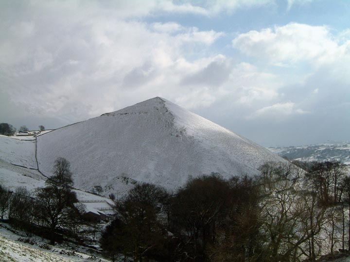
12/03. The stone in the top of the barrow. Shutlingsoe hill in the left of pic.
Toot Hill’s barrow is only a small affair, 8x9m and just under 1m high.
Barnatt noted the site as a possible barrow in his ‘Barrow Corpus’, since then though it has made it onto the NMR.
A small gritstone slab sticks out of the barrows top, about 50cm wide and 60cm tall....whether it is anything to do with the barrow seems uncertain.
Excellent views with the weird summit of Shutlingsoe visible in the SSE and the moors of Wildboarclough filling the eastern horizon.
The earthwork marked on O.S maps that stands on the summit of Toot Hill, is a deer pound from medieval-ish times when the Macclesfield Forest was a Royal Forest.
From Wirksworth I this stone is in the field to the east... 200m away.
Perhaps 50-60cm tall when upright... and a complete contrast to the other 2 stones which stand/stood either side of it.

In a rocky area covered with linear clearance banks on Gibbet Moor are 2 small standing stones, several metres apart. A much larger square set stone can be seen 40m away to the NW-ish.
Barnatt and friends debated whether the stones could be the remains of another four-poster....the size of the stones and the distance apart are much the same as Gibbet Moor North.
11/04.
The three stones are now thought to be what is left of an alignment.

Partial excavations carried out in 1958 and 1959 showed the cave to have been in use in the Mesolithic, Neolithic, Beaker, Bronze Age, Iron Age and Roman periods, and demonstrated in particular that the site was a Neolithic burial-cave. Beneath these deposits was found Later Upper Palaeolithic material, which included flint tools, charcoal denoting a hearth, fragments of antler, and pieces of bone showing marks of
cutting and crushing. The recently radiocarbon dated tang of an antler point indicates the cave was in use circa 11200BP (Before Present).
Extract from the SMR...
The roundhouse was sadly burnt down on November the 5th after a stray firework/spark landed in the houses roof.


I posted this up a while ago and then removed it..because it didn’t really go along with what Barnatt had written... and who am I to nay-say the mighty Barnatt... it’s back now though.
Rooke noted in the 1780’s that 3 stone circles and an augurial seat stood at Durwood Tor to the west of The Stride.
Barnatt made mention of Rooke’s lost circles in his book of 1990 and had them as being in the area of Dudwood Farm on Dudwood which is to the south of The Stride.
There is no trace of the circles today, but under the south side of Durwood Tor is a stone shaped like a chair?...is this what Rooke was referring to?
A similar ‘augurial seat’ was said to have stood on Strawberry Hill in Leicestershire.
If I can add something to festboy’s misc. notes below.....
Although once thought of as a hillfort, Burr Tor is now thought of as a stock enclosure. One of the reasons behind the rethinking is that in the 1780’s some geezer named Cresswell described the earthworks as “neither broad nor deep.”
It’s a thigh-burning 150m or so climb to the little summit of High Wheeldon; home to the Fox Hole, a small hidden cave, in one of the areas most distinctive hills. The name of the hill has often been mentioned as being named after a stone circle....although no trace of one has ever been found.
It’s National Trust property and the path to the top is by Wheeldon Trees Farm.
The entrance to the cave is hidden away on the NW side of the hill. About a 25m walk down a little ridge from the top.....and as with most of the Peaks caves, archaeologically significant or not, the entrance is gated and padlocked. The entrance is larger today after dynamite was used to blast it out in order to help rescue a dog in the early 20th Century.
The cave has been occupied throughout prehistory beginning in the Paeleolithic, while in the Neolithic it was used to house a burial, the bones being the oldest known bones yet recovered from the White Peak. Some of the finds from the caves are/were displayed at the Buxton Museum.
The views from up here are outrageous thru’ 360’.

11/03. Entrance to the Fox Hole Cave, High Wheeldon’s summit behind.
03/05. High Wheeldon, looking SW from the Earl Sterndale to High Needham road. The cave is located near to the top of the rocky spine, visible in the middle point of the hill

11/03. Top of possible outlier at Ewden Beck, looking across circle (35m away) to Salter Hills in the east.....When Barnatt was Barnatt and not the educated/straight Barnatt we know today. He suggested this was the alignment for the equinox sunrise.
More on the double sunset viewed from Leek.
Although the place to view it from today is Glutton Bridge.

10/03. The view northwest-ish from the top of the cairn, Parkhouse Hill and the larger Chrome Hill behind.
Jewitt and Lucas excavated/dug the cairn in the 1840’s and discovered 4 rock cut graves and 4 cists....Two of these contained burials along with food vessels, flints and an axe hammer. (Finds J.Barnatt’s & J. Collis’ “Barrow Corpus”)
Today, Glutton Bridge below Hitter Hill is also the best place to pick up the ‘double sunset’ behind Chrome Hill. This happens a few weeks either side of 21st June.
The cairn on Hitter Hill is well battered and stands in an area of old mine workings.
It’s probably not worth the steep climb up Hitter Hill from Glutton Bridge to see the cairn....But the views from the cairns top are outrageous...with the old coral reefs of Parkhouse Hill and Chrome Hill dominating the northern view and the pyramid hill of High Wheeldon (home of the Fox Hole Cave) in the south.
The two stones are in a fenced enclosure about 50m from the road....Unsure of public access, but there is a large gate into the field where the stones are.
Nowt much to say about ‘em really...one stands, the other don’t.
This stone struggles to be noticed....built into a drystone wall and covered by brambles.
The stone is opposite a line of terraced houses on the main road through Bladnoch....It can be tricky to spot.....(look for the top of the stone as it is higher than the wall).

10/03. The outline of the massive platform the cairn stands on can be made out in the right of the photo.

A TV archaeologist criticised a county council today over the destruction of the landscape around one of Britain’s top prehistoric sites.
Thornborough Henges, near Ripon, has the greatest concentration of late Neolithic and early Bronze Age sites in the country.
It represents the largest prehistoric quarrying operation in Britain and construction firm Tarmac has proposed extending its activities in the area.
Dr Mark Horton, a presenter on the BBC’s Time Flyers programme, criticised North Yorkshire County Council over the destruction of the landscape around the site.
Dr Horton, head of archaeology at the University of Bristol, said: “I’ve been appalled by what I’ve seen at Thornborough. Archaeological sites like this should be protected and plans such as these shouldn’t even be proposed.
“That such landscape destruction could even be considered around Stonehenge, or even our lesser-known sites in the south, is unthinkable. “Yet at Thornborough, it is OK to seriously consider the total loss of a prehistoric landscape, arguably as important, for simple economic gain.’‘
North Yorkshire County Council permitted Tarmac to quarry in the area in 1994 with “only a very limited archaeological survey’’, Dr Horton said. Nosterfield Quarry in Thornborough is one of the county’s most important quarries, producing more than 500,000 tonnes of sand and gravel each year, but supplies from the existing reserves are expected to run out within three years.
Full Story:
thisisnorthallerton.co.uk/the_north_east/northallerton/news/NEWS0.html

This was a crazy one.....the sun was low in the sky and lit the carvings up perfect but when the sun went behind the clouds awhile the cup & rings went with it..


