


Measuring 16x16m and below 0.5m in height the barrow is dated to the Bronze Age.
Excavated in 1825 by William Bateman and in 1844 by son Thomas. Traces of burnt bone from a cremation were found along with later Anglian additions.
The barrow measures 16x12m by 0.5m high, dated to the Bronze age,it is topped by the socketed base of a medieval cross.
Thomas Bateman excavated in 1846 discovering a central cist and the disturbed remains of three adult and two infant burials accompanied by burnt bones, pot
shards, flint tools, and parts of a shale bracelet and a necklace delicately made from jet and ivory.
Both the cist and the barrows kerb both noted by Bareman have been removed at some point.
Sited above a gritstone outcrop this is a circular cairn about 13x13m and 1.75m in height.
Although disturbed there are no records of any excavations.
23m by 20m and standing some 2m high and dated to the Bronze Age.
Excavated by Thomas Bateman in 1849 whose finds included a limestone cist containing a crouched skeleton interred with a
flint implement. On the cist’s capstone was a smaller limestone cist which contained a collared urn containing a cremation burial along with a flint tool and a pot shard.
Bateman discovered a further 3 more similar burials within the barrow itself. A 5th burial consisited of a skeleton which had been
skeleton which had been either burned/defleshed, the long bones being laid parallel to one another whilst still fresh.
Other cremated human remains were found within the barrow including one in an urn.


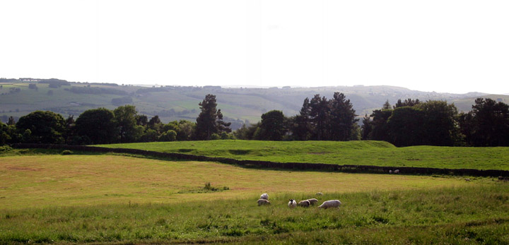
07/06. To the right of the barrow are Hawks Low, middle distance and Moat Low beyond that on the far horizon.
Blackstones Low stands at 295m above sea level, in a scrub landscape, on the geological border between the carboniferous and dolomotised limestones.
Well preserved the barrow enjoys, making allowances for the hideous Ballidon Quarry, some wonderous views over an ancient and historic landscape that includes Minninglow, the Roystone Valley, Black Rocks and the Longcliffe Crags; the location of Rains Cave.
Located on Open Access land the barrow is relatively easy to find although a parking spot close to the site is difficult. Although the barrow could quite easily be included in a trip to the Roystone Valley.
Local rumour has it that after 7 years of slumber the Middle Peak Quarry is about to be reworked and even better..... extended. Unfortuantely the stone and, to a much lesser extent, the narrow road that passes it by are likely to be amongst the casualities. An alternative road/route already exists and well the stone.....is just a stone to a lot of folk living in Wirksworth, that is if they know it’s there at all.
So along with the extensions to the quarries around Stanton and the recently approved plans to rework and extend the rakes on Longstone Edge it would appear that the Peak is all out to invert itself....

06/06. Three barrows on Calton Pastures, from the Moatless Plantation.
Explored between 1958-1963.
Finds included three pieces of worked flint, sherds of a Bronze Age collared urn, some sherds described as earlier in date, two worked antler fragments in association with some animal bones, a range of faunal remains including bear, reindeer, hare and cat, and a bone point of possible Upper Palaeolithic date.
There are 4 supposed/possible/probable/likely barrows on Daisy Bank; at SK2060 5649, SK2060 5650, SK2057 5648 and SK2065 5670.

04/06. The barrow with the familiar landmark of Minninglow’s beech trees behind.


03/04. Looking across the barrows ruined cist to the nearby Roystone Rocks Barrow.

04/06. Low barrow just visible in the trees, nothing shows above ground of the massive limestone kerb that surround(ed/s) it.
T. Bateman excavated some of the barrow, more than likely heading straight for the primary burial, in 1857. He discovered a crouched burial on a bed of clay within a rock-cut grave, also found in the grave was a bone tool, several flints and an early bronze age decorated drinking vessel.


04/06. When first noted the kerbstones formed a complete circle. Today this section of stones, along NW edge, are the most prominent part of the barrow. Other stones can be found with some poking around.


05/06. In his book ‘Walks in the Ancient Peak’ Robert Harris notes two standing stones aligned with the barrow. The stones are in the field west of Boars Low on the opposite side of the A515.
Not convinced myself like....
A 3rd stone can be seen in the distance (top left) but is not mentioned by Harris.


03/06. The barrow with the tree topped hill of Aleck Low in the distance.
Further to danieljackson’s fieldnotes [removed]:-
The three stones referred to... while not modern... aren’t prehistoric either unfortunately. The single stone in the photograph [removed] is a Medieval boundary marker known as the Moat Stone, while the pair of stones are more than likely old gateposts, there are wall foundation stones along this alignment which can be found after a bit of poking around. Again. that’s not to say the stones are modern..... Gateham Grange, within very casual spitting distance of the stones, was part of the important Anglo-Saxon manor of Alstonefield, and the area was farmed at least from the 11th Century onwards.

A mini “Stonehenge” has been uncovered by archaeologists in Cornwall.
The 5,000 year-old “circle henge”, an early religious site, was discovered during work on the A30 bypass at Goss Moor, between Indian Queens and Bodmin, and is the first of its kind found in the region.
The 10 metre diameter site at Deep Tye Farm, which could have been the setting for human sacrifice, has excited archeologists. Stuart Foreman, from Oxford Archaeology, which is doing the work, said: “Excavated sites of this period are comparatively rare in Cornwall.”
The excavation, costing £500,000, is part of a planned set of examinations by archaeologists working ahead of road builders on the £93 million Goss Moor bypass. The discovery won’t delay work on the road. The henge was unearthed less than a mile from the Castle-an-Dinas hillfort by a 10 metre wide trench that has been dug along the entire seven kilometre length of the bypass route.
Also known as a “pit circle”, the circle henge dates from the late neolithic, or “new stone” period, between 3,000 and 2,000BC. “The site is an important one for the region,” said Mr Foreman. “The Deep Tye Farm site is a modest example of this type of monument, which can reach quite lavish proportions. Stonehenge is the best known example.”
Large-scale henge monuments are known in the region, including the earthwork at Castilly Henge, which lies at the eastern end of the road scheme near the Innis Downs roundabout. Mr Foreman explained that the site unearthed was relatively small compared to others.
11:00 – 18 February 2006
www.thisisdevon.co.uk
Major Hayman Rooke suggested that the name of Rootor came about in reference to the outcrops rocking stones, of which there once were reputedly 8 or 9.
The word ‘roo’ being an old Peak(/English?) word for something that moves “to and fro”.
The village of Birchover was also once known by the same name, Rowtor/Rootor.

02/06. Low rake sunlight and bare trees provide a rare opportunity to see the carvings around the central cup and ring motif. Note incised lines too in centre left of photo.

Also known as John Stump, the Head Stone is another example of a Peak District stone that is said to turn around on a ‘certain’ morning each year on hearing the cocks-crow. (others include Baslow’s Eagle Stone and the Cuckoo Stone in Matlock)
Visitors to the stone in late August with the sun highlighting its western face have also reported seeing a human face.
David Clarke’s ‘Ghost and Legends of the Peak District‘
(The ‘certain’ morning is not revealed by Clarke)
Simon Jenkins
Friday January 27, 2006
The Guardian
This world heritage site is a national disgrace. Consultants have made millions but achieved nothing in 20 years.
West of Amesbury on the A303, the road dips and rises towards a meadow in the distance. In the meadow stands a clump of grey stones, looking like dominoes rearranged by a shell from the neighbouring artillery range. The clump is Britain’s greatest stone-age monument.
Nobody can touch it. Stonehenge is cursed. I have bet every chairman of English Heritage – Lord Montagu, Sir Jocelyn Stevens and Sir Neil Cossons – that no plan of theirs to meddle with the stones will ever work. This week the latest tunnel proposal collapsed, following last year’s rejection of a new visitor centre. The fate of the site is consigned to that Blairite neverland called “consultation”, joining St Bart’s and Crossrail among the living dead, projects which move only because they are maggot-ridden with costs.
Article continues at: guardian.co.uk/Columnists/Column/0,,1696043,00.html

01/06. Excellent cist on Swine Sty overlooking the Bar Brook.

01/06. This upright stone near the cairns centre is suggested to be the possible remains of a small cist.


01/06. Looking across the barrow, at SK275 754, to the Barbrook I stone circle (stones marked by red dots). The barrow is sited below the crest and isn’t visible from the stone circles.

01/06. The largest of the Swine Sty barrows. SK275 754.
John Barnatt seems to have binned his theory of the moor being divided, by the Bar Brook, into separate working and ritual areas after his survey of a few years ago.
The location of the Barbrook V ring cairn on the SW limits of the field system always caused me a bit of doubt over whether this was the case.....Barnatt andAinsworth’s survey of the moor a few years ago turned up 5-6 barrows, which were previously thought to be large clearance cairns.
Details of whether the opposite took place and field systems were laid out on the eastern side aren’t so forthcoming....

Samuel Hieronymous Grimm’s painting, 1785, of the gorge before the dam.


