
Open Data LIDAR: Henges
Image source
The following images are obtained from the recent releases of open data LIDAR by The Environment Agency and Natural Resources Wales. I’ve used this amazing dynamic map which has been created to use the open data. Thank you to all concerned for your time and resources!
Picture Selection
I have gone through all sites categorised as Henges on www.themodernantiquarian.com checking if a) LIDAR exists and b) they are visible to my untrained eye. This has unfortunately trimmed 70% or so of the listed henges.
All henges in Scotland and Ireland are right out. A high percentage of those left are missing LIDAR. Thornborough North and Central, Arbor Low, The Bull Ring and half of Mayburgh are some of the better known casualties. Those where LIDAR exists but we don’t see them can be categorized as small henges less than 20m wide which presumably have shallower ditches, lost to quarrying, buildings and agriculture.
Each picture is at maximum resolution, so you can download two (or twenty) and directly compare them.
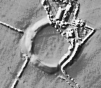
Open Source Environment agency LIDAR

Open Source Environment agency LIDAR
LiDAR Composite Dataset.
Contains public sector information licensed under the Open Government Licence v2.0.

LiDAR Composite Dataset.
Contains public sector information licensed under the Open Government Licence v2.0.

Open Source Environment agency LIDAR

Open Source Environment agency LIDAR

Open Source Environment agency LIDAR

Open Source Environment agency LIDAR

Open Source Environment agency LIDAR

Open Source Environment agency LIDAR

LiDAR Composite Dataset.
Contains public sector information licensed under the Open Government Licence v2.0.

Open Source Environment agency LIDAR

Open Source Environment agency LIDAR

Open Source Environment agency LIDAR

© Environment Agency copyright and/or database right 2015.

Open Source Environment agency LIDAR

Open Source Environment agency LIDAR

Open Source Environment agency LIDAR

Open Source Environment agency LIDAR

Open Source Environment agency LIDAR

Open Source Environment agency LIDAR

Open Source Environment agency LIDAR

Open Source Environment agency LIDAR

Open Source Environment agency LIDAR

Open Source Environment agency LIDAR

Open Source Environment agency LIDAR

Open Source Environment agency LIDAR

Open Source Environment agency LIDAR

Open Source Environment agency LIDAR

Open Source Environment agency LIDAR

Open Source Environment agency LIDAR

Open Source Environment agency LIDAR

Open Source Environment agency LIDAR
Nice job J, these images are terrific.
Thanks very much for taking the time to do this..fascinating. Knowlton looks particularily interesting. OK, grovel time..I can't download the Lidar site due to obsolete tech: any chance of Eggardon Hill and/or the adjacent Powerstock Common images if they exist? The two sites with the strangest vibe that I've visited.
Thanks guys. I'm wondering about redoing it so they are embedded and are the correct relative size to each other. Spencer, Eggardon & Powerstock is sadly not covered by the LIDAR, neither are the majority of sites on or off the A35 including 3 bank barrows I wanted to "get".
Never mind, thanks for looking, J. I saw your fieldnotes for Eggardon and that the place had made an impact on you too. I got more out of that place than any of my visits to Maiden Castle. As for Powerstock Common/Forest: deeply spooky..felt more there than 'just' a barrow. A brace of sites where the hair went up on my neck...and I hadn't read anything about either beforehand.
Thanks for taking the trouble...
Thank you muchly for continuing to upload Lidar images. What you are doing is a fascinating, and I'd go as far as invaluable, addition to the TMA database, imo. I hope, since these are public, that others join in...wish I had the tech to do so. Cheers.
Great stuff. You must have an eye for recognising henge monuments. I need someone to look at a possible newly discovered henge in Nottinghamshire. How can I send you a Lidar image please?