
Simple things...
Image credit: Robert Gladstone
Simple things...


Moel Siabod rises beyond...

Towards Llanrwst...


Wondrous position overlooking the Conwy valley..

This has been on the list for years... suffice to say, shouldn’t have been.
“I’ll catch a rainbow from the sky, and tie the ends together” …
A shufti at Cerrig Cynant Stone Circle, moving on to the northern of the two Bryn Poeth Uchaf Ring Cairns
Ridiculed by many.... But not by I. Nor, I would assume, by those that have walked these heights...
For me, guitar playing at its very finest.
A reminder to always check out the summit of even the lower Welsh hills... you never know,
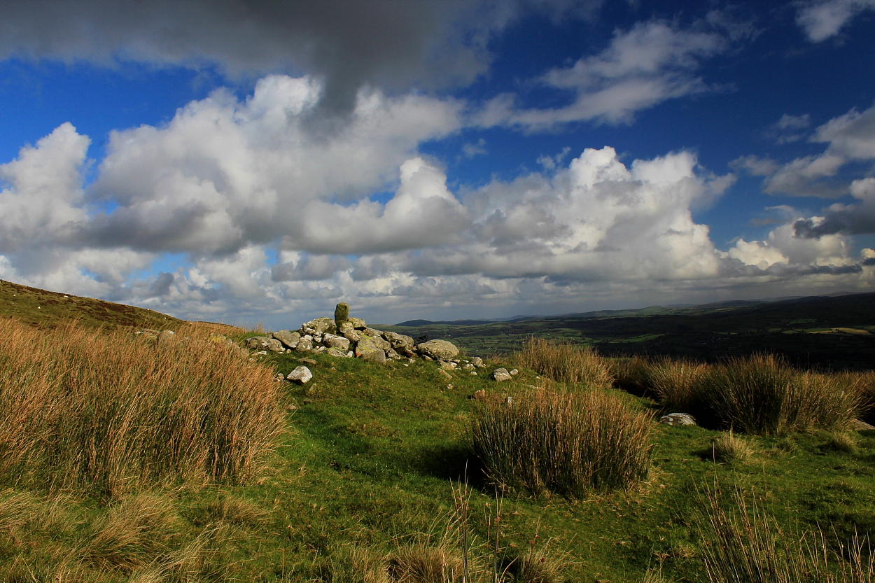
There are a number of ‘Moelfre’s across the length and breadth of Wales... hardly surprising, since I understand the name basically means ‘hill’. This one, however, has been on my ‘list’ for some time since it is one of the few featuring that iconic ‘Antiquarian typeface’ on the OS map.
To be fair, however, I arrive at Bwlch Glynmyndd to the north-east more in anticipation of the expected views than archaeological splendour. Needless to say, things are not as straightforward as they may appear from a simple perusal of the map.....
OK, the views ARE magnificent, the deeply riven hills north of Pumlumon forming a twisted, convoluted landscape of sublime aesthetics. However, the expected site of the monument, indicated below and to the southwest of the summit, reveals a ‘possible’ circular feature, probably natural? Certainly nothing to write home about. Fortunately, the views most certainly are..
Eventually, I return to the 1,539ft summit and everything suddenly becomes clear. For here is located what very much looks like a substantial Bronze Age round barrow, more-or-less inviolate. As it happens, the professional archaeologists agree, Coflein noting:
“A barrow, 17.5m in diameter, from 0.7m to 2.7m high, apparently undisturbed. There is no notice of any ditch. [J.Wiles 16.04.02]”
So what of the OS feature? Is this a mistake – plain and simple – or is there indeed something there?


At least someone had the sense to stick the power post BESIDE the cairn....


Looking approx west across the common... and numerous further cairns within this cemetery.


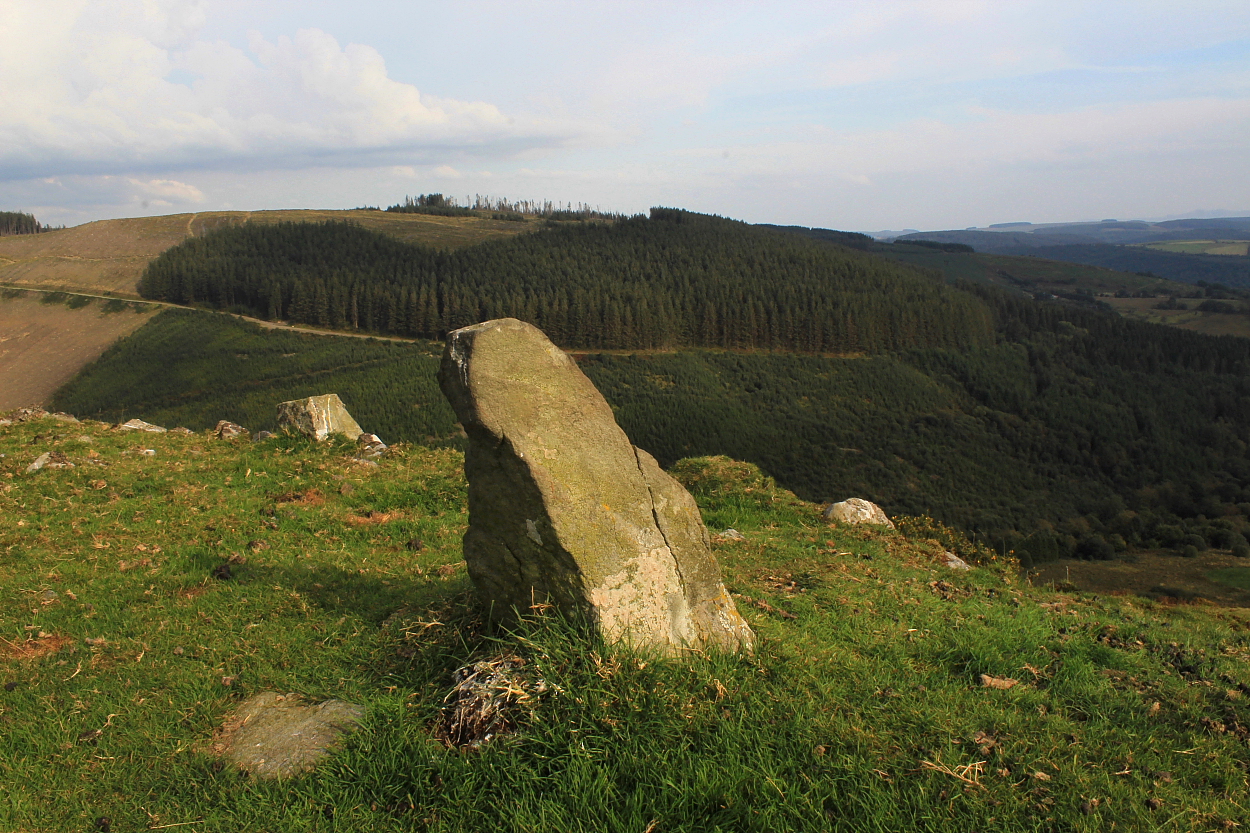
Garn Fawr rises beyond the little Carreg Garn Fawr... with Y Mynydd Du above all...
CADW scheduling (CM343) reckons:
“The monument comprises the remains of a burial cairn and an associated standing stone, both probably dating to the Bronze Age (c.2300 BC – 800 BC) and situated on the S-facing leading edge of a local summit on the SW-facing slopes of Mynydd Trawsnant. The grass-covered cairn, which probably utilises an outcropping bedrock knoll, is circular on plan and measures about 16m in diameter and up to 1.6m in height. An impressive quartz standing stone is situated about 45m to the NNW. It is a large block of stone, measuring 0.9m in height by 0.6m in width and 0.6m in thickness. Packing stones are clearly visible around its base.”
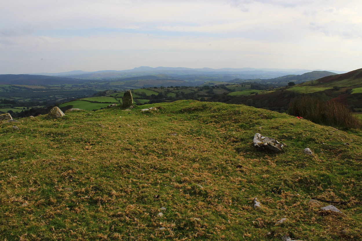
The salient feature for me – as always – however, is the magnificent vista towards the South Walian mountains, more than liberally crowned with Bronze Age cairns of their own. Oh and the wondrous vibe. This, truly, is a spot to just sit and watch for a few hours.... it would be a crime to rush, hence I deferred from a quick visit the previous late afternoon, kipped overnight above Llyn Brianne.. and spent the entire morning before a massive storm front none too subtly suggested I, ahem, move on.
Note the nearby quartzite stone which would appear to be associated with the great cairn. As CADW note, the obvious packing stones strongly suggest authenticity.

Looking south towards the Great Old Red Sandstone Escarpment of South Wales.. Pen-y-Fan and Corn Du are far top left, leading the eye across Fforest Fawr to Y Mynydd Du... upland cairns literally as far as the eye can see.


Looking across the plundered centre of the cairn to the distant Bryn-poeth Uchaf ring cairns and stone circle of Cerrig Cynnant. Note the associated little quartzite standing stone Carreg Garn Fawr centre left of image. Crowning the horizon will be the wondrous Cerrig Cewri and Carn Twrch.

Looking approx north-west towards the hills surrounding Llyn Brianne

While scheduled by CADW as Nant Gwyn, one can see why this great cairn is also referred to as Garn Fawr. Well, tell it like it is, right?


A pretty substantial ring cairn, this, with a well-preserved bank upon the southern arc and sweeping, extensive views to the apex of the South Walian uplands. A classic location, to be fair.
Coflein notes the following:
“Remains of a ring cairn on the SW-facing slopes of Mynydd Trawsnant, above Cerrig Cynnant. Circular on plan, measuring about 9m in diameter within a grass covered stony ring bank about 1.5m in thickness and up to 0.2m in height. The interior is level and largely stone free. [Source: Cadw scheduling description. F.Foster 05/04/2005]”

Although stone work is most visible upon the southern (far) arc, this is clearly a well-preserved monument..
Although not in the same league as the other obscure stone circles in the extended locale of Llyn Brianne (Bryn y Gorlan, Crug Siarls) this is still well worth the not-inconsiderable effort of visiting, if only for the excellent vibe – the nearby pair of ring cairns make it a no-brainer, should you be able.
Located a little north of the southern ring cairn, beyond an earthen field boundary, copious industrial strength upland grass and other sundry vegetation currently obscure what remains – above ground, at least – of this stone ring. I couldn’t discern anything still upstanding in the northern arc...
Although Coflein, in this instance, has nothing to add, the site is Scheduled, the CADW report (CM225) noting:
“The monument comprises the remains of a stone circle, which probably dates to the Bronze Age (c. 2300 – 800 BC). The stone circle measures approximately 20m in diameter and consists of eight stones set in a semicircle, with two further stones to the north completing the circle. The northern half of the circle, with only these two stones remaining, is presumably ruined, as the stones are only c. 20cm in height, some in the northern sector could be buried beneath the turf.”
Assuming you’ve the correct OS coordinates to relate to (preferably) your 1:25K map – the 1:50k will probably do, at a push – correctly identifying the location of this pleasing trio of sites is clearly not an issue. Getting there, however, isn’t exactly straightforward: I eschewed the long approach via the great cairn of Garn Fawr (with its little associated quartzite stone) in favour of a low-level stroll above the Cynnant Fawr, followed by a steep scramble to the west. As it transpired, choosing the hottest day of 2023 wasn’t ideal for such exertion, but hey. Stupid is as stupid does.
If you’ve only a day to spare, probably best to choose the former option and check in at the former Youth Hostel of Bryn-poeth Uchaf for a chat in passing – a neighbour I met the following day related how the current owner is very friendly to us outsiders. As it was, I instead met the (presumed) owner of Cynnant Farm who, while remaining silent, gave me a wry smile I took to signify a tolerance of my parking arrangements at the entrance to the public track traversing the cwm.


Looking SW across the ring cairn towards the great cairn of Garn Fawr.

Retrospective in the direction of my rather severe approach...

Looking towards the northern escarpment of South Wales...


Again, note my trekking poles defining the surviving arc... or at least what I could see remaining above ground.