
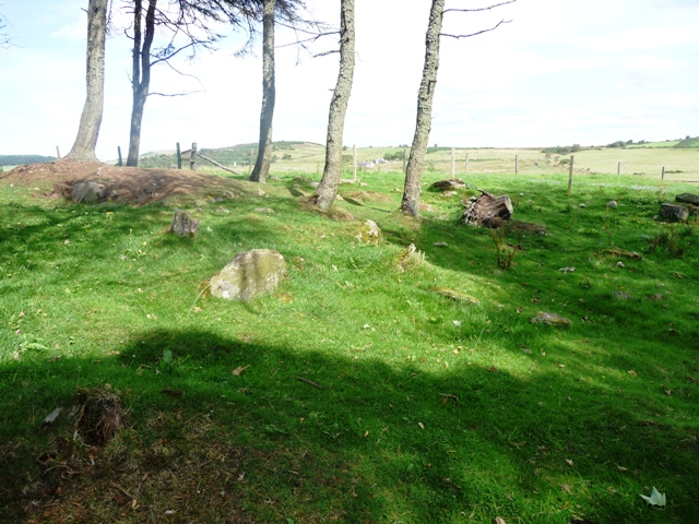
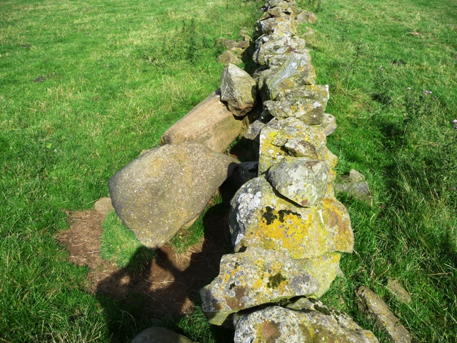
This cairn is about 11 1/2 meters wide by 31/2 meters in height. Built on top of a natural mound several scattered kerbs can be seen with only two still in place. Quite a bit of erosion has happened rabbits and hares have ably assisted in this. It is encircled by a rather ruined dry stane dyke. Some trees also grow on the cairn. However it was built in a very tranquil place with nice views across to Balmedie and south to Aberdeen.
I parked at the small wood inbetween Balmedie and Belhelvie on the B977. (Beside and opposite the mobile phone masts) The cairn can be seen quite clearly from the road. Three fences, one stream, Eigie Burn, needs to be jumped and a 1/2 mile walk over rural Aberdeenshire. On a nice day like today, lovely.
Visited 1/09/09.


A renowned musician has written an iconic composition which will be the basis for a lasting Homecoming legacy in the North-East.
Fiddler Paul Anderson was commisioned by Aberdeenshire Council to compose a piece of music and created Land Of Standing Stones to celebrate Homecoming Scotland.
The piece was inspired by Aberdeenshire’s dramatic natural scenery and in particular the large concentration of standing stones which are a significant feature of the local environment.
The work was played at a ceremony at Easter Aquhorthies Stone Circle near Inverurie on Tuesday afternoon.
Composer Paul Anderson said he wrote the piece at the Tomnaverie Stone Circle near Tarland as it is a place he often goes to compose music.
He said “The title of the piece was partly inspired by it being composed as Tomnaverie, but its more to do with it being representative of the whole of the North-East. I believe we have one of the greatest concentrations of standing stones and stone circles in the world and so Land of the Standing Stones seemed very appropriate as a title.”
Turriff Advertiser, Inverurie and Ellon editions also.
Friday 28th August No. 4847
The report goes onto to say background stuff and how local musical organisataions can be become involved. I have a recieved a copy of the invite so if you know of anybody wanting to contribute let me know in the comments posts. I’ll pass it on.
For further information:
aberdeenshirearts.org.uk/landofthestandingstones
(slightly easier listening than Mr Birtwhistle but beware some of it is Trad Scots........listen to often and a woolly jumper appears from nowhere!!)
A 3,000 year old Scottish cave dedicated to dead children has been brought to life for the first time.
First reported 2007.
More info :


Some images and all the discoveries found at this obviously well used place thru out the ages.
Sculptors Cave.
“On the beach below, (Hopeman Golf Course), is a proper wonder. Access is tricky, a hazardous descent on steep slopes and bare rock; or a slippery scramble around headlands on the shore at low tide. But we feel that a little danger adds spice to our wonder. More than two thousand years ago, spiritual Celts sought out this gloomy cavern for a grizzly cult: a pagan veneration of the human head as a source, symbol and esoteric power. The cavern roof was hung with severed heads: criminals executed for unspeakable crimes; warrior heroes decapitated in battle; apostates beheaded in bloody auto da fe; wise forebears exhibited for their posterity’s veneration. And later Celtic people – Picts on the cusp of Christianity – came here to chisel their arcane symbols into the soft sandstone of the cave walls. We have to search to find the sculptures – small and rudely carved among a gallery of subsequent graffiti.”
John R. Barrett
Walks and Wonders – Knock News No. 30
August 09
I approached this site from the north which proved to be an obstacle course. On the way back it was easier as I managed to find a bridge that crossed a stream instead of jumping. Gates instead of barbed wire fences. All the usuals. Take the first minor road east north of Methlick on the B9170. Keep going until this road ends at the Mill Of Sessnie. Walk back to Sessnie Croft and walk thru the field, over the bridge climbing the hill in front which will lead to a track. Turn south for 1/2 mile. The barrow is on the eastern side.
The barrow is has a ditch surrounding it which has all but filled up. Ground from the track to the barrow is also quite swampy in places. All the other details are in the Canmore pages, type Bellmuir. This area has many hut circles, causeways, a standing stone and probably most importantly the River Ythan. There are also rocky outcrops all over the place.
This place with its surroundings does have an aura about it. I know several sites have been excavated in the area and there’s a sense of maybe better things to come. Better to go on a nice day, and for a change when I visited it was.
Visited 23/07/09.
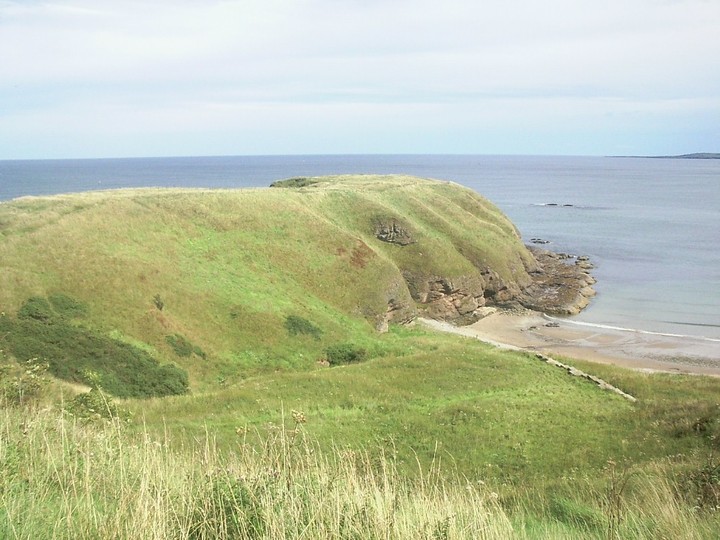
Crathie Point is one of a number of cliff forts in the area. The Iron Age forts at Durn Hill, Portknockie and Burghead being the nearest. All that is left at this magnificent setting is a northern rampart and a ditch at the southern point. Maybe the ruined wall is the remnants of the entrance. Both sides of the fort are sheer cliff face. Therefore the nearest natural harbour is at Sandend, 1 mile east.
To reach here leave the A98 before Cullen and follow the signs for Findlater Castle. Car parking is there. Just follow the path, the Buchan Coastal Walk, past the doocot and castle (which in it’s day must have been some place, stunning!) for about 1 mile. The ruins of the old wall/entrance mark the start of the fort. A very worthwhile walk and the coastal scenery is wonderful!
Visited 24/8/09.


The western flank. Nearest natural harbour is a mile east at Sandend.

Part of the northern rampart. You climb the cliffs and then are faced with this. No luck!


All the details about the remains of this fort which is situated just east of the highly spectacular ruins of Findlater Castle.

Anyone any idea what caused these markings on a rock near to the cairn?


Syd Halkett, the owner of Knauchland farm, kindly showed me an OS map from 1904 showing the original position of Kemps Cairn. The lid of the cist is kept beside a dry stane dyke up the small hill to the east of the steadings. It is 11/2 (approx) meters in length. Whoever was buried here must have been important as the views are wonderful.
Going south from Glenbarry, on the B9022, take the second minor road east and stop at Mid Knauchland farm. Ask permission from Syd and his wife, who are nice people and will give plenty of local information when asked.
Rhiannon deserves most of the credit as she pointed out that the cist was there in folklore notes for the nearby Conjure Cairn. Thank you!
Visited 24/08/09.


From the middle of the fort looking over to Pennan in the east.


One of the ditches, Pennan is the village in the distance.
Bennachie is a the highest point in the rural part of Aberdeenshire and dominates the skyline from all over the North East. Several paths lead up it. The Lords Throat, Bennachie vistor centre, the Rowantree (Maiden Castle and Mither Tap hillfort) and the Back O Bennachie at Oyne. The Garioch walk also meanders over the several peaks of the hill. There are also two Gouk Stones, ancient settlements, cairns and Archeolink. More famously the battle of Mons Graupius, from which the region gets its name, was supposedly fought between the Picts and Romans. It is easy to see why the “ancients” held the place in reverence. Also the legendary Jock O Bennachie giant stories are still well known up here. The hills at Barra, Dunnydeer and Tap O Noth all faced his wrath. Truly magical and always will be.
Most of the paths are well worn but the climb is steeper nearer the top. The Rowantree path leads straight to the Mither Tap hillfort, with Maiden Castle fort being located near the car park. On a clear day the views stretch all the way to the coast.
Visited loads.


From the northern approach looking east.
