

Tronach Point, another Iron Age fort beside Portknockie. Note the winding path, it can only reach the stack when the tide is out, unfortunately for me the tide was coming in.
Canmore’s discoveries at the coastal fort.
Portknockie, which means hilly port, is very pretty little village found on the Moray coast situated on the A942. The Iron Age fort is very easily found as it overlooks the harbour and village. Fortunately the locals have a good sense of history and have a marker board indicating the forts location.
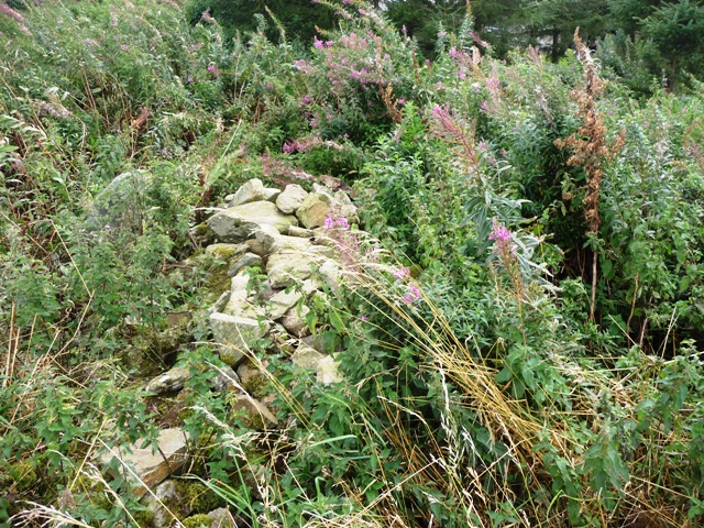
A fairly steep climb leads into the forts interior. Look west and the fort at Tronach Point can be seen. Southern ramparts remain whilst the other three sides are protected by cliffs. Within the fort are the remains of a fairly substantial building and several large holes possibly for large wooden posts. Many caves are also in the area. The harbour is on the forts western side.
It’s good to see the local community actively take part in looking after ancient history. In fact the fishing industry is taken very seriously here as several monuments indicate. No bad thing!
Visited 21/9/09.


Looking west towards Tronach Point another cliff fort. Also shows the remains of a building in the fort. There are also several deep holes.


Archeologists find the remains of a 2000-year-old roundhouse.
By Donna MacAllister.
News emerged 10/9/09.
Press and Journal 11/9/09.
(This story was brought to my attention, on Monday 14th., after the site tours. Sorry!)
More info and pictures on :


The barrow is in amongst the furze, didn’t go closer as the ground was boggy and I’d put on the wrong boots.
This barrow is to be found at the southern tip of Pitglassie wood. If walking from the northern barrow use the fields the way is barred by furze (jabby things), bog and fences. It is over ten meters in width and maybe a hut circle, according to Canmore. However it is easy to see why this place is here as there are excellent views to Bennachie, Knock and Noth as well as being surrounded by stone circles and standing stones. Chris had a theory about Broomend of Crichie, Inverurie being the center of a wheel with spokes leading to different sites. Perhaps these barrows are something similar cause there is a lot going on.
(To be fair the local farmer was going to get rid of all the trees and use the land for agricultural purposes. Thanks to the historic interest he hasn’t.)
Visited 7/09/09.


Near the trees in the distance is Pitglassie RSC.


The little stones are placed above the well weather worn cup marks.

Behind the trees is Logie Newton farm. Permission was given to wander up the tractor tracks.


The three kerb cairns are on the crest of the hill behind this standing stone, taken from the west cairn, it marks the spot where the urn was found.

The barrow is in the northern end of the woods in the middle of the image. Another is at the southern end which I’ve yet to visit. Picture taken from Pitglassie RSC. More pictures soon.
Bronze Age replica made from a single tree.
by Alison Middleton. First published in the Press and Journal 2/09/09.
A replica Bronze Age boat has successfully completed her maiden voyage across Loch Tay.
The rest of the story :
What they found at the very windy Iron Age fort.
With a cold and flu symptons affecting schools I had plenty time to investigate this Iron Age fort.
Leave the main road just south of Boddam at the Cadet signpost. Pull into the right at the gateway 200 meters away. Follow the path for 500 meters, past the ruins of Boddam Castle, heading towards the coast. This path, in parts boggy, leads to Dundonnie, a north eastern stack.
The fort is reached by crossing on a narrow pathway/coll. Be careful when climbing up and down the paths are slippy and muddy. A rampart covers most of the western side of the stack curving round and continues along the northern flank. Turf banks have been added. This fort must have been quite considerable in size as the stack is a 160 meters in length by 60 meters wide. At least two buildings stood in the forts centre, it’s highest point, one of which has had a seat built on top of it. Three sides north, south and east are protected by sheer cliff face. The nearest natural harbour being north at Peterhead bay.
Visited 2/09/09.


Looking north along the western rampart towards Boddam and the Peterhead Power Station.


This doesn’t mention any of the stone circles and thats the worrying thing. When you type “Hill Of Fiddes Stone Circle” in the search space no information can be found. Even worse the get in touch section doesn’t seem to work. Does this mean that they might be removed on the sly? I’ve no problems with wind turbines but does this happen elsewhere? Probably it does!!
This is situated about 100 meters to the north of the RSC nearer to the farm, on the Northern slopes of the Hill Of Fiddes. Another complete mess greeted me here as well. One stone bravely stands, 1 meters high 11/2 meters wide, whilst others have been toppled. Some have been covered in field clearance and some are overgrown. It’s a shame!
Visited 1/09/09.


More of the disgrace directly behind the recumbent.
I hadn’t looked behind this RSC the last time I was here. How I wished I hadn’t done this time! It’s hard to slag most farmers but this is a complete shambles. Circle stones have been flung on top of field/cairn clearance. Even a wind turbine, I did see that first time, must have required the moving of some stones although they had probably been already moved. It doesn’t even work!! Parts of farm machinery and waste heaps are close by.
Surely there must be laws against the vandalism of this nature. Angry now!
Re-visited 1/09/09.

From behind the recumbent, what a shambles, a fuckin disused turbine. No surprise there then!
