The shelter built from the wreck of the cairn. Pumlumon (I think) on the distant skyline.
Image credit: A. Brookes (13.5.2023)
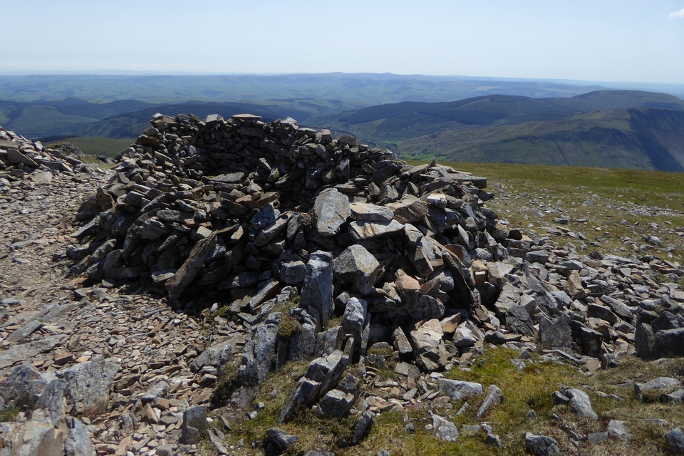
The shelter built from the wreck of the cairn. Pumlumon (I think) on the distant skyline.

Mynydd Moel from the cliffs to the west. The summit is marked by a rocky outcrop with a cairn on it (top right), but as a result the Bronze Age cairn is out of sight from this angle, interestingly.

Llyn Gafr below the towering cliffs of Cader Idris, seen from Mynydd Moel.

The settlement is to the right of the smaller lake (the larger lake is Lyn y Gadair). Elevated view from Pen y Gadair. Yr Wyddfa distant centre skyline.

Carnedd Lwyd just to the left of centre, over the plunging cliffs of Cyfrwy. Barmouth and the Mawddach estuary can just be seen beyond, with the hills of the Llyn floating on the horizon. From Pen y Gadair, the summit of Cader Idris.

The view from above Bwlch Cau to the north that few of the visitors to Pen y Gadair seem to seek out, just me and some sheep on an otherwise busy day. Looking towards Craig Cwm Amarch, with the softer peaks of the Tarrenau hills beyond.

Looking down on the lake from Craig Cwm Amarch to the west.

Llyn Cau in its mountain cradle, from the path up to Craig Lwyd.

A contrast to my previous visit in filthy November weather, the quartz boulder in Spring splendour with bluebells.


The football pitch is behind, but sadly the team has folded following Covid-suspension of the league.

Looking northwest towards Garth and the Elenydd uplands.


Landscape context and a retrospective of the previous image; the cairn is in the sunlit field in the centre of the shot, with sheep. The hill rising on the left skyline is Gilwern Hill (stone circle and cairns). Afon Gwy lies between and below, out of sight of the cairn.


Looking northwest. The rising ground on the skyline is the eastern edge of the Elenydd uplands.

There’s plenty of stone showing through the nettles.

From the west. The monument isn’t particularly enhanced by the rusting bail sledge.
CPAT description:
The cairn is relatively centrally placed on the level plateau of the spur. The site lies just to the NW of the confluence of two rivers, with the R Wye just to the east and the Hirnant to the west. The site is a low circular mound, partially turfed over but with much stone still evident. It appears to be formed of heaped stone with some recent additions, presumably from clearance. The upper surface is level, with no structural components visible (CPAT 2005).

Looking out over the Dyfi valley towards Pumlumon.


The eastern cairn, of questionable prehistoric provenance, is on the top of the hill in the centre. Seen across Llyn Barfog.

Remains of orthostatic kerb on the western cairn.


The top of the western cairn, looking towards Trum Gelli and the Tarrenau.

The western cairn, looking towards Llyn Barfog.

Trum Gelli on the skyline, seen across Llyn Barfog to the south. The eastern Mynydd y Llyn cairn is on top of the outcroppy hill rising on the right of the lake. I took the hill on the left skyline to be Bryn Dinas, which has further Bronze Age cairns.

The small cairn, looking west. The eastern arc suggests the cairn had a kerb.

The small cairn above the circle.

Quartz frills on the outcrop above the circle.

What a pleasure to be back here without the rain.


Looking ESE. The track is waterlogged, somehow I doubt it’s ever dry.

The flat-topped northern stone and its boulder friend.


From the southeast. Very different weather to my previous visit.

Upright boulder just to the south of the circle, boasting an even better view of the Mawddach estuary and Cader Idris.

Ordnance Survey benchmark incised in one of the stones across the field from the circle.


Towards Diffwys and Y Garn, the southern peaks of Y Rhinogydd.

Looking across the circle towards Cader Idris.

Looking back towards Aran Fawddwy, looking a long way away now.

Looking west towards the skyline Rhinogydd. The structure built into the centre of the cairn is a ruined shooting butt.

With the wonderful profile of Cader Idris on the right.

Western cairn, looking east towards Pen y Brynfforchog, with Glasgwm to the left. The eastern ring cairn is somewhere in the near-distance, but I didn’t look for it.