


The northern flank of the barrow.

Crippets, New Year’s Day. From the west.

Crippets long barrow from the east.

Not the best of pictures, but here’s one of the “ornamental” iron discs that formed part of the IA hoard. In the National Museum of Wales, Cardiff.

Detail of the de-shrubbed southern rampart, at its western end.

The southern section of the rampart, cleared of undergrowth for the first time for some years, looking west. Robinswood and Churchdown Hills can be seen rising from the plain below, with May Hill and the Forest of Dean providing the faint skyline.

The newly tidied southeastern arc of the rampart.

The central section of the rampart. The section around the trig point has been cordoned off to minimise erosion.

Looking south along the northern section of rampart.

Northern end of the ramparts, given scale by New Year’s Day visitors.


The Cove under a rain-laden Winter sky.

A hard rain’s gonna fall. Stones of the NE circle/horseshoe.

The recent rain has threatened to turn the NE ditch into a moat.


Silbury from Avebury, Winter 2012 after record levels of rainfall.

Silbury from Avebury, after the wettest Autumn on record.

Windmill Hill from Avebury, across flooded meadows beside the Kennet.

From the northeast. The ghost of a long barrow, not much to see, sadly.

The very low remains of the long barrow are the lighter green strip running across the picture. Seen from the east.

Windmill Hill barrow cemetery from the south.

Poorly-preserved barrow 200m south of the causewayed enclosure.

Bowl barrow at the southeast of the site, lying off the main linear group.

The northeastern (and less well-preserved) of the pair of saucer barrows on the NE slopes of the hill.

Well-preserved saucer barrow at the north east end of the cemetery, the southwestern of a pair.

Bowl barrow built onto the Neolithic earthwork on its eastern side.

The outer earthwork of the Neolithic causewayed enclosure. Looking south. A later bowl barrow has been inserted onto the earthwork (far right).

Bowl barrow immediately north-east of Picket Barrow, inside the causewayed camp.

From the south. The reduced profile of a bowl barrow can be seen to the right.

Ditch on the south of Picket Barrow.

Looking SW. Cherhill Down is on the left skyline.

The well-preserved ditch on the north of Picket Barrow, with one of the bowl barrows of the group beyond to the left.

Approaching Picket Barrow from the northwest.

Playing the Silbury game, on the trackway near Snake’s Lane Plantation – a few yards on and Windmill Hill blocks the view.


Little London pair from the west. The barrow “towards Avebury” (see Chance’s Misc post) is the one on the right.

Little London pair of barrows, from the south. The barrows are no longer ploughed.

Oldbury seen across ploughed fields from Yatesbury.

The barrows and earthworks on Windmill Hill, seen from Yatesbury Lane to the NW.

Broken-up pieces of sarsen in the hedge of the field to the south of the “official” site.

The field across the road from the “official” site, muddy and apparently stone-free. But is this the site of the lost circle? Looking east towards the Ridgeway and Marlborough Downs.

The modern upright sarsen across the junction, which at least tells you you’re in the right place (sort of).

The one upright stone in the field.
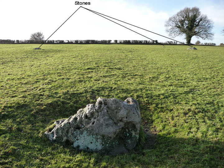
Looking SW from the most upright of the stones at the “official” site. Three prostrate stones can just be made out where indicated. The modern sarsen at the road junction just sneaks into view on the extreme right.

Looking NE across the “official” site of the circle. The Marlborough Downs rise on the right.

For Rhiannon, one of the enormous shake holes near Eglwys Faen. Wonder what the cairn builders made of these huge entrances into the earth? Looking towards the summit of Twr Pen-cyrn.

The cairn group, seen from the west.