Skip to content
Julian Cope
presents
The Modern
Antiquarian
Latest
Posts
Sites
Map
Blog
Forum
search
Search
⚠️
Sign in
more_horiz
United Kingdom
Scotland
Highland (Mainland)
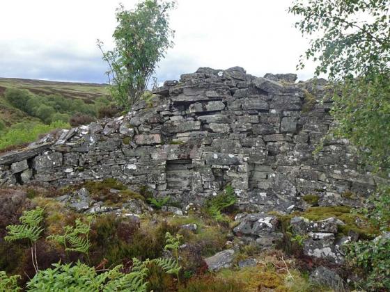
Feranach
Broch
NC844273
expand_more
Nearest town:
Dornoch (38km S)
OS reference:
NC844273
OS sheet:
17
Latitude:
58° 13' 9.89 N
Longitude:
3° 58' 5.22 W
Added to TMA by
Lianachan
Images (1)
Add
content
Images
Image credit: Lianachan
L
Lianachan
Apr 2, 2008
Sites within 20km of
Feranach
Kinbrace Burn
Chambered Cairn
•
3.31km ENE
photo
4
description
3
Kinbrace Hill
Chambered Cairn
•
3.32km ENE
photo
21
description
1
Altanduin
Broch
•
3.63km WSW
Creag Nan Caorach, Kinbrace
Chambered Cairn
•
4.4km NE
photo
9
description
1
Harvieston
Ancient Village / Settlement / Misc. Earthwork
•
4.42km NNW
photo
8
description
1
Suisgill
Broch
•
4.73km E
photo
13
description
1
Carn Richard
Chambered Cairn
•
4.95km NW
photo
14
description
1
Ach'na H-uai'
Cairn(s)
•
5.18km NW
photo
2
Kinbrace
Multiple Stone Rows / Avenue
•
5.18km NW
photo
4
description
1
Carn Nam Buth
Broch
•
5.94km E
photo
6
description
1
Learable Hill
Cup and Ring Marks / Rock Art
•
5.99km E
photo
5
description
1
Learable Hill
Stone Circle
•
6.06km E
photo
3
description
1
Learable Hill
Stone Row / Alignment
•
6.16km E
photo
15
description
4
Ach An Fhionnfhuraidh
Broch
•
6.65km E
Suisgill Lodge
Souterrain
•
7.14km E
description
1
Carn Glas, Badanloch Hill
Kerbed Cairn
•
8.71km WNW
photo
9
description
1
Clach Na H-Uaighe
Standing Stone / Menhir
•
9.08km ESE
photo
1
Cnoc Molach, Badanloch Forest
Stone Row / Alignment
•
9.95km WNW
photo
16
description
2
Carn Liath, Strath of Kildonan
Cairn(s)
•
10.08km ESE
photo
5
description
1
Craig Halligarry
Cup and Ring Marks / Rock Art
•
10.61km ESE
photo
5
description
2
link
1
Cnoc Bad A’ Ghille Dhuibh
Cairn(s)
•
10.67km WNW
photo
5
description
1
Kilearnan
Broch
•
11.42km ESE
photo
9
description
1
Kilearnan Hill
Broch
•
11.98km ESE
photo
1
The Craggan
Cairn(s)
•
12.11km ESE
photo
3
Balvalaich
Broch
•
13.03km E
photo
6
description
1
Ben Uarie
Cairn(s)
•
13.74km ESE
photo
16
description
2
Ben Griam Beg
Hillfort
•
13.83km NNW
photo
19
description
2
Gailiable
Broch
•
13.85km ESE
photo
3
description
1
Strath of Kildonan
Stone Row / Alignment
•
14.09km E
photo
2
description
2
Torrish Burn
Multiple Stone Rows / Avenue
•
14.66km E
photo
4
description
1
Caisteal na Coille
Broch
•
14.76km SSW
photo
16
description
1
Leathad An Daraich
Standing Stone / Menhir
•
14.78km W
photo
1
Loch Rimsdale
Multiple Stone Rows / Avenue
•
14.81km W
photo
4
description
1
Torrish Burn
Kerbed Cairn
•
14.99km E
photo
7
description
1
Clach Mhic Mhios, Glen Loth
Standing Stone / Menhir
•
15.56km ESE
photo
20
forum
1
description
4
Eldrable
Broch
•
16.56km E
photo
1
Allt Preas Bhealaich
Ancient Village / Settlement / Misc. Earthwork
•
16.84km ENE
photo
2
description
1
Kilphedir
Broch
•
17.13km E
photo
13
description
3
Glen Loth
Standing Stones
•
17.18km ESE
photo
8
description
2
Kilphedir
Chambered Cairn
•
17.36km E
photo
8
description
1
Carn Bran
Broch
•
18.01km ESE
photo
13
forum
1
description
4
link
1
Salscraggie Cairn
Cairn(s)
•
18.19km E
photo
8
description
1
Meall A Choire Bhuidhe
Kerbed Cairn
•
18.71km W
photo
3
description
1
Caen Burn, Strath of Kildonan
Long Cairn
•
19.28km E
photo
33
forum
1
description
2
Lothbeg Bridge
Chambered Cairn
•
19.64km ESE
photo
12
description
1
search
I’m looking for…
location_on
photo
ondemand_video
forum
description
link