Skip to content
Julian Cope
presents
The Modern
Antiquarian
Latest
Posts
Sites
Map
Blog
Forum
search
Search
⚠️
Sign in
more_horiz
Eire
County Meath
Danestown Ringfort
Rath
N977647
expand_more
Nearest town:
Carnew (4km E)
OS reference:
N977647
OS sheet:
43
Latitude:
53° 37' 22.72 N
Longitude:
6° 31' 23.65 W
Added to TMA by
megaman
Images (4)
Add
content
Images
24/9/07
Image credit: ryaner (OPW)
ryaner
Sep 25, 2007
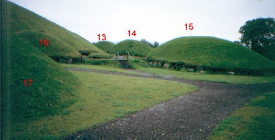
Deep fosse
M
megaman
May 31, 2006
Viewed from the South
M
megaman
May 31, 2006
Worms View
M
megaman
May 31, 2006
Sites within 20km of
Danestown Ringfort
Gerrardstown
Artificial Mound
•
3.61km W
Realtoge
Hillfort
•
4.37km W
photo
3
description
1
Gaulstown
Round Barrow(s)
•
4.44km ENE
photo
2
description
1
Clonardran
Artificial Mound
•
5.08km WSW
Rath Lugh
Rath
•
5.08km SW
photo
3
forum
2
description
1
Lismullin
Timber Circle
•
5.26km SW
photo
5
description
2
link
1
Garlagh
Artificial Mound
•
5.48km WSW
Collierstown
Barrow / Cairn Cemetery
•
5.62km SSW
Blundelstown
Artificial Mound
•
5.89km WSW
Painestown
Artificial Mound
•
5.99km NW
Boolies Great
Artificial Mound
•
6.57km E
Kingstown & Carnuff Great
Cairn(s)
•
6.73km WNW
photo
1
Cabragh
Artificial Mound
•
6.77km SW
Rossnaree
Artificial Mound
•
7.2km N
photo
2
description
1
Johnstown
Artificial Mound
•
7.34km NNW
The Banqueting Hall
Enclosure
•
7.37km SW
photo
8
description
2
Roadmain
Artificial Mound
•
7.44km ESE
The Sloping Trenches
Barrow / Cairn Cemetery
•
7.46km SW
photo
3
Grainne’s Enclosure
Hillfort
•
7.46km SW
photo
7
Churchyard Stones
Standing Stones
•
7.48km SW
photo
8
description
3
Longford
Artificial Mound
•
7.54km NE
The Barrows
Barrow / Cairn Cemetery
•
7.63km SW
Rath of Synods
Rath
•
7.63km SW
photo
5
description
2
The Royal Enclosure
Henge
•
7.7km SW
photo
1
description
1
Cormac’s House
Hillfort
•
7.7km SW
photo
7
description
2
The Mound of Hostages
Passage Grave
•
7.7km SW
photo
25
forum
2
description
3
The King’s Seat
Round Barrow(s)
•
7.7km SW
photo
9
description
3
Lia Fail
Standing Stone / Menhir
•
7.7km SW
photo
13
forum
1
description
7
link
1
Rath Laoghaire
Rath
•
7.77km SW
photo
2
forum
1
Piercetown
Artificial Mound
•
8.08km ESE
Windmill Hill
Henge
•
8.22km ESE
Balgeeth
Artificial Mound
•
8.34km E
photo
1
link
1
Rath Maeve
Henge
•
8.35km SW
photo
8
description
3
Kilbrew
Henge
•
8.37km SE
photo
2
description
1
Newgrange Tumulus B
Passage Grave
•
8.43km NNE
photo
2
description
1
Newgrange Tumulus A
Passage Grave
•
8.44km NNE
photo
2
description
1
Newgrange K & L
Passage Grave
•
8.46km NNE
photo
9
description
1
Newgrange Standing Stone C
Standing Stone / Menhir
•
8.49km NNE
photo
5
forum
1
description
1
The Great Circle
Stone Circle
•
8.49km NNE
photo
16
description
1
Newgrange
Passage Grave
•
8.56km NNE
photo
86
forum
26
description
26
link
14
Moorepark
Artificial Mound
•
8.57km E
Newgrange Cursus
Cursus
•
8.6km NNE
photo
2
Primatestown
Artificial Mound
•
8.61km ESE
Hedgerow Stone
Standing Stones
•
8.7km NNE
photo
2
forum
1
Knowth
8.93km N
photo
107
forum
9
description
9
link
3
Trevet
Artificial Mound
•
9.12km S
photo
3
Gallows Hill
Hillfort
•
9.53km NNW
Bellewstown
Artificial Mound
•
9.58km ENE
photo
3
description
2
Ardsallagh
Bullaun Stone
•
9.59km WSW
photo
2
Dowth Mound II
Artificial Mound
•
9.59km NNE
Dowth Mound III
Artificial Mound
•
9.68km NNE
Stanley Hill
Hillfort
•
9.73km NNW
Newtown
Artificial Mound
•
10.16km ESE
Dowth I
Passage Grave
•
10.17km NNE
photo
61
ondemand_video
1
description
3
link
2
Dowth
10.18km NNE
forum
2
description
2
link
2
Hill of Slane Souterrain
Souterrain
•
10.34km NNW
Hilltown Little
Round Barrow(s)
•
10.36km ENE
Hill of Slane Barrow
Round Barrow(s)
•
10.52km NNW
link
1
Dowth II
Passage Grave
•
10.59km NE
ondemand_video
1
Dowth Mound I
Artificial Mound
•
10.68km NE
Monknewtown Pond
Enclosure
•
10.92km NNE
photo
3
description
1
Dowth Henge
Henge
•
11.05km NE
photo
9
description
1
Monknewtown
Henge
•
11.16km NNE
photo
2
Monknewtown II
Passage Grave
•
11.22km NNE
photo
2
description
1
Dunsany
Bullaun Stone
•
11.29km SW
photo
3
description
1
Gernonstown
Artificial Mound
•
11.31km NW
photo
1
description
1
Cloghalea
Stone Circle
•
11.36km NE
photo
4
description
2
Garristown
Artificial Mound
•
11.56km ESE
Gernonstown
Round Barrow(s)
•
11.83km NW
photo
4
description
1
Littlegrange
Passage Grave
•
11.9km NNE
photo
7
forum
1
description
1
link
1
Heathtown Henge I
Henge
•
11.91km E
Stackallan
Henge
•
11.92km WNW
photo
2
Cooljohn
12.43km WSW
photo
1
description
1
Townley Hall Souterrain
Souterrain
•
12.64km NNE
Heathtown Henge II
Henge
•
12.65km E
photo
5
Heathtown Mound
Artificial Mound
•
12.66km E
photo
3
description
1
Rathmaiden
Artificial Mound
•
12.68km NNW
Townley Hall Barrow
Round Barrow(s)
•
13.03km NNE
Micknanstown
Henge
•
13.04km E
photo
1
description
1
Mullagha
Standing Stone / Menhir
•
13.05km WNW
photo
5
description
1
Oldbridge
Standing Stones
•
13.17km NE
photo
6
description
1
Davidstown Barrow
Round Barrow(s)
•
13.24km NW
Mooretown
Artificial Mound
•
13.4km SSW
Fourknocks
Passage Grave
•
13.4km E
photo
26
forum
1
description
3
link
2
Knockmark
Artificial Mound
•
13.45km SSW
Greenanstown
Standing Stones
•
13.45km E
photo
2
description
2
Fourknocks
Barrow / Cairn Cemetery
•
13.69km E
photo
4
description
1
Mellifont
Round Barrow(s)
•
13.73km NNE
Herbertstown
Artificial Mound
•
13.79km E
photo
2
description
2
Mullahteelin
Round Barrow(s)
•
14.13km ENE
Bey More
Artificial Mound
•
14.62km ENE
Westown North
Round Barrow(s)
•
15.13km E
photo
1
Culmullin
Artificial Mound
•
15.28km SSW
photo
3
description
1
Hodgetown
Artificial Mound
•
15.3km E
Drogheda
Artificial Mound
•
15.5km NE
Mullagharoy
Cup and Ring Marks / Rock Art
•
15.86km NNW
photo
4
forum
1
Mallahow
Artificial Mound
•
16.31km E
Derrypatrick
Bullaun Stone
•
16.33km SW
photo
3
Tullog
Artificial Mound
•
16.35km E
The Stuck Stone
Standing Stone / Menhir
•
16.35km NNW
forum
2
Damastown
Artificial Mound
•
16.36km E
photo
3
Slieve Beagh
Barrow / Cairn Cemetery
•
16.37km NW
photo
10
description
3
Arch Hall
Cup and Ring Marks / Rock Art
•
17.17km WNW
photo
4
description
2
Rathkenny
Portal Tomb
•
17.4km NW
photo
7
description
1
Kilbride (Talbotstown Lower By.)
Cairn(s)
•
17.92km NNE
photo
6
Iskaroon
Artificial Mound
•
18.01km WSW
photo
3
description
2
Newtown (Navan Upper By.)
Holed Stone
•
18.1km WSW
photo
3
Lismahon
Artificial Mound
•
18.12km S
photo
1
Dunmore
Barrow / Cairn Cemetery
•
18.2km NNW
Kichenstown
Artificial Mound
•
18.3km E
Knockbrack
Hillfort
•
18.34km E
description
1
Knockbrack
Passage Grave
•
18.42km E
Mount Oriel
Barrow / Cairn Cemetery
•
18.58km N
photo
3
Knock
Bullaun Stone
•
18.71km WNW
photo
2
Hollywood Great
Artificial Mound
•
18.89km E
photo
1
Nags Head
Artificial Mound
•
18.89km E
Laytown (An Inse)
Artificial Mound
•
18.91km ENE
photo
5
forum
1
description
1
Rathbran More
Souterrain
•
19.03km NNW
photo
4
description
2
Teltown
Cup and Ring Marks / Rock Art
•
19.08km W
photo
1
Fieldstown
Cairn(s)
•
19.08km NE
photo
5
description
2
Belpatrick
Artificial Mound
•
19.14km NNW
Paddock
Wedge Tomb
•
19.76km NNE
photo
13
description
2
search
I’m looking for…
location_on
photo
ondemand_video
forum
description
link