Skip to content
Julian Cope
presents
The Modern
Antiquarian
Latest
Posts
Sites
Map
Blog
Forum
search
Search
⚠️
Sign in
more_horiz
Eire
County Meath
Teltown
Cup and Ring Marks / Rock Art
N804729
expand_more
Nearest town:
Navan (8km ESE)
OS reference:
N804729
OS sheet:
42
Latitude:
53° 41' 58.5 N
Longitude:
6° 46' 57.14 W
Added to TMA by
CianMcLiam
Images (1)
Add
content
Images
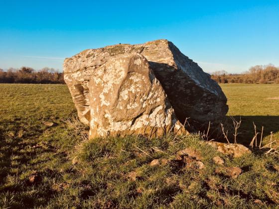
Image credit: Ken Williams/ShadowsandStone.com 2008
CianMcLiam
Mar 9, 2008
Sites within 20km of
Teltown
Arch Hall
Cup and Ring Marks / Rock Art
•
4.07km ENE
photo
4
description
2
Mullaghey
Standing Stone / Menhir
•
7.13km WNW
photo
4
description
1
Staholmog
Standing Stones
•
8.54km NNW
description
1
Mullagha
Standing Stone / Menhir
•
9.28km ENE
photo
5
description
1
Knock
Bullaun Stone
•
9.74km NE
photo
2
Stackallan
Henge
•
9.82km ENE
photo
2
Rathkenny
Portal Tomb
•
10.77km NE
photo
7
description
1
Iskaroon
Artificial Mound
•
11.39km S
photo
3
description
2
Ardsallagh
Bullaun Stone
•
11.74km ESE
photo
2
Gernonstown
Round Barrow(s)
•
12.41km ENE
photo
4
description
1
Tullaghanoge
Rath
•
12.64km SSW
photo
2
Kingstown & Carnuff Great
Cairn(s)
•
12.67km E
photo
1
Gernonstown
Artificial Mound
•
12.94km ENE
photo
1
description
1
Wardstown
Rath
•
12.99km SW
photo
8
description
3
link
1
Davidstown Barrow
Round Barrow(s)
•
13.23km ENE
Balnagon Upper stone pair
Standing Stones
•
13.25km W
photo
3
description
1
Nobberbeg
Bullaun Stone
•
14.5km N
photo
5
forum
1
description
1
Realtoge
Hillfort
•
14.71km E
photo
3
description
1
Slieve Beagh
Barrow / Cairn Cemetery
•
14.92km ENE
photo
10
description
3
Painestown
Artificial Mound
•
15.08km E
Cooljohn
15.19km SE
photo
1
description
1
Clonardran
Artificial Mound
•
15.63km ESE
Hill of Slane Barrow
Round Barrow(s)
•
15.69km ENE
link
1
Gerrardstown
Artificial Mound
•
15.71km E
Johnstown
Artificial Mound
•
15.77km E
Newtown (Navan Upper By.)
Holed Stone
•
16km SSE
photo
3
Mullagharoy
Cup and Ring Marks / Rock Art
•
16.04km ENE
photo
4
forum
1
Garlagh
Artificial Mound
•
16.12km ESE
Rathmaiden
Artificial Mound
•
16.24km ENE
Hill of Slane Souterrain
Souterrain
•
16.27km ENE
The Stuck Stone
Standing Stone / Menhir
•
16.28km ENE
forum
2
Gallows Hill
Hillfort
•
16.39km ENE
Stanley Hill
Hillfort
•
16.4km ENE
Galboystown
Rath
•
16.55km WSW
photo
1
Rathbran More
Souterrain
•
16.67km NE
photo
4
description
2
Eden
Bullaun Stone
•
16.8km NNW
photo
3
description
1
Blundelstown
Artificial Mound
•
16.86km ESE
The Sloping Trenches
Barrow / Cairn Cemetery
•
17.1km ESE
photo
3
Grainne’s Enclosure
Hillfort
•
17.1km ESE
photo
7
The Banqueting Hall
Enclosure
•
17.3km ESE
photo
8
description
2
Lismullin
Timber Circle
•
17.32km ESE
photo
5
description
2
link
1
The Barrows
Barrow / Cairn Cemetery
•
17.46km ESE
Rath of Synods
Rath
•
17.46km ESE
photo
5
description
2
The Royal Enclosure
Henge
•
17.54km ESE
photo
1
description
1
Lia Fail
Standing Stone / Menhir
•
17.54km ESE
photo
13
forum
1
description
7
link
1
The King’s Seat
Round Barrow(s)
•
17.54km ESE
photo
9
description
3
The Mound of Hostages
Passage Grave
•
17.54km ESE
photo
25
forum
2
description
3
Cormac’s House
Hillfort
•
17.54km ESE
photo
7
description
2
Churchyard Stones
Standing Stones
•
17.59km ESE
photo
8
description
3
Rath Laoghaire
Rath
•
17.61km ESE
photo
2
forum
1
Rossnaree
Artificial Mound
•
17.66km E
photo
2
description
1
Rath Lugh
Rath
•
17.75km ESE
photo
3
forum
2
description
1
Cabragh
Artificial Mound
•
17.84km ESE
Clonasillagh
Passage Grave
•
17.96km W
photo
5
description
1
Clonasillagh Decorated Stone
Cup and Ring Marks / Rock Art
•
18.11km W
photo
3
description
2
Clonasillagh Cairn
Cairn(s)
•
18.15km W
photo
3
description
2
King’s Mountain
Standing Stone / Menhir
•
18.26km W
photo
8
forum
1
description
3
Killeter Hill
Court Tomb
•
18.39km WNW
photo
2
description
1
Bobsville
Cup Marked Stone
•
18.79km W
photo
7
forum
1
description
1
Rath Maeve
Henge
•
18.79km ESE
photo
8
description
3
Belpatrick
Artificial Mound
•
18.97km ENE
Dunmore
Barrow / Cairn Cemetery
•
18.97km ENE
Danestown Ringfort
Rath
•
19.08km E
photo
4
Knowth
19.16km ENE
photo
107
forum
9
description
9
link
3
White Mountain
Barrow / Cairn Cemetery
•
19.2km NE
Stirrupstown
Rath
•
19.37km WSW
photo
2
Thomastown
Passage Grave
•
19.64km W
photo
6
description
2
Edengora
Wedge Tomb
•
19.89km NW
photo
10
Collierstown
Barrow / Cairn Cemetery
•
19.91km ESE
search
I’m looking for…
location_on
photo
ondemand_video
forum
description
link