
The Cynon valley from Carn Pentyle Hir.
Image credit: A. Brookes (21.11.2015)
The Cynon valley from Carn Pentyle Hir.

Biggish slab on the top of Carn Pentyle Hir. The snow made any further investigation difficult.

Looking southeast across Carn Pentyle Hir. There are further cairns and a hillfort on the ridge to the right.

Carn Pentyle Hir from the southwest.

There are a number of upright stones around the edge of the cairn, which might suggest a kerb, but they’re not earthfast and are just as likely to be clearance stones added later.
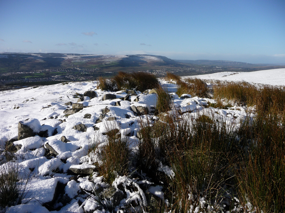
Carn Pentyle Hir, the most substantial of the cairns on Mynydd Aberdare, overlooking the Cynon valley.

And looking over Cistfaen towards Merthyr Common across the Taff valley.

Looking across Cistfaen cairn towards Rhos Gwawr on the other side of the Cynon valley.

Slab on top of Cistfaen cairn, presumably removed from the central cist that gave the cairn its name.

Looking down the Taff valley from Carn Tyle Hir. Further cairns are situated along the ridge on the right.

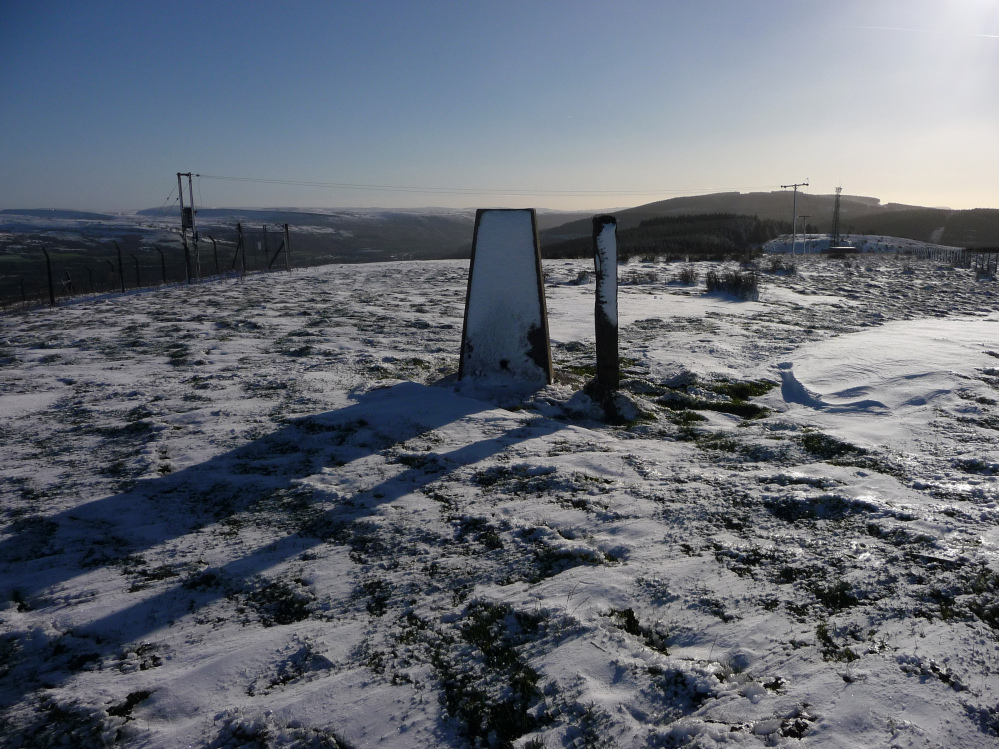
the possible Carn Tyle Hir cairn, a slight mound underneath the trig pillar.

Carn Tyle Hir is on the summit of the hill. The cairn here is uncertain, but the views across towards Fforest Fawr and the Brecon Beacons are terrific. It certainly wouldn’t be an unusual site for a Bronze Age cairn.
Visited 21.8.13
Directions:
Head for Heolgerrig, west of Merthyr Tydfil, off the A470.
Travel through the village and head up the narrow and very steep lane (towards the antennae).
Park next to the transmitter station – at this point the tarmac pretty much ends.
It was with some relief I actually managed to drive to the top of this hill. My poor car ‘old faithful’ had to be put into 1st gear it was so steep. The sight you are confronted with at the top of the hill is awful – fly-tipping everywhere. The road was actually blocked by two old mattresses. Kitchen units, torn open black rubbish bags, vacuum cleaners, toys, litter of all description was dumped in various piles all around. I have said it before and I will say it again, in all my travels around the country there is nowhere and I mean nowhere which comes close to the filth you find at South Wales Valleys sites. There is clearly something which is in the psyche of some of the people who live in this area which makes them think that fly-tipping is ok? Well, if you happen to be reading this (which I very much doubt) it isn’t. You and your sort are a disgrace to humankind. I am not happy.
Rant over; I will now move onto the subject in question i.e. the Cairn on Mynydd Aberdare.
This site had been on my ‘hit list’ for a long time and I was pleased to have finally got here.
I jumped over the metal gate at the bottom of the transmitter station and walked up the track. At the back of the station I jumped over the double barbed wire fence and managed to cut my knee of the barbed wire. You cannot see the Cairn from here but the trick is to look west for an old wooden post. Once you reach the post the Cairn can be seen, a short distance to the north. In total a 5 minute walk from the car.
The Cairn is pretty good actually. It is a large pile of grey stones (guarded by sheep) and occupies a prominent position with extensive views. I couldn’t see any sign of the cist. It looks as though it must have been covered over to protect it?
I sat a while and imagined the rubbish gone, the houses had not been built and how the area must have looked when the Cairn was first built. This would have been a nice spot. Before long low, black, threatening rain clouds started to blow in over the horizon – time to move on.
On the way back I walked outside of the transmitter station and was pleased to see there was a gate I could hop over back to the road. No need to risk my legs again!
All in all this is a good Cairn to visit, despite the disgraceful surroundings.
There is more than one Bronze Age cairn on the top of the mountain here, and flint arrowheads have been found in the area in the past. Perhaps these things helped contribute to the development of the following story, told by Wirt Sikes in ‘British Goblins’ (1880):
There is a tradition among the Glamorgan peasantry of a fairy battle fought on the mountain between Merthyr and Aberdare, in which the pygmy combatants were on horseback. There appeared to be two armies, one of which was mounted on milk-white steeds, and the other on horses of jet-black. They rode at each other with the utmost fury, and their swords could be seen flashing in the air like so many penknife blades. The army on the white horses won the day, and drove the black-mounted force from the field. The whole scene then disappeared in a light mist.
Unusual to have fairies with steel blades – perhaps they were flint really. Flint arrowheads have been widely interpreted as ‘elf shot’. A spring is very close to one of the cairns; it is called ‘Ffynnon y Gro’ (spring of gravel? – or perhaps it was ‘Croyw’ in the past, which would mean fresh/sweet water?).
There are actually three cairns up here, or at least two definites and a possible. The possible cairn at the summit of the hill is not shown on the OS 1/25000, but has terrific views of Fforest Fawr, the Brecon Beacons and the hills above the Taff valley.
From GGAT, north-south:
Carn Tyle Hir (SO02060558)
RCAHMW did not include it in the inventory as the remains were so insubstantial, and it was therefore not included in the field visit list. However, it could be seen when the two other sites in this group, PRNs 445m and 459m, on the adjoining property, were visited, appearing as a slight platform immediately under the trig point, preserved on its N and E sides, and about 0.2m high; though it is possible that this earthwork is entirely due to the trig point foundations.Cistfaen (SO0217505345)
A slight grass-covered mound with a very large hole (2.3m E-W x 1.5m and c0.7m deep) dug into the top. A couple of blocks of sandstone (up to 0.7m) can be seen on the surface, with more slabs and small blocks in the central hole. In 1959 RCAHMW noted four slabs each about 0.9m by 0.6m, lying on the surface, evidently the remains of the cist. Dimensions: 6.6m N-S x 6.2m, c0.7m high.Carn Pentyle Hir (SO0196905271)
A loose heap of blocks, slabs and boulders up to 0.6m across, mainly of sandstone and some quartzite; partly grass-covered. It is no longer possible to distinguish the kerbing and possible remains of the cist noted by RCAHMW in 1966, although a couple of large slabs up to 0.7m across can be seen in the middle and may represent the remains of the cist. It is situated on a very marked false crest at the top of a very steep hillside. Dimensions: 7.6m diameter, c0.6m high.


