Image Credit: Environment Agency copyright and/or database right 2015.
Image credit: Open Source Environment Agency LIDAR
Image Credit: Environment Agency copyright and/or database right 2015.

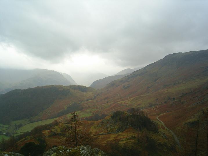
Looking towards Derwent Water... and where Skiddaw would be if it wasn’t for that mass of customary Cumbrian vapour

Looking along the River Derwent towards Rosthwaite from the hillfort....


The very top of Castle Crag

The view from just below the summit of Castle Crag

Castle Crag Iron Age hillfort, viewed from Nitting Haws, looking SE 21/08/09.

Castle Crag Iron Age hillfort, centre, viewed looking S from above Borrowdale Gates 21/08/09.

23/12/05 Castle Crag hillfort from the north, on the descent to Grange, as the fingers of night creep up on the Borrowdale valley. The last rites of one of those dark days at the sad tail-end of the year.

23/12/05 Looking back southwards to Castle Crag hillfort, showing the west face in profile.

23/12/05 The west face of Castle Crag hillfort rearing up in a mass of Borrowdale volcanic rock.

23/12/05 The west face of Castle Crag hillfort rising up in a mass of scree and rock to the larch-girdled summit and sky.

23/12/05 The west face of Castle Crag hillfort, impregnable on this side to any attack.

23/12/05 Castle Crag hillfort from the south ridge, with Derwent Water behind.

23/12/05 Castle Crag hillfort from the southern approach, below Low Scawdel, with the larch showing against the sky. Derwent Water lies beyond.

23/12/05 Looking south down Borrowdale to Castle Crag hillfort, from the eastern slopes of Catbells.

Castle Crag hillfort from the south. Taken from Grains Gill above Seathwaite.

Castle Crag hillfort looking SE.
Castle Crag hillfort looking S.

Looking E from Castle Crag hillfort, showing the low bank.

Looking NE from Castle Crag hillfort, with low bank.

View from Grange in Borrowdale, looking south to Castle Crag, in the centre. The hillfort is on the summit of the central fell.
Visited Sunday 22nd May 2011
Very interesting to read the field notes by The Eternal and Gladman on this one as I had no idea it came into the category of hillfort. We walked up to the top of Castle Crag on a damp morning, the first day of a week’s walking holiday in the Lake District. A lovely and relatively easy walk from where we were staying in the village of Grange; after a night of heavy rain the woodland streams tumbled downhill over their stoney beds into the river Derwent.
We saw no one until we started to ascend the hill, then dozens of people (and their dog) appeared making their way downhill from the summit – our first hint that the more popular footpaths in the Lake District can become quite busy, especially at weekends. Marvellous views towards Skiddaw on one side and over the Borrowdale valley on the other.
The top of the hill is a narrow track up through what looks like a slate mound – I didn’t do this bit as was still finding my feet and to me it looked slippery. My holiday companion went enthusiastically to the top and reported jagged slate rocks sticking up in castellations.
Later in the week I climbed the very little mountain of Cat Bells, also walked up Great End Crag at the Great Gable side of Seathwaite Fell (2000ft) so Castle Crag was a great way to start.
Although very popular with the tourists and with scant traces of defences visible upon the summit plateau – to the layman such as myself, anyway – this hillfort is still very much worth a visit simply because of the superb views up and down Borrowdale to Derwentwater, Skiddaw etc
I would say you’re best to stick to the main track since I ended up at a dead-end ‘round the back [Low Hows Wood-way] and faced a vertical ascent through trees. Serves me right for trying to avoid the quarry and for being flash.
Castle Crag is a great place to come when low cloud obscures the major summits around and about, with a pleasant walk by the river to get there from Rosthwaite, too. Note, however, that the National Trust holds Borrowdale in a vice-like grip, so if you come by car, either be prepared to park outside the town (if you can) and walk in, or pay an extortionate fee. Now I accept the need for proper maintenance and conservation as much as the next man... but this is out of order. Catering for the wealthy only.
Visited September 2008
The only visible remains of this supposed Iron Age univallate hillfort are the low bank and part of a shallow ditch. What a spectacular site for a hillfort. I doubt anywhere compares to this. To the S a 19th Century quarry bites into the site.
The summit area is small, and the population must have numbered few.
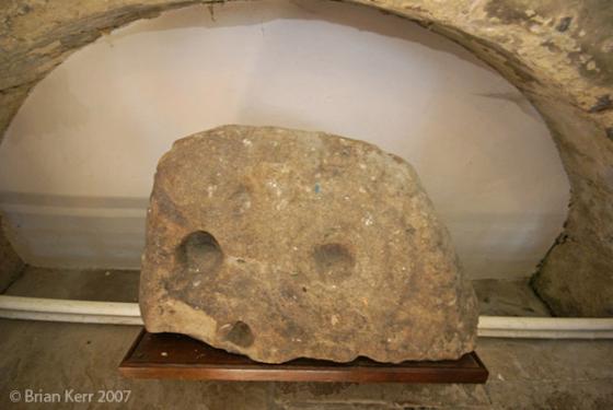
“Earthwork remains of a slight Iron Age? univallate hillfort; antiquarian work recovered Roman pottery and evidence for iron working on the site.” (Quote from PastScape).
I’ve visited this site many times and in many different weathers. It’s a windswept site, with mountains rising all around, but it commands views down to all points of the compass.
The old track through the valley and over Sty Head Pass to the S, finally to the sea, passes below.
It is an impregnable place, the ground falling away precipitously to the N, E and W. To the S there is access, though very steep, making the hillfort well defended. The bank and ditch are unnecessary to the N, E and W. Here there are vertical drops.
A modern aspect is the war memorial, on the summit, a slate slab inscribed to the the men of Borrowdale who gave the ultimate sacrifice during the Second World War, mounted on the crowning rock. What finer memorial could they have?