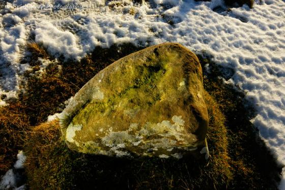
Apparently it’s a 43x54m oval, with an entrance to the north, but only 60cm banks. The pdf is the EH RSM file from the Magic map.
Articles
Sites within 20km of Tone Hall
-
Lowshield Green
-

Pitland Hills
photo 2description 3link 4 -
Devil’s Stone (Birtley)
description 2 -

Hawick (Bavington)
photo 6description 1link 1 -

Warkshaugh Farm
photo 2description 1link 2 -

Swinburne Terraces
photo 2description 4 -

Great Swinburne
photo 7description 3 -
Nunwick Park
description 1 -

Ray-Sunnyside
photo 17description 1link 1 -
Woodhouse
description 1 -

Fenwick Fell Field
photo 8description 1link 2 -
The Goatstones
photo 31description 5link 1 -

Carr Hill
photo 12description 1link 3 -

Tod Crag, Ottercops Moss
photo 18forum 1description 2link 1 -

Homer’s Lane
photo 1description 1link 1 -

Grindstone Law
photo 1description 1 -
Warden Law
photo 4description 2 -

Howden Hill (Northumberland)
photo 12description 1link 2 -

Davy’s Lee
photo 4description 1 -

Wallington Hall
photo 4forum 1description 2 -

Paine’s Bridge
photo 5description 1link 2 -

Haughton Common
photo 16description 3link 2 -

Warden Mound
photo 1description 1 -

Whitley Pike
photo 10forum 1description 1 -

West Shaftoe
photo 4description 1link 1 -

King Wanless Green
photo 5description 1 -

Kings Crag Cairn
photo 6 -

Camp Hill (Otterburn)
photo 1description 1link 1 -

Fawdon Hill
photo 2description 2 -

Kingscrag Gate
photo 20forum 1description 2 -

Middleton
photo 6description 3 -

Piper’s Chair
photo 7description 4 -

The Warrior Stone
photo 26forum 1description 4 -

St John Lee
photo 4description 1link 1 -

Hallion’s Rock
photo 4description 2 -

Salter’s Nick
photo 5description 5 -
Matfen Barrow
description 1 -

Middleton Bank Top
photo 9description 1link 1 -

The Matfen Stone
photo 21forum 1description 7 -

The Poind And His Man
photo 14forum 1description 4 -
The Black Dyke
link 1 -

Beggarbog
photo 3description 2 -

Ridley Common
photo 16forum 1description 2link 2 -

Bygate Hill
photo 15description 2 -

Corbridge
photo 4description 2link 2 -

Shortflatt Tower
photo 4description 1 -
Bantam Hill
-

Shortflatt
photo 4description 1 -

Fallowlees Burn
photo 8description 2 -

Fontburn Reservoir
photo 5description 2 -

Shindon Hill
photo 5description 1 -

Greenlee Lough
photo 4forum 1description 1 -

Fontburn (b)
photo 20forum 1description 3 -

Fontburn Dod Wood
photo 31description 3link 1 -

Thornborough Portable
photo 7forum 3description 2link 1 -

Bolam Cairn
photo 2description 1 -

Brigantium
photo 4description 4link 1 -

Roughlees
photo 2description 1