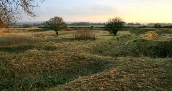
Grim’s ditch as it moves westward towards Bokerley dyke.
Image credit: Mike Rowland 17/09/2007.
Grim’s ditch as it moves westward towards Bokerley dyke.


Couldn’t see this at first as the approach to the top of this bare and almost flat topped ridge hides it from view. Once there however it’s quite rewarding, a sinuous ditch with banks in places, sometimes climbing gently up the hill or following the contours where the ditch becomes a flat path with the natural steepness of the hill on one side and a smaller bank accentuating the drop on the other. From looking at this very short section it’s impossible to say whether it was built to keep raiders out, stock in or a huge statement of property ownership. Was it pallisaded? It seems unlikely as maintenance and patrol of this vast ranch boundary would tax even a modern stock farmer.
(“Soldiers Ring” ESE, marked by a prominent clump of trees, is Roman)
Disabled: Parking available up a cobbled road, right next to a gate. Gentle slope on grazed turf to top from where some of the ditch can be seen. Extensive views.
This is but a very short section of the remains of a massive earthwork which encloses much of this part of Hampshire. The County boundary still follows the course of this dyke (although not here) which gives western Hampshire a huge penninsular of land which juts into Wiltshire and Dorset. Part of the W boundary is defined by the Bokerley Dyke and a short stretch by a Roman road. Much of the Dyke consists of twin banks with a ditch between. The area enclosed is about 16 sq.miles in extent and deliniates a large ranch belonging to the Middle/Late Bronze Age.
Details of site on Pastscape
The Grim’s Ditch on Cranborne Chase is a complicated system of bank-and-ditch features, enclosing (by accident or design) an area of approximately 14.5 Sq miles. The various lengths overshoot, digress and leave gaps in places. Field work and excavation c1943 by C M Piggott led to the following conclusions:
a. The system is not a unitary work, but a complex of separate pieces.
b. The pieces were probably nor coeval. The northern and eastern sides were both almost certainly LBA, but the southern side is more likely to have been IA.
c. The features probably represent some form of land division, and are akin to the LBA ‘ranch boundaries’ (Extent on Map strips after Piggott and Sumner) (1)
(17) Grim’s Ditch in the extreme NE of the parish and adjacent to (16), is part of a complex of boundary ditches which extends for nearly nine miles from west to east across Cranborne Chase. Most of the complex lies in Hampshire and it will be described, as a whole in the Inventory of that County; it also continues into the extreme S of Wiltshire. The Dorset section (map opp. p 53 and plate 56) comprises a bank and ditch just over 1.5 miles long, extending NW from Blagdon Hill (SU05551802) in two straight alignments to the vicinity of the Epaulement (SO03741962), the earthwork which projects SW from Bokerley Dyke (16) and represents part of an early phase in the development of that Monument. For much of its length the Dorset section of Grim’s Ditch has been flattened by ploughing, but where best preserved on Blagdon Hill, it comprises a bank 20ft across and up to 3ft high with a ditch 16ft across and 2ft deep along the NE side. On Blagdon Hill the earthwork turns E and after passing under Bokerley Dyke continues on Tidpit Common Down, but the 300ft length immediately W of the dyke has been levelled. At the NW end ploughing has obliterated the relationship of Grim’s Ditch with Bokerley Dyke and the Epaulement; it is possible that it continued NW on the line later followed by Bokerley Dyke.
The Grim’s Ditch complex almost certainly evolved over a lengthy period, extending from the Bronze Age probably into Romano-British times. As yet, however, only the stretch on Martin Down (SU045201), just across the county boundary with Hampshire, has been satisfactorily dated; a length of 300ft was excavated by Pitt-Rivers and found to be of the Bronze Age (Pitt-Rivers, Excavations 1V 190). This complex of boundary ditches is no more than part of a former system of land allotment and utilisation, into which adjacent hill-forts, settlements, ‘Celtic’ fields and also barrows were integrated (2)
SU05651802-SU09441894; SU11601894-SU14532407; SU05162203 – SU14262320; SU03981930 – SU05551803. Grim’s Ditch [NR] (3)
The term ‘Grim’s Ditch’ is a folkname. The term ‘Grim’ is Saxon and is equatable with ‘woden’ which by a process of christian association explains why ‘Devil’s Ditch’ was the countryman’s name. Sumner describes Grim’s ditch as a ‘continuous earthwork... across the eastern portion of Cranborne Chase. The length of its course is about fourteen miles’. However, this is misleading as there are considerable diversities in the plan.
A weak case could be made for the whole being a stock enclosure with the ditch conventionally facing inwards and the linear west from Rentridge (16) A to West Woodyates might form a ‘funnel’ through which deer could be driven. These ditches may have been to do with stock control but it is known that they had origins at varying dates, experienced different stages, and certainly manifested diverse physical forms. However the shallow ditch of Pentridge (17) and the large sections of Martin (80) on Knoll Down or Damerham Ridge indicate a considerable diversity of size. The great variations in size and form on continuous runs are indeed very difficult to rationalise. The dating of all these features is uncertain and, as with the inextricably involved strands of the Bokerley Line, it has to be asked again whether or when all the pieces functioned as a whole (4)
SU03102090- SU04102088 – SU04502136
Section of Grim’s Ditch and associated earthwork scheduled 25608 (5)
SU 05641801 – SU 07351829. Section of Grim’s Ditch, running eastwards along a ridge from Bokerley Dyke on Blagdon Hill. Scheduled. (6)