After the brilliance of Mitchell’s Fold, I head south across the border into Wales with the sun high overhead (8.4.2011). The approach from the north is along a narrow lane heading due south off the minor road between White Grit and Priest Weston (which has a pub). Where the road kinks southwestwards, there are extensive views into Wales to the right, and a stile giving access to the hill on the left.
The trees that used to cover a wedge of hillside on the NW have been felled, leaving an expanse of tree stumps reminiscent of a WW1 Paul Nash landscape. It’s a steep climb up the hill from this side (well, from any side really) but the views more than reward the effort.
Corndon II sits on the highest point of the hill, which it shares with a trig point and a bench (occupied when I arrive, sweaty and staggering, at the summit). There is a fairly large modern-looking cairn, but it is not clear what is the original monument and what isn’t. The whole sits on a natural mound, making it even less obvious. But back to the surroundings.
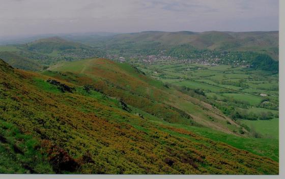
To the north, the views take in Mitchell’s Fold and (just) The Hoarstones circles, as well as Stapeley Hill. Further away NNW are the Berwyn mountains. Much nearer to the east is the long rocky ridge of the Stiperstones, as well as the impressively large Corndon III cairn, which will be my next objective. Peeking over the top of the Long Mynd, the summits of Brown Clee and Titterstone Clee are visible. Much further away to the SE, the Malverns can just about be seen, a signpost back to my home. The mountains of Radnor Forest (near Four Stones circle) block some of the views south, but not enough to obscure the Black Mountains escarpment. Over to the west, Pumlumon and then Cader Idris fade into the blue, and various other ranges of Southern Snowdonia (Arans, possibly the Rhinogs) complete this immense panorama, which has me grinning broadly at the immensity of it all.
A perfect place to sit and get your breathe back after the steep climb, although the lack of an ice cream vendor was disappointing on such a summery day.
I head eastwards along the ridge, towards Corndon III.
After the steep climb up to Corndon II, Corndon III is easily reached by a short stroll along the grassy ridge. Of all the cairns on the hill, this must be the biggest, over 20m across. It has been disturbed, inevitably, but nevertheless remains a really impressive monument. It gives a good idea of what the hilltop cairns of Shropshire, like the ruined ones on Titterstone Clee, would have been like in their prime.
The views, as at II, are extensive.
A few paces away from Corndon III, Corndon IV is certainly not the biggest monument on the hill, but may be the most interesting.
It appears to be a kerb cairn, with a kerb of low boulders encircling the central mound. The kerb is incomplete, but sufficient remains to get a good idea of it. According to Coflein, there was also a central cist, but apart from the usual central scoop, I didn’t notice this on my visit (or its displaced capstone), although it is still visible in the pictures taken. The central space appears to have been further disturbed since Baza’s picture.
From here, my route is SW down the slope to Corndon I. It is not on access land, but a permissive footpath, with a stile, gives access over the fence into the field where it sits.
Much more ruined than II, III and IV, this cairn is a fair size but has been reduced to little more than a low, dense scatter of stones. Terrific views to the west though. The woodland that originally stood on the slope above the cairn has been felled, clearing the view to the NW as well.
Corndon VIII is close by to the SE. It is not on Coflein, nor is it marked on the 1/25000 OS map, which shows Corndon I. This was therefore a bonus on my visit.
A 100 yards or so to the SE of Corndon I, this cairn is circular setting of rubble, surrounding a grassy space. The surrounding cairns are all visible from here, as is the small hillfort on Roundton to the southwest.
From Corndon VIII, I head SE directly towards Corndon V. On route, I pass a small roughly circular mound of earthfast stones protruding from the grass at approx SO306966 – could this be the remains of another cairn? Probably just natural, but you never know.
Corndon V, like III and I, is a very large cairn with a 20m plus diameter. It has the inevitable shelters and disturbance on its top, but remains impressive. What a hill this is for cairns!
I head SW again, towards Corndon VI, the final cairn of the day. Another whopper of 20m plus across, this cairn perches on the southern summit of the hill, making the drop to the farmland below much more apparent.
The cairn incorporates some very large stones, too big even for the walkers’ shelter dug into the centre to make use of. A great place to stop for a while and watch the world go by (or not), before making the steep descent over the edge to Fishpool and the main road.