
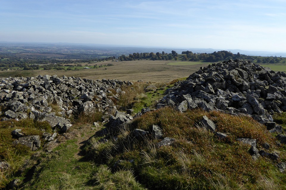
Landscape context of south Shropshire’s hillforts. Seen from Packet Stone, on the Long Mynd to the northwest.
Image credit: A. Brookes (19.11.2022)
Landscape context of south Shropshire’s hillforts. Seen from Packet Stone, on the Long Mynd to the northwest.

Titterstone Clee dominating the surrounding countryside. Seen from Mary Knoll, just west of Ludlow.

An unfamiliar angle on familiar hills: Titterstone Clee is on the far left skyline, Brown Clee to the right. The viewpoint is Walsgrove Hill in the Abberley Hills of Worcestershire, some dozen miles or so to the southeast.

Titterstone Clee under big May clouds, seen from the southwest across the border in Herefordshire.

The southeastern rampart.
Interned banks flank the southeastern entrance.

Looking northwest towards the Long Mynd. The prominent hill on the right skyline is Caer Caradoc above Church Stretton.

Northern rampart.

Looking up towards the Giant’s Chair.

The stone rampart at the northwest of the fort.

The western end of the hill, looking towards Brown Clee. There are no obvious artificial defences here, the naturally steep and rocky slopes presumably deemed enough.
Titterstone Clee from the cairns on Hoar Edge. The two surviving cairns can be seen at the western (left) end of the summit.

Titterstone Clee does its usual impressive job of dominating the countryside for miles around. From fields below Caynham Camp near Ludlow.

Looking up to the rocky outcrop of The Giant’s Chair. The hills of mid-Wales beckon beyond.

The rampart running across the northern slope of the hill. The distant hills far left are the Abberley Hills, across the Teme Valley in Worcestershire, which boast their own hillfort, Woodbury.

Low remains of the southern rampart. Most of the southern side of the fort has been destroyed through quarrying. Not easy to see in the picture, but the Black Mountains (and even Pen y Fan) are visible to the south.

Approaching from the south. The whole of the south side of the hill (and of the fort) has been destroyed by quarrying.

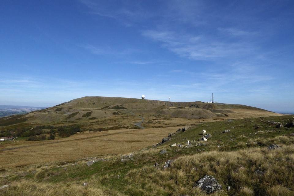
The Titterstone Clee dominates the surrounding landscape and is an instantly recognisable feature. Seen here from Orleton, seven or eight miles to the SSW. The hillfort defences surround the highest part of the hill, enclosing the “golf-ball” of the radar station.
Visited 11 August 2010 via a short bus-ride from Ludlow to Farden and then a walk up to the hill. This is the part of the country I grew up in, the Clee dominating the view from the garden I played in as a kid. The radar station, marked by large white “dinosaur eggs”, was a source of childhood interest from the RAF jets roaring supersonically overhead, trying to get below the radar. I remember coming up here in summer, aged about 9, for a picnic that was memorable only for being so windy that we all stayed in the car. In later years I came up with my Dad, as he tried (largely unsuccessfully) to encourage me to follow in his trials-riding footsteps in steep-sided quarry pits. But it’s been a long time now since I last came here and I’ve never been to look at the hillfort and cairns.
The wind of that far-off picnic isn’t in evidence today, replaced by warm August sunshine and a gentle breeze. Approaching the hill up the road from the SW, the first thing that becomes apparent is the scale of scarring caused to the hill by quarrying. The two cairns are already visible from here, right on the edge of the quarry workings. The line of hillfort ramparts that would have encircled the hill here is gone however. Most of the quarrying itself is now gone, although some smaller scale workings still continue off the hilltop itself away to the south. The quarrying has left the hill as a series of terraces, and it is up these that the road zigzags before reaching a car park and signpost for the Shropshire Way long distance path. This in turn continues as a rougher track up onto the hilltop next to the station. Following the edge of the unnatural cliff round takes me to the two cairns.
The first cairn is a low, flat-topped mound of sizeable diameter but little height. Some stones are visible around its perimeter, perhaps the remains of a kerb. The second cairn, to the NW, is better preserved but has been damaged by an OS trig mounted on its mound. Rather more depressingly, a walker’s shelter of stone blocks has been built into the lee of the cairn. I suspect this has used either material from the cairn itself or from the hillfort rampart, the remaining sections of which are constructed from such blocks. Part of the rampart, escaping destruction by quarrying, can be seen on the slope below the cairn.
The views that have now opened out to the south are extensive, to say the least. The proximity of this place to my childhood has already dug into a buried vein of memories and the way these views link my past to the landscapes of my present, gives me an almost overwhelming sense of euphoria. To the southeast there’s the spine of the Malverns, further south the unmistakable tree-topped May Hill that is visible from so many Cotswold viewpoints, and over to the southwest the Black Mountains’ northern escarpment fills a chunk of the horizon. Most excitingly, just visible as a light blue shape further still to the southwest, are the twin summits of Pen y Fan and Corn Du. The jigsaw of my little world is laid out before me.
Carrying on past the NW cairn, a rocky outcrop at the western end of the hill, known as the Giant’s Chair, forms the highest point (and the third highest in Shropshire at 533m). Looking to the north, the neighbouring Brown Clee comes into view, also crowned by an Iron Age settlement. To the northwest, the ridge of the Long Mynd, another place of childhood memories, lies invitingly close. And Mid-Wales is beyond, fading into the blue.
The rampart of the fort, on its northern side, is interesting. Unlike most Marches hillforts, this rampart is formed from a ribbon of dolerite (I think) blocks. Think Chun Castle and you’d not be far off construction-wise, although this rampart surrounds a much larger area. I suspect that much has been robbed away so that only a low bank remains. The main aspect of the defence in truth is the natural slope of the hill. The wind is keener here and I make my way back to the cairns and take in that wonderful view again.
The Dog.
Mrs Pembro, of Bridgnorth, remembers her mother telling her a story about Titterstone Clee. Her mother was born on Titterstone Clee and one day, when she was a child of about eight or nine, she was walking, with her sister, to her uncle’s house, which was about five or six miles from her home. On their journey back home it was dark. They met a huge black dog. The thing they most remembered about it was the beautiful red and green collar with jewels on it which it was wearing. They thought about approaching the dog but it would not let them go near it. Then, suddenly, it disappeared.
They mentioned the dog to their family but nothing else was said about the incident until the children were grown up. Their father then revealed that someone had been murdered at that spot and other people had seen the dog.
I do like a nice Black Dog (one of our great spooky animals). This one’s mentioned in ‘Some Ghostly Tales of Shropshire’ by Christine McCarthy (1988).
The summer festivities of the county came to an end on the last Sunday in August with the Titterstone Wake, held on the most southerly of our beautiful hills [..]
Mr. Thomas Powell, to whom this book is indebted for many notes on South Shropshire customs, tells me that when he ascended the hill on the Wake-Sunday of 1861, he and his boy-companions, in obedience to custom, seated themselves one by one in the Giant’s Chair, and there sang ‘some rustic lines,’ which unfortunately he cannot now remember. This ceremony is not mentioned in the account given by an old carpenter, Richard Jones of Ashford, now over seventy, who attended the wake many times up to 1846, at which date he says it was fast declining. He, however, adds some interesting particulars, which show us how full of peculiar traditional observances these old hill-feast must have been ‘once upon a time.‘
The young men, he says, assembled on the hill by the Forked Pole, still standing as a guide-post for travellers, and there the young women met them. ‘Fine stand-up handsome wenches they were, and well-dressed too, nothing like’em now; but ye wouldna know ‘em the next day with a bag of coal strapped on their backs.’ (For in those days the coal from the Clee Hill pits was carried down the hill on women’s shoulders!) Well, the two companies met, and walked together in procession to a long ‘alley’ called ‘Tea-kettle Alley,’ walled on each side with blocks of mortarless ‘Dhu stone,’ the dark basaltic rock quarried on the Titterstone Clee. In this alley, – built, I presume, to give shelter to the picnickers, – they found the old women and married women making tea, for which a beautiful spring close by supplied the water, and also watercresses to add to the provisions they had brought, and to which they all ‘did duty’ at once.
Then the games began – kiss in the ring, racing and jumping for hats or shoes or neckties, wrestling, boxing, and so forth: to the inevitable accompaniment of beer sold on the hill. Often no work was done that week, but the whole time till Saturday night was spent in ‘keeping up’ the wake.
From ‘Shropshire Folk-Lore’ v2 by C. S. Burne (1885).
archive.org/stream/shropshirefolkl00jackgoog#page/n211/
The Titterstone Wake [..] was not held till the last Sunday in August – the end of harvest. It was customary there for the young men and young women to ascend the hill in separate parties, going by different routes and meeting at a recognised trysting-place, whence they proceeded to a spot known as Tea-kettle Alley, sheltered by tall blocks of basalt, where the elder women made tea with the water of the adjoining spring. Then the boys climbed the Giant’s Chair, and sat repeating a ditty which, alas! cannot be recovered, but which probably conveyed a challenge or defiance. Fights and similar contests were, as has been said, favourite features of the old-fashioned wakes, and we often meet with some ceremony of challenging all comers for the championship. Moreover, there was reported to have been a battle of the giants (battle = single combat) on the Titterstone.
From Charlotte S Burne’s article in ‘Memorials of Old Shropshire’ by Thomas Auden (1906).
“Until the mid-19th century the Titterstone Wake was held on the hill every last Sunday in August. Young women ‘fine stand-up handsome wenches they were’, would meet up with their menfolk and indulge in games such as the beguilingly named ‘Kiss-in-the-ring’.”
From “Shropshire – An Archaeological Guide” Michael Watson (2002 Shropshire Books).
See also:
mythstories.com/hlf/clee/partner.html#BAGR
This site comes free with “interesting” faux-medieval Casio keyboard soundtrack.
Titterstone Clee Hill is pretty imposing in itself. No wonder then that Bronze Age people chose it as a place to site some burial cairns. And later a univallate Iron Age fort was built here. There’s a ‘Giant’s Chair’ too but who can say when the giant built that.
On Titterstone Clee Hill “a wall thrown down” was put up at the time of the Revolution, when cannon would fire balls from there to Ludlow Castle. “Old women in their red cloaks” would go up into the enclosure. The hill was an island in the time of St. Paul.
Scraps of Folklore Collected by John Philipps Emslie, by C. S. Burne, in Folklore, Vol. 26, No. 2. (Jun. 30, 1915), pp. 153-170.
The view from up here is just amazing.


