
The drop to the quarry,standing on the rampart.
Image credit: A. Brookes (2.9.2017)
The drop to the quarry,standing on the rampart.

The inside of the rampart on the western side of the eastern section. Just beyond the trees is a sheer drop to the quarry.
The eastern interior, looking north. This section provides a flatter and more sheltered space than the higher western ridge.

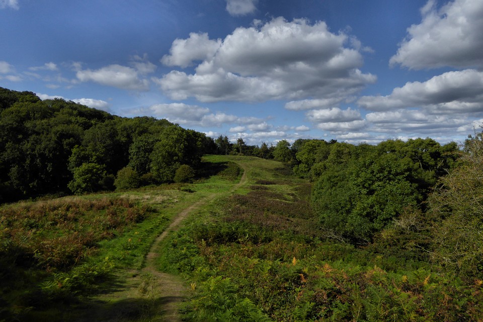
The eastern interior, looking south. The overgrown circles on the left mark the position of round houses.

Wooded section of the northeastern rampart.

Late summer reprise of winter image from 2009. British Camp and the northern section of the Malvern Hills over the right, the Clee Hills in Shropshire visible in the far distance.

The view westwards across southern Herefordshire and into Wales. The Black Mountains escarpment are on the distant skyline.

Looking south along the western ramparts. May Hill in Gloucestershire is centre skyline, with the Forest of Dean to the right of that.

Looking down on the outer western rampart from the inner.

Brash fires and tree felling on the northern ramparts of the eastern section of Midsummer Hill Hillfort (February 2012).
A notice posted on the site explains that the Malvern Hills Conservators are selectively clearing trees to prevent further degradation of the hillfort by protecting it from tree-root damage.
It is not usually considered good practice to burn brash on sites where the underlying archaeology could be damaged.
Please see my Flickr page for more images: https://www.flickr.com/photos/credashill

A notice posted on the eastern section of the hillfort explaining conservation work on Midsummer Hill Hillfort, Herefordshire (February 2012).
The notice explains that the Malvern Hills Conservators are selectively clearing trees to prevent further degradation of the hillfort by protecting it from tree-root damage.
Please see my Flickr page for more images: https://www.flickr.com/photos/credashill

Soil disturbance and brash fires on the summit of the eastern section of Midsummer Hill Hillfort (February 2012).
A notice posted on the site explains that the Malvern Hills Conservators are selectively clearing trees to prevent further degradation of the hillfort by protecting it from tree-root damage.
Please see my Flickr page for more images: https://www.flickr.com/photos/credashill


rampart in foreground


I think the path may be part of shire ditch


Sign

The western rampart.

The open top of the hill.

View north along the Malverns from above the northern entrance to the fort.

View from the Western side of British Camp looking south to Midsummer Hill.

South Western ditch on Midsummer Hill looking over Raggedstone Hill.

Midsummer Camp South gate between Midsummer and Hollybush Hill

The eastern Rampart of Midsummer Camp on the neighbouring Hollybush Hill

Looking down over Midsummer Hill from above Shire Ditch, on the southernmost point of British Camp. November 20th 2005.

Midsummer Hill Hillfort looking South along the narrow point.

Midsummer Hill Northern entrance, looking north out of the hillfort.


Work by Malvern Hills Conservators to preserve Midsummer Hill on the Malvern Hills has been criticised by a local resident.
Sally Gibson, who lives at Coombe Green, close to the hill, says she and her two daughters were “horrified” to see trees being cut down and taken away.
But the Conservators say the work is necessary to preserve Midsummer Hill’s Iron Age fort and enhance the wildlife.
More at : malverngazette.co.uk/news/9552522.Tree_felling_not_what_it_appears/
Visited 2.9.2017
The wheel of the year turns another click. It’s dark when I get up, and mist fills the valley of the Severn as I ride the early train along the estuary, a chill in the air in plain contrast to the heat of the last few days.
By the time I get to the pretty town of Ledbury several hours later, the sun has returned, the heat with it. The summer bus service to British Camp is in its last couple of weeks, and I’m keen to revisit a fort that I last came to on a cold and wet December day some seven and half years ago.
Rather than climbing onto the hills, I take the lower path round British Camp reservoir, unusually starting my walk with a descent rather than getting the uphill out of the way at the start. From down here, the bulk of British Camp looms oppressively, blocking all views westwards. People high on the ramparts are tiny, dwarfed by the enormity of earth and rock.
But I’m not going to get distracted by British Camp today, instead heading south to see the near-neighbours. Woodland canopy provides welcome shade on Tinker’s Hill, continuing more sparsely to Shadybank Common and the picturesque Dales Hall. Across Berrow Downs the view opens up massively to the east, from Bredon Hill (two hillforts) to the Cotswold escarpment (lots of hillforts).
Past Fairoaks Farm a path sneaks invitingly into the trees, so I head off this way. It proves to be a steep pull through Hollybush Roughs, and by the time I emerge onto a wider path I’m feeling rather disorientated about where I am in relation to the fort. A final slog takes me up to the open top of the hill and the memorial shelter mentioned by Carl. This is where I came on my previous visit, but on that occasion I was with a group and we climbed up from the northeast, as cold December rain started to fall. No such problem this time, instead it’s blazing heat to contend with.
There are a few people up here, unsurprisingly on a day like this. I head to the southern edge of the fort, where two ramparts head off around the western circumference. Following the higher of the two, some way below the top of the hill, the lower rampart soon drops away, leaving a wide space and steep hillside between the two levels. The views south and west are terrific, from the inevitable May Hill, across the Forest of Dean, the hills above Cwmbran, Pen-y-Fal (The Sugarloaf), the high ridge of the Black Mountains, the Radnor Forest, the hills of Herefordshire and eventually northwest to the Clee Hills in Shropshire. There must be two dozen hillforts in view from here.
I follow the inner rampart round, a challenge in places as the chest high bracken conceals some ankle catching brambles. Eventually coming to the northern entrance, the higher hills of the Malverns and the obvious contours of British Camp fill the view.
Last time I was here we only visited this higher part of the fort, but actually it comprises less than half of the occupied area. This time I head eastwards downhill, back into the trees. Passing through the woodland, the path re-emerges into another open area. The fort is in the shape of a fat-tailed ‘q’, and the eastern area is broad and flatter than the high part of the hill. Sadly the views here are much more restricted by the trees below the rampart, and the rampart itself is overgrown with brambles that make it impossible to follow. Instead I walk south through the middle of the section – it seems probable that this was the main residential area of the fort, sheltered from the winds and exposure of the western part. On a nice sunny day it feels like a good place to make your home. It’s easy to see why the fort is where it is, well-defended by steep slopes and with commanding views in all directions.
Eventually I re-enter the trees at the southern end, trying to get back to the rampart on the western side of the “tail”. Crossing a fence brings me to the lip of a huge drop, with water glinting far below. This marks the edge of a deep quarry cut into the hillside below the fort, taking the edge of the rampart with it. A potentially dangerous place for the unwary, the sheer drop is head-spinning and I head back to the open area before following the rampart again along its southern route. It’s probable that the main entrance was close to where the body of ‘q’ joins the tail, but a group of teenagers are doing teenager stuff in the trees here, and it’s not clear that an old git lurking in the woods with a camera is going to provoke a positive response, so once again I head back uphill.
By now time has run away, as it always seems to, and it becomes a dash back to British Camp to get to the bus-stop. Still, it’s been a very satisfying return to Midsummer Hill. By the time I get home it’s getting dark, and the fleeting months of summer seem to be ebbing away. The wheel keeps turning.
Visited 6.3.15
As the hill is now owned by the National Trust they have thoughtfully provided a small car park with adjacent information board giving details of local flora and fauna. A metal gate from the car park gives access to the hill and then it is simply a case of following the ‘path’ uphill. Once across the open ground the ‘path’ goes through trees before coming out the other side and the top of the hill. It only takes 15 minutes to walk from the car park to the top of the hill but it is quite steep. By the time I reached the top I was huffing and puffing like a good ‘un – you would have thought I had just climbed Everest! I am definitely not as young or fit as I used to be!
The first thing you notice when you get to the top is a rather ugly concrete seating shelter. This was built in memory of the son of the Reverend who donated the hill to the National Trust who was killed during the first world war. On top of said ugly shelter is another N.T. information board giving details of the hillfort. It mentions the small ‘hollows’ throughout the site which are the bases of the many round houses which occupied the site. I spotted a few but to be honest if it wasn’t for reading about them on the information board I wouldn’t have known they were there.
The weather was very Spring-like with a warm sun and blue sky. However the wing was still cold. To the north you can see the Malvern Hills stretching out in front of you. The Shire Ditch is easily seen snaking its way along the top of the hills. To the east, west and south you can see for miles. Only the far distant horizon was blurred by haze. Although there were several cars in the car park I had the place to myself. All was quiet – not even birdsong for company.
Where the ramparts had been cleared of trees and bushes the single bank from the inside was still approximately 1.5m high in places. Other sections of the defences are still overgrown and it was difficult to tell what condition they are in? I couldn’t stay as long as I would have liked as we had to get back to pick the children up from school and I also wanted to see the ancient yew tree in the churchyard at Much Marcle (well worth seeing – as are the medieval effigies in the church itself)
Provided you are reasonably mobile this is an easy enough hillfort to visit and the views certainly make the effort worthwhile. This was my first bit of ‘old stoning’ of the year and it felt good to be back out in the countryside again. Roll on next month when I have a week in Cornwall to look forward to……
Inside the memorial shelter there is a National trust sign saying: “This iron age Hill fort was given to The National trust in 1923 in memory of Captain Reginald Somers Cocks, M.C.”
From Shire Archaeology’s excellent Hillforts of England and Wales book by James Dyer.
“Rectangular four-poster huts, some measuring 2.4 by 3.6 metres, apeeared at at Credenhill and Midsummer Hill in the fourth century BC. Most of the latter fort’s 12 hectare site was filled with them. S.C. Stanford has used the probable number of huts to estimate the total population of all the Herefordshire hillforts in the mid fourth century BC. This could have been about 25,000, with perhaps 18,000 in the neighbouring Shropshire forts.”
You get great views of British Camp from this hillfort and wonder what the relationship was between these two contour hillforts. When entering the fort, which is approached from the Worcestershire Way, take the small path running East which can be easily overlooked. Carry on walking past the enterance and enjoy the amazing views all around the Malverns. The ramparts are impressive and use the contour of the hill as part of its defence/structure(?).
We walked there whilst at the Big Chill festival which is only a mile or so away. If you know it, walk up the Art Trail and carry on past the Obelisk and then to a gate which leads up to the hillfort.
Aerial view of the site.


