Image Credit: Environment Agency copyright and/or database right 2015.
Image credit: Open Source Environment Agency LIDAR
Image Credit: Environment Agency copyright and/or database right 2015.

Among the Dongas near the Eastern end of the nature reserve is this little mound, seemingly worn into an elongated shape by two of the tracks. It does stand out among the other shapes here, but whether it is a worn-down barrow I can’t say. It’s about 1 meter high and might once have been 15 meters diameter. There’s no obvious sign of a ditch. However, it certainly looks from the dimple on top like some Victorian gent thought the same as me at some point and took a shovel to it.

Looking down one of the deeper dongas toward the Itchen valley and Winchester.
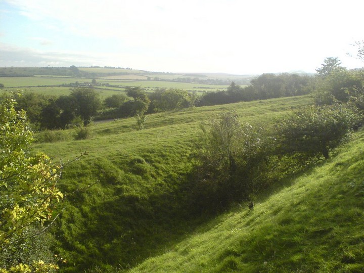
There are several dongas alongside one another at this point, which would have been the only way to descend to the north of St Catherine’s without going down a steep embankment – important if you’re taking animals to market. Going the other way, where the land flattens out on top of the downs they seem to diverge, with some heading east towards Cheesefoot Head and others south-east towards Morestead.

Looking down from two converging dongas at the side of St Catherine’s Hill, this is the view you would have had as you reached the end of your journey over the top of the downs... except for the blue A33 sign in the distance...

From the bottom of the hill, by the river Itchen, showing just how steep it gets and how it would make you think twice about charging up there with your mates for a spot of pillaging. The daisies are growing on the former site of the M3. The current motorway is not so picturesque!

St Catherine’s Hill with River Itchen in foreground. Late 1940’s

The hill in its landscape. Taken from the Cathedral tower. Winchester College in the middle ground.

St Catherine’s Hill Fort – 24.5.2003 – the ramparts on the South side of the hill, looking east.

St Catherine’s Hill Fort – 24.5.2003 – In the ditch of the ramparts on the East side of the hill, looking out of a wooded sections into a sunny clearing.

The Hill and its earthworks still dominate this S. part of Winchester. One wonders why the city never expanded onto this prime bit of real estate as it did up the W. and E. hills.

Sorry Jimit, I know we shouldn’t double up pix, but here’s the same stone surrounded by the ancient people who erected it ... strange tales are told of it’s magical transportation from a mighty quarry in the back of a minivan to the fayre of Glastonphant, where it met with a gifted craftsman. From there to the county of Hampshire, where it was tugged and grappled until it reached the earth in which it now stands.
Behold
THE DONGAS!!!!!
Beautiful people

The stone naming the guilty parties!

From the SW showing the destruction caused by the Twyford Down cutting.

From the W in the grounds os St. Cross Hospital. One of my favourite walks, along the River Itchen, past a waterfall, up Plague Pits Valley (Not as gruesome as it sounds!) and a short stiff walk to the top.
The Uni of Winchester (or King Alfred’s College to locals) have started work on a publically accessible digital archive of the prolonged battle over the re-routing of the M3 motorway. This culminated in a stand-off at the protest camp on the building site in the early 90s, but the digging went ahead and took out earthworks associated with a Neolithic settlement as well as part of the Dongas (see fieldnotes and pics under this site). Rescue excavations took place and found some burials of Iron Age date if my memory serves me correctly. Read all about it at winchester.ac.uk/?page=9559
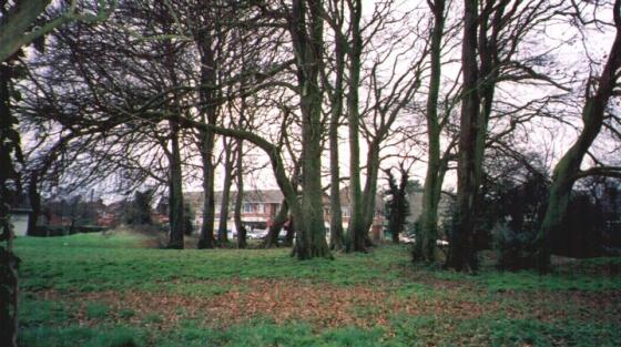
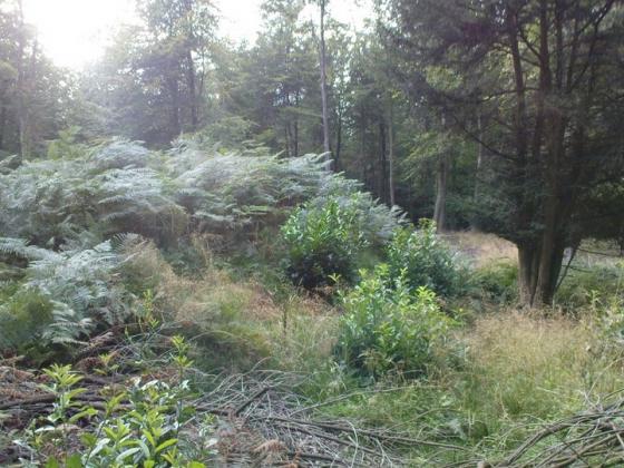
Just to the east of St. Catherine’s Hill (SU 492277 and surroundings) are what remains of the Dongas, the ancient trackways leading down off the South Downs into the valley of the River Itchen and either to ford the river at what became Winchester or to the main entrance to the hillfort on St Catherine’s Hill. I’ve posted a few photos of that area on this site, though they could deserve one of their own. Thankfully a strip of nature reserve is preserving this landscape, though the western end of them was chopped off in the infamous Twyford Down motorway cutting. Easily found (he says – I only recently discovered the main part of them after walking past them oblivious for many years). At the top of Plague Pits Valley, cross the footbridge over the motorway, pausing to make out the faded 1990s Donga Tribe graffiti. The noise pollution here is terrible! You can also come up a path from Garnier Road opposite the St. Catherine’s park & ride car park, which is more direct but less interesting. On the other side of the M3 chasm, go through a gate on your right and then look out for gaps in the bushes to your left, before you reach the top of the slope and another gate. The dongas are waiting for you through there! You get a real sense of the land opening up into a dry plateau, real Thomas Hardy stuff, with a big sky where you can get caught by rain clouds sweeping in off the Channel. Whenever walking about here with my mother, she often commiserates with the ancient folk who did their daily grind up here “without any Long Johns”!
St Catherine’s Hill Fort – 24.5.2003
There were other sites I could have stopped at on the way down to the New Forest but with limited time this proved a decent bet, and probably more interesting for my passenger that an obscure barrow in the middle of a farm field.
The walk up from the car park (by the old railway bridge at 484280) is pretty harsh, but short, and the main path brings you straight into one of the most impressive parts of the ramparts.
A short walk on and you reach the north-east entrance, which leads towards the mizmaze. The east sides gives great views across Winchester. Fortunately the roar from the M3 isn’t that bad because most of it is in a cutting; and anyway, most people visiting the hill fort have probably just used the same M-way to get here so car drivers cannot complain that much. As you walk across the centre of the fort towards the south you slowly drop, which gave me the impression that the ramparts might not be very impressive on the south side, but they are and use the natural steepness of the hill. Walking down the wooden footpath and right, along the stream, brings you back to the car park.
An Iron Age Hill Fort, promenent above the River Itchen (a pre Celtic name) and Winchester. Oval in plan with ditch and bank following the contours. The bank originally topped with a timber pallisade and the entrance on the NE was inturned and protected with watch chambers. Nothing remains of the Chapel of St. Catherine except a small mound and a distinctive clump of trees. A Miz Maze (qv) and to the NE (over M3) the Dongas, the prehistoric and mediaeval trackways worn deeply into the chalk. A modern stone obelisk accuses the people responsible for the vast cutting accommodating the M3! This side of the hill is treated shamefully by the motorway but the W. side has better views and is quiet and peaceful with superb collections of wild flowers and butterflies.
Disabled: From the North car park, several hundred steep steps. From the South West, parking across busy road, long steepish climb on narrow track. From the North East, tiny lay-by gives onto short uphill road and across bridge, steep climb to top. Although this does not give access to the top, this route would give a fine circular trip esp for wheelchair users as the track from the bridge slopes gently down Plague Pits Valley to meet the level path alongside the Itchen Canal which ends at the North car park.
The Belinus ley line is the longest ley line in Britain and was researched by Gary Biltcliffe and his partner Yana. The Belinus line courses through St Catherine’s Hill, nr Winchester, and continues northwards and eventually targets Inverhope in Scotland. On St Catherine’s Hill, two ‘Dragon lines’ or earth energy currents that coil around the ley line can be located here. One dragon line is female [yin] and the other is masculine [yang] these earth energies were known to ancient Chinese geomancers as ‘lung mei’ the Dragon’s breath. The Belinus ley is similar to the St Michael ley line and its two earth energy currents, Mary and Michael, which were discovered by Hamish Miller and Paul Broadhurst in the 1980’s.
According to Paul Devereux and Ian Thomson’s ‘Ley Guide’, Winchester lies on an 11 mile ley from Tidbury Ring to a barrow beyond St.Catherine’s Hill. There was an Iron Age hillfort on this hill and in the 12th Century a small chapel dedicated to St.Catherine was built, of which slight traces remain. The Castle Hall in nearby Winchester has lots of Arthurian legends attached to it, which I’m afraid to say do bore me.
Aerial view from FlashEarth....
flashearth.com/?lat=51.046591&lon=-1.309853&z=16.2&r=0&src=1