Skip to content
Julian Cope
presents
The Modern
Antiquarian
Latest
Posts
Sites
Map
Blog
Forum
search
Search
⚠️
Sign in
more_horiz
United Kingdom
England
Northern England
Cleveland
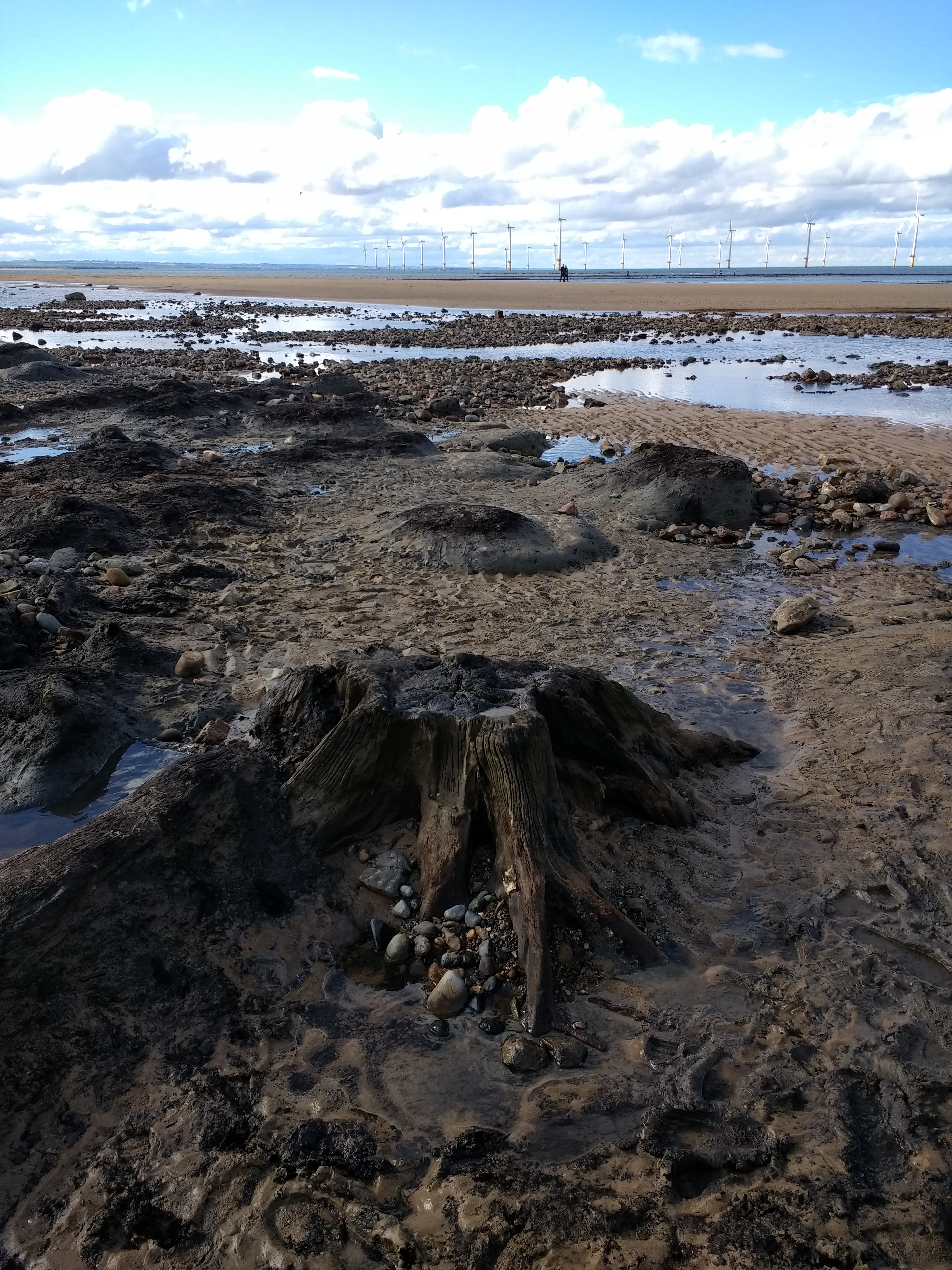
Redcar Beach Submerged Forest
Mesolithic site
NZ599257
expand_more
Nearest town:
Redcar (2km ESE)
OS reference:
NZ599257
OS sheet:
93
Latitude:
54° 37' 21.77 N
Longitude:
1° 4' 19.86 W
Added to TMA by
spencer
Images (9)
Add
content
Images
spencer
Feb 20, 2019
spencer
Apr 24, 2018
spencer
Apr 24, 2018
spencer
Apr 24, 2018
spencer
Apr 24, 2018
spencer
Apr 24, 2018
Seven thousand year old birch bark...
Image credit: Mike Purslow
spencer
Apr 24, 2018
spencer
Mar 25, 2018
Image credit: Mike Purslow
spencer
Mar 25, 2018
Sites within 20km of
Redcar Beach Submerged Forest
Upleatham
Round Barrow(s)
•
5.96km SE
photo
6
description
1
Patterson’s Bank
Round Barrow(s)
•
6.04km SE
photo
15
forum
1
description
3
link
3
Sandy Lane
Ancient Trackway
•
6.13km SE
photo
1
Soapwell Wood
Round Barrow(s)
•
6.38km SE
Sandy Lane Standing Stone
Standing Stone / Menhir
•
6.61km SE
photo
2
description
2
Upleatham
Mesolithic site
•
6.64km ESE
photo
1
Court Green Howe
Round Barrow(s)
•
7.58km SSW
Cat Nab
8.14km E
photo
3
description
2
Eston Nab
Hillfort
•
8.45km SSW
photo
13
description
15
link
3
Eston Moor Carved Stone
Cup and Ring Marks / Rock Art
•
9.16km SSW
photo
6
description
1
link
1
Airy Hill Farm
Round Barrow(s)
•
10.05km SE
description
4
Mount Pleasant
Round Barrow(s)
•
10.06km SSW
photo
2
description
1
Warsett Hill
Barrow / Cairn Cemetery
•
10.19km E
photo
7
Hartlepool Mesolithic/
Neolithic Forest
Mesolithic site
•
10.23km WNW
photo
3
description
1
link
2
Howe Hill
Round Barrow(s)
•
11.31km ESE
Brotton Howe
Cairn(s)
•
11.85km ESE
forum
1
description
1
Highcliff Nab
Ancient Village / Settlement / Misc. Earthwork
•
11.94km SSE
photo
5
description
1
link
1
Hanging Stone
Natural Rock Feature
•
12.21km S
photo
3
description
1
Three Howes (Guisborough Moor)
Barrow / Cairn Cemetery
•
12.76km SSE
photo
1
Newton Under Roseberry Stone
Standing Stone / Menhir
•
12.92km SSW
photo
2
description
1
Cod Hill, Sleddale
Round Barrow(s)
•
13.17km SSE
description
1
Roseberry Topping
Sacred Hill
•
13.23km S
photo
16
forum
3
description
21
link
4
Lockwood Beck Farm
Standing Stone / Menhir
•
13.55km ESE
photo
2
Gisborough Moor
Round Barrow(s)
•
13.81km SE
photo
1
Hob on the Hill
Barrow / Cairn Cemetery
•
14km SE
photo
5
description
2
Percy Rigg
Ancient Village / Settlement / Misc. Earthwork
•
14.23km SSE
photo
1
description
4
Great Ayton Moor Enclosure
Enclosure
•
14.29km S
photo
4
description
5
Great Ayton Moor Chambered Cairn
Cairn(s)
•
14.3km S
photo
8
description
3
link
1
The Bridestones
Ancient Village / Settlement / Misc. Earthwork
•
14.34km SE
photo
5
description
2
link
1
Percy Rigg Standing Stone
Standing Stones
•
14.49km SSE
photo
2
description
1
Black Howes
Barrow / Cairn Cemetery
•
14.74km SE
photo
2
description
3
Street House
14.95km E
photo
3
description
2
link
2
Commondale Moor
Cairn(s)
•
15.01km SE
photo
2
Commondale
Stone Circle
•
15.36km SSE
photo
14
forum
1
description
6
link
2
Old Castle Hill
Stone Row / Alignment
•
15.37km SE
photo
6
description
3
link
1
Freebrough Hill
Sacred Hill
•
15.8km ESE
photo
10
forum
2
description
7
Stony Ruck
Round Barrow(s)
•
16.06km ESE
Moorsholm Spring
Barrow / Cairn Cemetery
•
16.06km ESE
Kildale Un-named stone
Standing Stone / Menhir
•
16.19km SE
photo
2
description
2
Moorsholm Rigg
Enclosure
•
16.32km ESE
Sand Hill
Cairn(s)
•
16.44km SE
photo
1
description
1
Howe Hill, Newby
Round Barrow(s)
•
16.92km SW
photo
3
description
4
Kildale
Cup and Ring Marks / Rock Art
•
17.23km SSE
description
1
Haw Rigg Barrows
Barrow / Cairn Cemetery
•
17.38km ESE
description
1
Three Howes Rigg (Commondale)
Round Barrow(s)
•
17.38km SE
photo
5
description
1
Herd Howe
Round Barrow(s)
•
17.44km ESE
photo
6
link
1
Gerrick Moor
Standing Stone / Menhir
•
17.45km ESE
photo
2
description
2
link
2
Kildale Moor
Cairn(s)
•
17.69km SSE
photo
1
description
1
Gerrick Moor 1
Round Barrow(s)
•
17.7km ESE
photo
3
Gerrick Moor Dyke
Dyke
•
17.73km ESE
description
1
Roxby
Cup and Ring Marks / Rock Art
•
17.95km E
photo
9
link
1
Box Hall/
Castleton Moor
Enclosure
•
17.95km SE
photo
1
description
1
Robin Hood’s Butts (Gerrick)
Round Barrow(s)
•
18.24km ESE
photo
3
description
1
Baysdale
Cup Marked Stone
•
18.42km SSE
photo
5
description
1
Elm Lodge, Danby Low Moor
Long Barrow
•
18.77km ESE
photo
2
description
1
Battersby Moor Cross-Ridge Boundary
Dyke
•
19.1km SSE
photo
6
description
1
Staithes
19.44km E
description
2
Crown End, Westerdale
Ancient Village / Settlement / Misc. Earthwork
•
19.53km SE
photo
1
link
1
Westerdale Moor
Stone Row / Alignment
•
19.55km SE
photo
6
description
1
link
1
Little Hograh Moor
Standing Stones
•
19.65km SE
photo
2
description
1
search
I’m looking for…
location_on
photo
ondemand_video
forum
description
link