The Modern Antiquarian
Log in
|
Register
Home
Latest Posts
Forums
Maps
Help
Browse Sites
News
Blog
Contributors
The Books
Select
-
Belgium
Denmark
Eire
France
Germany
Greece
Italy
The Netherlands
Norway
Portugal
Republic of Malta
Spain
Sweden
Switzerland
United Kingdom
England
Southern England
Wiltshire
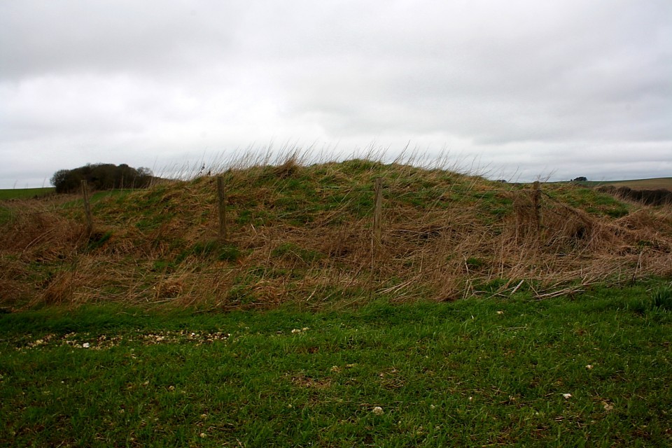
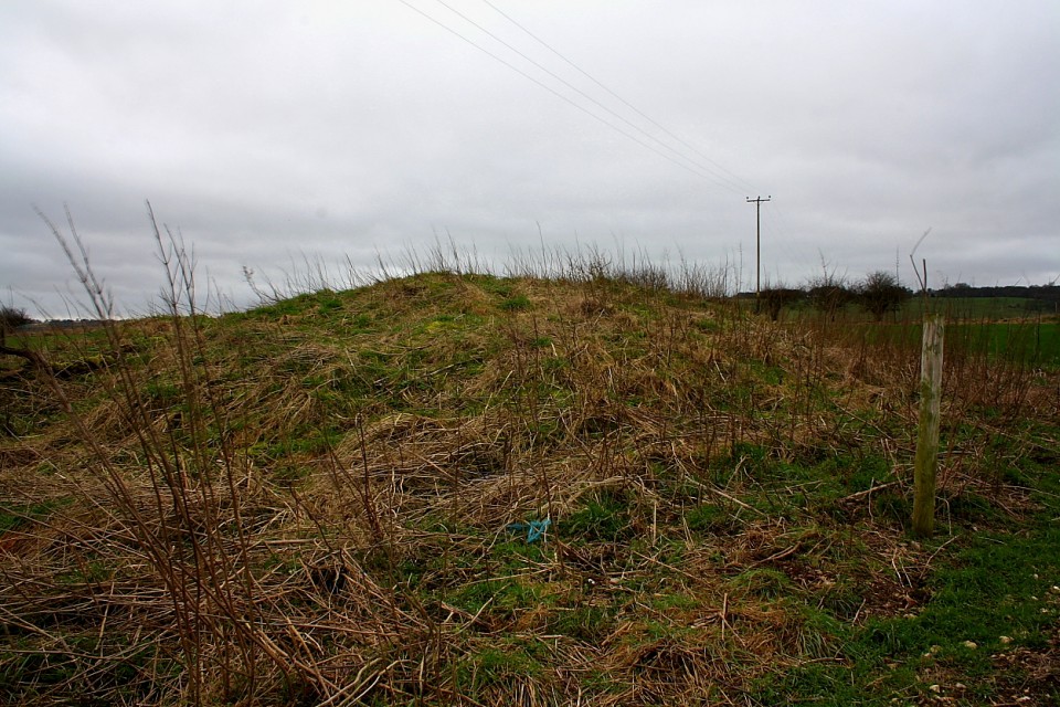
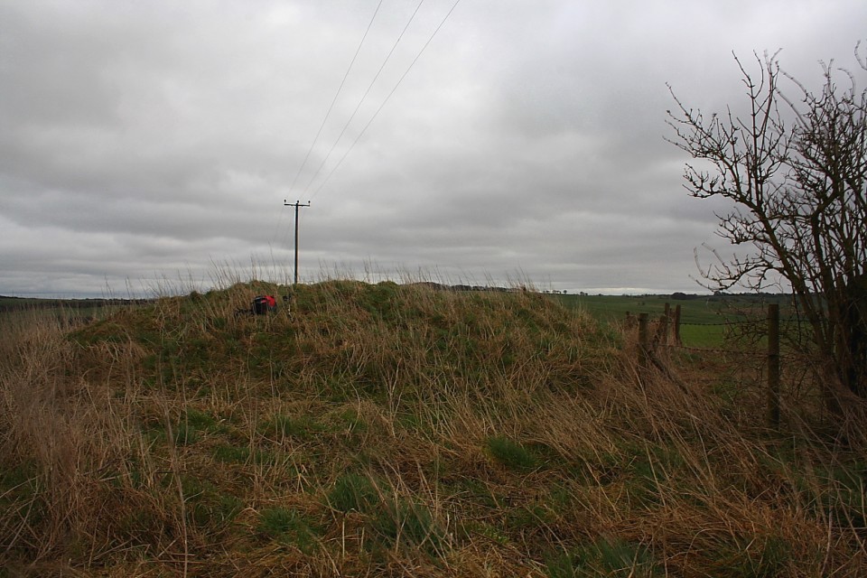
Sugar Hill
Aldbourne 7
Round Barrow(s)
Aldbourne 7 (Round Barrow(s)) on The Modern Antiquarian, the UK & Ireland's most popular megalithic community website. 3 images, plus information on many more ancient sites nearby and across the UK & Ireland.
Image © Robert Gladstone
Nearest Town:
Marlborough (11km SSW)
OS Ref (GB):
SU24457821 /
Sheet: 174
Latitude:
51° 30' 6.44" N
Longitude:
1° 38' 51.76" W
Added by
GLADMAN
Images (3)
Miscellaneous (1)
0 discussions
Start a topic
Show |
Hide
Web searches for Aldbourne 7
Flickr
Google
Google Images
MAGIC
The Megalithic Portal
Bing
Stone Pages
Streetmap.co.uk
Wikipedia
Show map
(inline Google Map)
- Sites within 20 km -
-
Sugar Hill (0.36km WNW) (10 posts)
Warren Farm (1km WSW) (2 posts)
Aldbourne Four Barrows (1.02km SE) (18 posts)
Aldbourne 'Cup Barrow' (1.17km SSE) (2 posts)
Aldbourne (west of Giant's Grave) (1.79km S) (8 posts)
The Giant's Grave (Aldbourne) (1.81km SSE) (21 posts)
Shipley Bottom (2.37km W) (4 posts)
Liddington Warren Farm (2.53km WNW) (16 posts)
The Aldbourne Way (3.02km ESE) (1 post)
Aldbourne Blowing Stone (3.32km ESE) (6 posts)
Liddington Castle (3.97km W) (38 posts)
Three Barrows (4.2km NE) (11 posts)
Ashbury Earthwork (4.48km NE) (1 post)
Alfred's Castle (5.13km NE) (15 posts)
Fognam Clump Barrow (5.18km ENE) (1 post)
Fognam Clump Barrow (5.18km ENE) (0 posts)
Ashdown Park Sarsens (5.59km NE) (13 posts)
Ballards Copse Long Barrow (6.26km ESE) (4 posts)
Whitefield Farm (6.27km WSW) (1 post)
Membury Camp (6.29km E) (32 posts)
Tower Hill (7km NE) (1 post)
Coate Stone Circle (7.42km WNW) (33 posts)
Ashbury (7.49km N) (4 posts)
Coate Mound (7.75km W) (2 posts)
Wayland's Smithy (8.05km NNE) (202 posts)
Hangman's Stone (8.09km ENE) (5 posts)
Ogbourne St Andrew Church (8.16km SW) (9 posts)
Ogbourne St Andrew Barrow (8.16km SW) (23 posts)
Devil's Footprint (8.49km W) (1 post)
Coin Barrow (8.72km NNE) (1 post)
Idlebush Barrow (8.73km NE) (6 posts)
Snivelling Corner (8.76km N) (2 posts)
Broome Temple (8.8km W) (2 posts)
Broome Long Stone (8.8km W) (1 post)
Adstone (8.82km NNE) (1 post)
Burderop Wood Stone Circle (8.89km W) (1 post)
Lambourn Long Barrow (9.33km ENE) (23 posts)
Hardwell Camp (9.48km NNE) (24 posts)
Lambourn Sevenbarrows (9.5km ENE) (48 posts)
Barbury Castle (9.51km WSW) (59 posts)
Ogbourne Maizey Down Barrows (9.65km WSW) (2 posts)
Uffington Castle (9.74km NE) (63 posts)
Sparsholt Down (9.83km NE) (1 post)
Uffington Castle Long Mound (9.96km NE) (5 posts)
Uffington Castle Round Barrow (10.07km NE) (8 posts)
Uffington White Horse (10.15km NE) (144 posts)
Forest Hill Farm (10.19km SSW) (5 posts)
Marlborough Common Golf Course Barrows (10.19km SW) (3 posts)
Dragon Hill (10.35km NE) (42 posts)
Rams Hill (10.71km NE) (11 posts)
Moss Hill (10.96km ENE) (1 post)
Temple Bottom (11.13km WSW) (4 posts)
Savernake Temple (11.17km S) (1 post)
Sparsholt Down (edge of) (11.21km ENE) (3 posts)
Marlborough Mound (11.31km SW) (28 posts)
Barton Copse Barrows (11.39km SW) (1 post)
Blowing Stone (11.83km NE) (36 posts)
Savernake Lodge (11.89km S) (6 posts)
Manton Down (11.92km SW) (16 posts)
Rough Hill Row (11.94km WSW) (1 post)
East Garston Ditch (12.01km ENE) (14 posts)
Pigtrough Bottom (top of) (12.05km NE) (7 posts)
Rough Hill Barrows (12.05km WSW) (1 post)
Manton Round Barrow (12.07km SW) (12 posts)
Granham Hill (12.1km SW) (2 posts)
Rushy Platt Bowl Barrow (12.1km W) (4 posts)
Long Tom (Fyfield) (12.17km SW) (11 posts)
Hackpen Hill (Wiltshire) (12.2km WSW) (10 posts)
Broad Stones (Clatford) (12.28km SW) (2 posts)
Fyfield Down settlement (12.4km WSW) (4 posts)
Devil's Den (12.62km SW) (126 posts)
Fyfield 1 and 2 barrows (12.65km SW) (3 posts)
Savernake (12.65km S) (11 posts)
Old Chapel (12.68km WSW) (2 posts)
Chisbury (12.73km SE) (10 posts)
Hackpen Hill (Oxfordshire) (12.76km ENE) (11 posts)
Clatford Barrows (12.87km SW) (1 post)
Fiddlers Hill (13.03km WSW) (2 posts)
Kingston Lisle Tumulus (13.07km NE) (4 posts)
Devil's Punchbowl (13.07km ENE) (7 posts)
Fyfield Down (13.13km WSW) (22 posts)
Berwick Bassett Down (13.17km WSW) (4 posts)
Monster Stone (13.23km SW) (7 posts)
The Mother's Jam (13.38km SW) (22 posts)
Overton Down (13.63km WSW) (20 posts)
Stanton Fitzwarren (13.63km NW) (4 posts)
Bincknoll Castle (13.75km W) (13 posts)
Experimental Earthwork (13.8km WSW) (10 posts)
Monkton Down (13.93km WSW) (13 posts)
Pickledean Stone Circle (14km SW) (12 posts)
Piggle Dene (14.09km SW) (20 posts)
Down Barn standing stones (14.39km SW) (5 posts)
Mud Lane Barrow (14.43km S) (1 post)
Winterbourne Monkton oval mound (14.46km WSW) (1 post)
Square Copse Barrows (14.72km S) (1 post)
White Barrow (Lockeridge) (14.73km SW) (1 post)
Penning (14.77km WSW) (14 posts)
Lockeridge Dene (14.87km SW) (25 posts)
Avebury Down (15.03km WSW) (27 posts)
Highworth Circles (15.15km NNW) (1 post)
Winterbourne Bassett (15.23km WSW) (49 posts)
Little Coxwell Camp (15.24km NNE) (15 posts)
Segsbury Camp (15.31km ENE) (30 posts)
Barrow Copse (15.44km SW) (30 posts)
Woolley Downs Barrows (15.45km ENE) (4 posts)
The Shelving Stones (15.53km WSW) (1 post)
Castle Hill (Broad Blunsdon) (15.63km WNW) (10 posts)
Crofton (15.71km SSE) (2 posts)
Martinsell (15.81km SSW) (22 posts)
Winterbourne Monkton (Churchyard) (15.91km WSW) (8 posts)
Millbarrow (16.13km WSW) (2 posts)
West Kennet Hollow Way (16.14km SW) (1 post)
Falkners Circle mounds and barrows (16.16km WSW) (3 posts)
Falkners Circle Long Barrow (16.17km WSW) (1 post)
Falkner's Circle (16.18km WSW) (41 posts)
Overton Hill (16.28km SW) (113 posts)
West Kennet Avenue Settlement Site (16.37km WSW) (29 posts)
Avenue stone with axe grinding marks (16.41km WSW) (13 posts)
The Cove (16.41km WSW) (65 posts)
The Sanctuary (16.45km SW) (80 posts)
Avebury (16.49km WSW) (487 posts)
West Kennett Avenue (16.49km WSW) (148 posts)
Badbury Hill Camp (16.57km N) (9 posts)
Waden Hill (16.67km WSW) (6 posts)
Huish Hill (16.86km SSW) (9 posts)
West Kennett Palisaded Enclosures (16.87km SW) (5 posts)
Giant's Grave (Martinsell) (16.92km SSW) (19 posts)
Silbaby (16.99km SW) (26 posts)
Windmill Hill (17.11km WSW) (98 posts)
East Kennett (17.15km SW) (60 posts)
Silbury Hill (17.39km WSW) (227 posts)
Pewitt Farm Barrow (17.42km ENE) (9 posts)
West Kennett (17.44km SW) (225 posts)
Swallowhead Springs (17.57km SW) (45 posts)
Horslip (17.58km WSW) (6 posts)
Harestone Down Stone Circle (17.58km SW) (25 posts)
Beckhampton Road Enclosures (17.67km WSW) (2 posts)
Beckhampton Avenue (17.7km WSW) (13 posts)
Draycott Hill (17.75km SW) (28 posts)
Little Avebury (17.76km SW) (20 posts)
Wagon and Horses Barrow Cemetery (17.78km WSW) (1 post)
South Street (17.84km WSW) (11 posts)
The Longstone Cove (17.87km WSW) (78 posts)
Harestone Down barrow (18.01km SW) (3 posts)
Long Stones (18.06km WSW) (16 posts)
Beckhampton Plantation Stone Circle (18.25km SW) (3 posts)
Penning Barn (18.27km WSW) (3 posts)
Golden Ball Hill (18.28km SW) (13 posts)
Beckhampton Penning Enclosure (18.34km SW) (1 post)
Yew Down Barrow (18.49km ENE) (1 post)
Beckhampton Penning Barrow Cemetery (18.66km SW) (1 post)
Little London Pair (18.83km WSW) (8 posts)
Little London Barrow (18.86km WSW) (1 post)
Lord Wantage Monument Barrow (18.93km ENE) (4 posts)
Botley Copse (18.95km SE) (1 post)
Ringsbury (18.99km W) (11 posts)
Goddards Barn Barrow (19km ENE) (6 posts)
Harepit Way (19.01km WSW) (1 post)
Yatesbury Village Barrow (19.05km WSW) (1 post)
Knap Hill (19.1km SW) (47 posts)
Knap Cottage Stone (19.12km SW) (3 posts)
Yatesbury Field Cursus (19.19km WSW) (1 post)
Easton Clump (19.22km S) (3 posts)
Inkpen Hill (19.26km ESE) (2 posts)
Yatesbury Field Barrow (19.3km WSW) (1 post)
Fox Covert Barrow Group (19.34km WSW) (4 posts)
Knap Hill and Walker's Hill (19.35km SW) (8 posts)
Knoll Down Barrows (19.36km WSW) (2 posts)
Pewsey Church (19.52km SSW) (8 posts)
Noland's Farm Barrow (19.59km WSW) (1 post)
Knap Hill Pass (19.6km SW) (2 posts)
Old Bath Road Barrow (19.62km WSW) (11 posts)
Pewsey (19.68km SSW) (9 posts)
Midsummer Wood Barrow (19.69km ENE) (1 post)
Adam's Grave (19.81km SW) (69 posts)
Round Hill Mound (19.82km ENE) (3 posts)
White Horse Barrow (19.82km SW) (11 posts)
Combe Gibbet (19.93km ESE) (13 posts)
West Down Roman Road Barrows (19.96km WSW) (9 posts)
Allington Down (19.99km SW) (15 posts)
- Facilities within 20 km -
-
Foxlynch (Camping Site: 6.9 km SW)
Raj Indian Restaurant (Restaurant: 10.6 km SSW)
Marlborough Tourist In... (Tourist Information: 10.9 km SSW)
The White Horse Inn (Bed & Breakfast: 10.9 km NNE)
Blowing Stone Inn (Pub: 12.6 km NNE)
Fox and Hounds Inn (Pub: 12.7 km NNE)
The Hatchet (Pub: 14.8 km NE)
The New Inn (Bed & Breakfast: 15.7 km SW)
The New Inn (Bed & Breakfast: 15.7 km SW)
Avenue Farm (Camping Site: 15.7 km SW)
Manor Farm (Bed & Breakfast: 16.1 km NE)
The Red Lion Inn (Pub: 16.6 km SW)
The Lodge Avebury (Bed & Breakfast: 16.6 km SW)
Alexander Keiller Museum (Museum: 16.6 km SW)
Manor Farm (Bed & Breakfast: 16.6 km SW)
Avebury Tourist Inform... (Tourist Information: 16.6 km SW)
The Old Forge (Bed & Breakfast: 16.7 km SW)
- Add -
-
Add news
Add an image
Add fieldnotes
Add folklore
Add miscellaneous
Add a link
-
Add a site
Add a nearby facility
Add an alternative name/spelling
Images
(click to view fullsize)
Add an image
Miscellaneous
Add miscellaneous
Pastscape has this:
"A Bronze Age bowl barrow.... was excavated by Greenwell in the 1880's who found a cremation and a flint flake. The mound is visible standing to a height of 1.8m and the ditch of 20m in diameter is of 0.3m in depth."
Comments (0)
|
Add a comment
|
Permalink
Posted by
GLADMAN
21st January 2018ce

 Posted by GLADMAN