Image credit: Robert Gladstone

Looking from the (very) well defended main entrance of Tre’r Ceiri. The cairn can be clearly seen to the left of the summit ridge.


Speaking of superlative, Tre’r Ceiri is seen below to the right. Northern Snowdonia lies beyond...

Looking into the sun (approx south-westerly) across the shattered remnants of the ‘other cairn’.


The monument really is a superlative example of an upland cairn.

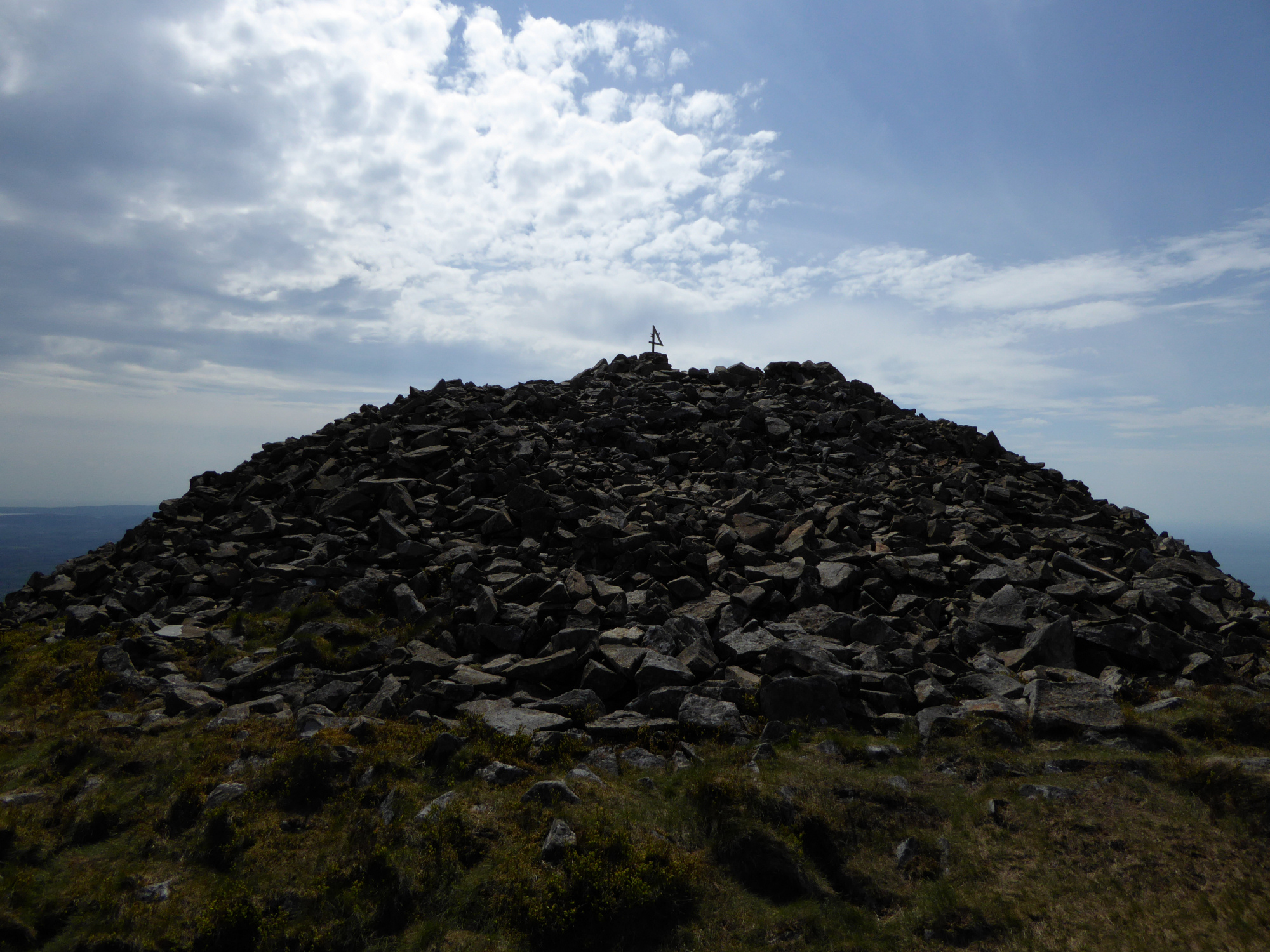
The summit...….

Zooming down from on Yr Eifl.

The view west from Yr Eifl, really not bad at all.

The smaller less fortunate cairn, and Carn’s Boduan and Fadrun.

Looking over the smaller less fortunate cairn to the big one.

Looking towards Gyrn Ddu and central Snowdonia.

A big cairn called number four.

Looking west along the north coast of the Lleyn.

Looking over the walkers shelter in the big cairn to Garn Boduan and the further Carn fadrun

From Tre’r Ceiri

Yr Eifl (centre) with Tre’r Ceiri on its lefthand peak and Carn Fadrun over to the distant right. From Traeth Llanddwyn, Ynys Mon.

Yr Eifl from Dinas Dinlle, at the end of a walk that began under its crags.

The northwestern peak, Garn For, drops straight down to the sea. The cairn is on top of the summit, balanced precariously above the ongoing quarrying.

Yr Eifl’s main summit (left) and Garn For (right), both topped with cairns. From Merbwll to the northeast.

The odd thing mounted on the trig pillar is a metal number “4”, with an “A” and “H” affixed to its sides. I have no idea what it is meant to signify.

Looking northeast from the summit cairn. Yr Wyddfa crowns the centre skyline, with the Carneddau and Glyders to the left, the Nantlle ridge in front to the right, Moel Hebog to the right again and the Moelwyns far right. The ramparts of Tre’r Ceiri are visible on the edge of the shot, right middle.
On a clear day the Wicklow Mountains, Isle of Man and Pembrokeshire can be seen from Yr Eifl.

The top of the summit cairn has been messed about to make an inevitable shelter, but the cairn is so large it seems less intrusive than might normally be the case.

Looking southwest from the summit cairn. G/F sits by the southwestern cairn and admires the magnificent views.

The massive summit cairn from the southwestern cairn. Beaches of Ynys Mon to the left, mountains of Snowdonia to the right.

The low southwestern cairn, now surmounted with two modern stone piles and difficult to distinguish from the rocky surface of the summit ridge. Looking south towards Pwllheli and Llanbedrog.

Looking down on Garn For (Pen Bwlch Yr Eifl), the northwestern of the three summits of Yr Eifl, from the cairns on the central summit. The cairn on Garn For is placed precariously above the ongoing quarrying of the peak’s north face. Hazy today, but Holyhead Mountain at the tip of Ynys Mon can be seen on the horizon above Garn For.

Looking southwest across the low southwestern cairn. Many prehistoric sites are visible on the peninsula below, most notably the superb hillforts of Carn Fadrun, Garn Boduan and the long promontory of Trwyn Porth Dinllaen.

From the south the rocky nature of the hill really becomes apparent, tumbled scree and boulders overlain by scanty heather and bracken making for a daunting climb.

Garn For and Garn Ganol, the northwestern and central peaks of Yr Eifl. Both have cairns on the summits. The track is the old road that leads over Bwlch yr Eifl between the two peaks, and is likely to be a prehistoric trackway as well as being used by the Romans as a link to the fort at Segontium (Caernarfon).

Yr Eifl from Pistyll to the southwest. The damaged northern summit (Garn For or Pen Bwlch yr Eifl) is centre of image, the highest summit Garn Ganol to the right. The top of Tre’r Ceiri can just be seen to the right of that.

Yr Eifl, Tre’r Ceiri and Mynydd Carnguwch at dusk, from Pwllheli to the south.
Yr Eifl means “the Trident”, from its three striking peaks. The Welsh name has been Anglicised into The Rivals.
One the three peaks is occupied by the frankly astonishing Tre’r Ceiri hillfort, but is also topped with a large Bronze Age burial cairn. The other two summits also have BA cairns.
The highest of the three peaks, Garn Ganol, rising to 564m OD straight from sea-level at Nant Gwrtheryn, boasts two cairns, one substantial and intact, the other rather wrecked and fragmentary. GAT:
Summit cairn at SH36484474
A large featureless summit cairn on top of Yr Eifl. Visible on skyline from parts of Pen Llyn to W and SW and from Tre’r Ceiri to SE. Made from randomly piled large stones collected from around summit. A substantial hole, forming a shelter, has been dug into the cairn, about 2.5m wide and up to 0.8m deep. This contains broken glass, burnt plastic etc. Trig pillar also stands on cairn, also 1 small (1.5m diameter, 0.3m deep) excavation in W side.
Southwestern cairn at SH36464472
33.3m SW of the summit cairn. The top levelled and used as a platform for a small modern cairn.
Low circular cairn markedly different from the other cairn on Yr Eifl (PRN 616). Made up of small stones 5cm long with occasional larger 0.5m long slabs. Very low and flat in profile intervisible with Tre’r Ceiri cairn & Carnguwch. Could this cairn have been robbed to form 616?
The northwestern peak (Garn For or Pen Bwlch yr Eifl) has been (and still is being) badly damaged by quarrying, but there is still a cairn on its summit. GAT:
A surprisingly large cairn considering that the summit area is quite small. There is an original cairn base about 10m diameter and up to 1.2m high and this has traces of laid slab kerbing in places – not just a heap. On this has been built a modern ‘pillar’ cairn about another 2m high and there has been other disturbance as well. The original cairn is so large and well-built it seems likely to be prehistoric and resembles those on Yr Eifl and Tre’r Ceiri.