Details of barrows on Pastscape
Four bowl barrows not published by OS:- Exmoor No.20, SS 79193550, is 19 paces diameter and 2 ft high, and has a hollow in the centre. Exmoor Nos. 21a and b, adjoining mounds at SS 79243549. 21a, the NE mound, is 7 paces diameter by 1.5ft. high and is ditched. 21b, the SW mound, is 7 paces diameter by 2.5 ft.high and is also ditched. Exmoor No 22, SS 79413548, is mutilated and was first discovered from A.Ps. It is 11 paces in diameter and 2ft high. (1)
Grinsell’s No. 20, at SS 79213554 is a truncated bowl barrow 0.6m high. 22, at SS 79433548, has been almost completely destroyed. A small oval mound 0.6 m high is all that remains though the original extent of the barrow can be traced as a crop mark. Surveyed at 1/2500.
21a and b, at SS 79253552 are both small square mounds enclosed by a slight ditch. They do not seem to be of any great age and may be drying platforms associated with peat digging (2)
Exmoor 20 and 22. Bowl barrows listed, details as Authy 1. Visited by Grinsell 27th Sept 1961 and 23rd April 1962. Known as Sherdon Barrows(together with SS 73 NE 4), and so called in Chase records of 1794 and1819(a).Exmoor 21a and 21b. Listed as ‘doubtful or rejected’. (3)
(SS 79213554) Tumulus (NR)(SS 79433548) Tumulus (NR) (4)
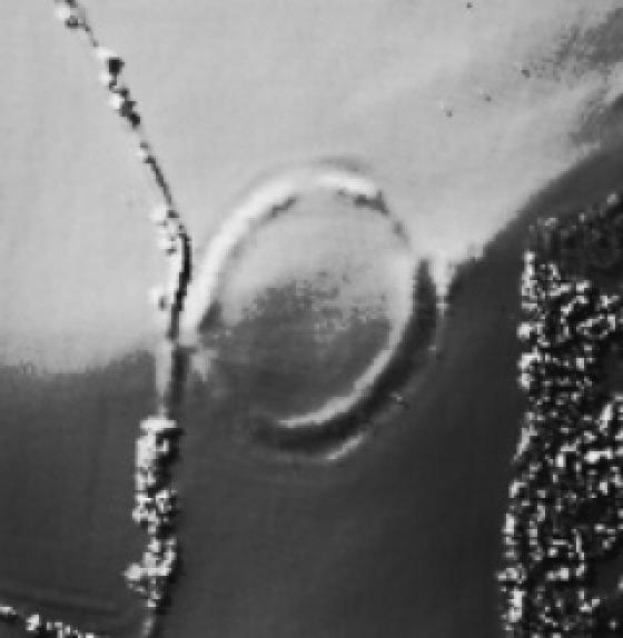
Grinsell No 20, centred at SS 7921 3554 on open moorland, consists of a truncated, turf & reed-covered stony mound 16.5m in diameter (summit diameter of 13m) and 0.4m high.A narrow slot has been driven through the south edge and opens out into a rectangular pit, measuring 3.5m by 6.5m and 0.4m deep, to the south of the centre of the mound. This, and the truncated form of the mound are the result of stone robbing activity.
Grinsell No 22, centred at SS 7943 3548 in improved pasture, consists of a turf-covered oval mound measuring 7.3m north-south by 9.5m and 0.3m high. Around the mound is a swathe of disturbed ground which probably corresponds with the “cropmark” mentioned by source 2. This presumably represents the former extent of the barrow, and would have given a diameter of 13.2m.
The possible peat drying platforms, mentioned by source 2, are centred at SS 7925 3552. They consist of a pair of adjacent turf covered mounds enclosed within a shallow ditch. The eastern, flat-topped mound is rectangular, measuring 6.2m by 7.3m and 0.4m high. The western mound is sub-circular and measured 6.3m in diameter and is 0.5m high. The two mounds are separated by a shallow ditch. Both lie within a rectangular area measuring 15.5m by 8.5m and defined by a sharp-sided ditch 1m wide and 0.3m deep. The purpose of the mounds is unclear. The sharpness of the enclosing ditch suggests a Post-Medieval date.
Source 2’s classification as peat drying mounds is unfounded. Local information (source 7) states that peat was never dried on mounds or platforms within memory. Source 8 suggests that on Bodmin Moor where similar features have been identified and so classified, the mounds represent peat charcoal production sites. However, there is no known documentary evidence for peat charcoal production on Exmoor. (6-8)
The mounds described above are clearly visible on aerial photographs, although only one small sub-rectangular square (identified as a peat stand) can be seen. It is clearly very different in size and form to the larger barrows at SS 7921 3554 and SS 7943 3548. The mounds lie in an area of extensive peat cutting, and it is possible that the sub-rectangular mound is related to this activity (9).