Upwards at forty five degrees.
Image credit: Howburn Digger
Upwards at forty five degrees.

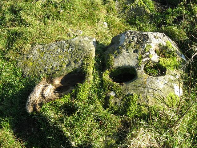
What appears to be a curving line of very deep cups, a row of very small and some pecking.

The three slabs on the hillside a few hundred yards from the Crookedstone.


One of the deep natural cups.


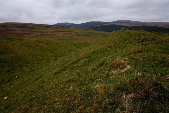
It really does point upwards at forty five degrees. The profile of the top of the stone appears to mirror the fold in the hills to the North East on the other side of the M74.


The big natural cups can be seen quite a distance away.
Splendid Isolation – Crookedstone – A Stone Alone
31 October 2010
My domestic duties done and household chores completed I nipped out for a couple of hours to seek out the Crookedstone. I turned out of the road-end and headed south on the A702 into an afternoon of perfect autumn stillness, brilliant sunshine, blue skies and rusty coloured hills.
I turned onto the B7076 after Abington and stayed on it, by-passing Crawford and ignoring the signs willing me to visit Elvanfoot and Drumlanrig Castle. After another mile, the B7076 curved over the M74 and a wee signpost bearing the legend “Crookedstone” pointed to a turnoff. I drove down and came to a wee level crossing. You have to cross the main Scotland/ England West Coast Rail Link to get to this site. The crossing gates are hand-operated and to raise them you have to pump them up by a handpump. I quickly changed my mind when out of nowhere a Virgin Pendolino hurtled past me, causing instant sphincter tightening fear and sucking the breath out of my lungs. I decided to leave my car where it was and cross the tracks by the wee pedestrian gates. I crossed rather quickly and was immediately spotted by a gang of sheep who showed a vague interest in me before rushing off along the peaty banks of the Clyde Burn like an absurd impulse towards Elvanfoot.
I tramped the half mile or so up the farm road. The stone is in a field next to the farmhouse and as I approached I was greeted by three large snarling, barking hounds. Thankfully they were behind a high fence. The racket brought out the farm’s occupants. They looked rather surprised to find a visitor wishing to see the stone but were not in the least bit “off-ish”. The farmer was kind enough to point me a way to access the field with the Crookedstone in it, and asked me to close the access gate firmly as there were tupps in the Crookedstone’s field who were aching to attend on the ewes in the adjoining field.
The stone is about two metres long and stands about one and a half metres high, pointing upwards at 45 degrees. It is covered with large natural looking cup marks and leans Northwards in its gently sloping field about a mile across the flat valley floor of the River Clyde from Air Cleuch. The top of the stone’s profile appears to mirror that of a fold in the hills to the North-East. I wondered about rising sun alignments. I wondered about the robbed-out cairns I’d seen at the side of the field. I wondered about the strange isolation of the site. Cut off on the West and South sides by the River Clyde, Daer Water and Potrail Water, cut off by heights of Beattock Summit to the East and completely cut-off from the North by the M74, the B7076, the West Coast Main Railway Line and the Clyde Burn.
A mile or so to the South there is a MASSIVE early settlement site which covers a wide hillside near the Daer Reservoir. With masses of material from the Scotland earliest visitors through to the very first farmers, it’s been under excavation for nearly five months with the hearths and tool finds right below the bottom of the peat. I wondered about that too and those first farmers checking on equinoxes, planting crops and keeping animals. The hills and valley floor here have three feet of peat growth on top of them now. The Crookedstone seems to stick a lonely finger up from its grassy field and say “We were here”.
On the way back down the farm road I climbed uphill under a couple of nice old Scots Pines and checked out an alignment of three stones I’d spotted on the way in. Set in the turf a couple of feet apart only their topmost edges and one side jutted out of the turf. When I reached the little terrace where the stones were I saw they had a range of cups on them, some very large, some small and some which looked like pecking. The Crookedstone has natural cups on it but the cups on these three stones looked nothing like them.
Again I found myself leaving a site with much more to think about than when I arrived, but maybe that’s how it should be. I’m detecting a pattern.